Location
Latitude: |
33-21-11.9500N (33.353319) |
Longitude: |
108-52-01.7200W (-108.867144) |
Elevation: |
5433.0 feet MSL (1656 m MSL) |
Magnetic Variation: |
8.6 E (as of April 2024 from WMM2020 model) |
Time Zone: |
UTC -7.0 (Standard Time) UTC -6.0 (Daylight Savings Time) |
From City: |
03 N.M. NE of Glenwood, New Mexico |
Found On: |
Albuquerque Chart |
FAA Region: |
ASW |
Contacts
Manager: |
Publicly owned: |
| STAN BROWN PO BOX 507 RESERVE, NM 87830 575-519-9999 |
U. S. FOREST SERVICE 3005 CAMINO DEL BOSQUE SILVER CITY, NM 88061 575-388-8201 |
Operations
Airport Status: |
Operational |
Facility Use: |
Public |
Type: |
Airport |
Activation Date: |
10/1963 |
Control tower: |
No |
Attendance (Months/Days/Hours): |
Months/Days/Hours Unattended |
Boundary ARTCC: |
ZAB (Albuquerque) |
Responsible ARTCC: |
ZAB (Albuquerque) |
Segmented Circle Indicator: |
No |
Traffic Pattern Altitude (MSL): |
6433 feet (1961 m) |
NOTAMs Facility: |
ABQ |
NOTAM-D Service: |
Yes |
Based Aircraft
Annual Operations (as of 04/06/2023)
| Total Operations: | 34 | |
| GA Local: | 30 | 88.2% |
| GA Itinerant: | 4 | 11.8% |
Communications
| CTAF: | 122.900 |
Fixed Based Operators (FBOs) & Fuel
(Click on a business for detail)
Please help us keep this information up to date. This is a FREE SERVICE just like everything else on Airport Guide! If you see that a business needs to be added, modified, or deleted please fill out our Update Form.
To add, modify, or delete a business click here.
Please help us keep this information up to date. This is a FREE SERVICE just like everything else on Airport Guide! If you see that a business needs to be added, modified, or deleted please fill out our Update Form.
Area Code: 505 |
| Business Name | Frequency | Phone | Fuel Grade |
|---|
Flight Service Stations
| Primary | Alternate | |
| FSS on Field: | N | |
| FSS Name (ID): | Albuquerque(ABQ) | |
| Frequency: | ||
| Toll Free Phone: | 1-800-WX-BRIEF |
Instrument Procedures / Charts
Terminal Procedures are only available for airports in several countries with more being added all the time. If you are looking for a specific country's charts, please send an email to support(at)airportguide.com stating the country name. This will be used to prioritize the implementation.
Navigation Aids (Navaids) near E94
| Dist (NM) | ID | Morse Code | Name | Type | Freq | True Hdg | Mag Hdg |
|---|---|---|---|---|---|---|---|
| 55.7 | SVC | . . . . . . _ _ . _ . | Silver City | VOR-DME | 110.80 | 140 | 132 |
| 59.2 | SV | . . . . . . _ | Cozey | NDB | 251 | 136 | 128 |
| 65.7 | SJN | . . . . _ _ _ _ . | St Johns | VORTAC | 112.30 | 347 | 338 |
| 68.0 | SSO | . . . . . . _ _ _ | San Simon | VORTAC | 115.40 | 197 | 188 |
| 79.0 | SOW | . . . _ _ _ . _ _ | Show Low | NDB | 206 | 314 | 305 |
| 79.7 | TCS | _ _ . _ . . . . | Truth Or Consequences | VORTAC | 112.70 | 92 | 84 |
| 90.7 | DMN | _ . . _ _ _ . | Deming | VORTAC | 108.60 | 135 | 127 |
| 97.8 | ZUN | _ _ . . . . _ _ . | Zuni | VORTAC | 113.40 | 351 | 342 |
Nearby Airports with Fuel
| Dist (NM) | Name (Airport IDs) | True Hdg | Mag Hdg | Fuel Grade |
|---|---|---|---|---|
| 48.5 | Whiskey Creek Airport (94E) |
136 | 128 | 100LL, Jet A |
| 48.9 | Safford Regional Airport (SAD KSAD SAD) |
232 | 223 | 100LL, Jet A+ |
| 55.9 | Grant County Airport (SVC KSVC SVC) |
140 | 132 | 100LL, Jet A-1 |
| 61.8 | Lordsburg Municipal Airport (LSB KLSB LSB) |
171 | 163 | 100LL, Jet A-1+ |
| 74.4 | St Johns Industrial Air Park Airport (SJN KSJN SJN) |
340 | 331 | 100LL, Jet A+ |
| 78.8 | Show Low Regional Airport (SOW KSOW SOW) |
314 | 305 | 100LL, Jet A |
| 80.4 | Truth Or Consequences Municipal Airport (TCS KTCS TCS) |
94 | 86 | 100LL, Jet A-1+ |
| 84.3 | Cochise County Airport (P33) |
218 | 209 | 100LL, Jet A-1+ |
| 87.4 | Deming Municipal Airport (DMN KDMN DMN) |
138 | 130 | 100LL, Jet A-1+ |
| 90.2 | San Carlos Apache Airport (P13) |
270 | 261 | 100LL, Jet A |
| 90.6 | Taylor Airport (TYZ KTYL TYL) |
317 | 308 | 100LL |
| 99.4 | San Manuel Airport (E77) |
244 | 235 | 100LL |
Notices to Airmen (NOTAMS)
Remarks
| A110-2 | LIVESTOCK & DEER ON ARPT. |
| A110-3 | MTS ALL QUADS. |
| A110-4 | N ACES & ACES ROAD UNUSBL AFT RAIN; SIGNS FOR HWY 159 & 174 NA FM HWY 180. |
| A110-6 | FOR CD CTC ALBUQUERQUE ARTCC AT 505-856-4861. |
| A14 | LOREN CUSHMAN - 575-533-6423. |
| A16 | AFT HR - 575-533-6220. |
| A30-01/19 | +4-7 FT BRUSH 40 FT FM RWY CNTRLN BOTH SIDES. |
| A33-01/19 | SOFT WHEN WET; LRG ROCKS S 300 FT AT RWY EDGE. |
Runways
Runway Summary
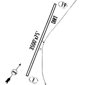
| Runways: | 01/19 |
| Longest Runway: | 01/19 is 3700 ft (1128 m) long |
| Runways with an Instrument Approach: |
E94 Airport Runway Details
| Runway 01/19 | 3700 ft x 84 ft (1128 m x 26 m) | |
| Runway Length Source: | STATE as of 05/04/2006 | |
| Surface: | Dirt - Fair condition - No special surface treatment | |
Runway 01 |
Runway 19 |
|
Elevation: |
5396.0 | 5433.0 |
Latitude: |
33-20-54.9900N | 33-21-28.9100N |
Longitude: |
108-52-09.9100W | 108-51-53.5200W |
|
Runway True Alignment: |
022 | 202 |
Glide Path Angle: |
0.0 degrees | 0.0 degrees |
Traffic Pattern: |
Left | Left |
Object at End: |
TREE | FENCE |
Object Height: |
10 | 5 |
Distance from End: |
0 | 0 |
Object Centerline Offset: |
0 ft. left and right of centerline | 0 ft. left and right of centerline |
Services
Fuel Available: |
100LL |
Landing Fees: |
No |
Parking: |
Tiedowns available |
Other Services: |
Fuel for emergency only |
Maps & Diagrams
E94 Sectional
Flight Planning
at skyvector.com
at skyvector.com