Location
Latitude: |
41-20-15.0000N (41.3375) |
Longitude: |
084-25-43.7000W (-84.428806) |
Elevation: |
706.9 feet MSL (215 m MSL) |
Magnetic Variation: |
6.4 W (as of April 2024 from WMM2020 model) |
Time Zone: |
UTC -5.0 (Standard Time) UTC -4.0 (Daylight Savings Time) |
From City: |
04 N.M. NW of Defiance, Ohio |
Found On: |
Detroit Chart |
FAA Region: |
AGL |
Contacts
Manager: |
Publicly owned: |
| TONY SAXTON 20399 AIRPORT RD DEFIANCE, OH 43512-6763 419-658-4444 |
BOARD OF CO COMMISSIONERS 500 COURT ST STE A DEFIANCE, OH 43512-2171 419-782-4761 |
Operations
Airport Status: |
Operational |
Facility Use: |
Public |
Type: |
Airport |
Activation Date: |
10/1945 |
Control tower: |
No |
Attendance (Months/Days/Hours): |
Months/Days/Hours ALL/MON-FRI/0800-1800 |
Boundary ARTCC: |
ZOB (Cleveland) |
Responsible ARTCC: |
ZOB (Cleveland) |
Lighting Schedule: |
SEE RMK |
Segmented Circle Indicator: |
No |
Traffic Pattern Altitude (MSL): |
1707 feet (520 m) |
NOTAMs Facility: |
DFI |
NOTAM-D Service: |
Yes |
International Airport of Entry: |
No |
Customs Landing Rights: |
No |
Military Landing Rights: |
Yes |
Civil/Military Joint Use: |
No |
Based Aircraft
| Single Engine: | 16 |
| Multi Engine: | 2 |
Annual Operations (as of 06/14/2023)
| Total Operations: | 9420 | |
| Air Taxi: | 1500 | 15.9% |
| GA Local: | 5100 | 54.1% |
| GA Itinerant: | 2800 | 29.7% |
| Military Aircraft: | 20 | 0.2% |
Communications
| CTAF: | 122.700 |
| Unicom: | 122.700 |
| Approach: | TOLEDO 134.35 134.35 |
| Departure: | TOLEDO 134.35 134.35 |
| ASOS: | 121.425 (419-658-2301) |
Fixed Based Operators (FBOs) & Fuel
(Click on a business for detail)
Please help us keep this information up to date. This is a FREE SERVICE just like everything else on Airport Guide! If you see that a business needs to be added, modified, or deleted please fill out our Update Form.
To add, modify, or delete a business click here.
Please help us keep this information up to date. This is a FREE SERVICE just like everything else on Airport Guide! If you see that a business needs to be added, modified, or deleted please fill out our Update Form.
Area Code: 419 |
| Business Name | Frequency | Phone | Fuel Grade |
|---|---|---|---|
| TAS Aviation
Update FBO info |
658-4444 | 100LL, Jet A |
Flight Service Stations
| Primary | Alternate | |
| FSS on Field: | N | |
| FSS Name (ID): | Cleveland(CLE) | |
| Frequency: | ||
| Toll Free Phone: | 1-800-WX-BRIEF |
Instrument Procedures / Charts
FAA Terminal Procedures valid from 0901Z 03/21/24 to 0901Z 04/18/24.
There are various types of charts available for an airport. They are listed in the Page Type column. Here is a legend for those types:
APD - Airport Diagram
DP - Departure Procedure Charts
HOT - Hot Spots
IAP - Instrument Approach Procedure Charts
MIN - Minimums
STAR - Standard Terminal Arrival Charts
| Page Type | Page Name | Volume | Action Since Last Cycle |
|---|---|---|---|
| IAP | RNAV (GPS) RWY 12 | EC-2 | |
| MIN | ALTERNATE MINIMUMS | EC-2 | |
| MIN | TAKEOFF MINIMUMS | EC-2 |
Terminal Procedures are only available for airports in several countries with more being added all the time. If you are looking for a specific country's charts, please send an email to support(at)airportguide.com stating the country name. This will be used to prioritize the implementation.
Navigation Aids (Navaids) near DFI
| Dist (NM) | ID | Morse Code | Name | Type | Freq | True Hdg | Mag Hdg |
|---|---|---|---|---|---|---|---|
| 21.0 | USE | . . _ . . . . | Fulton | NDB | 375 | 39 | 46 |
| 23.3 | GW | _ _ . . _ _ | Shenk | NDB | 227 | 265 | 271 |
| 26.2 | TO | _ _ _ _ | Tophr | NDB | 219 | 60 | 67 |
| 29.7 | VFU | . . . _ . . _ . . . _ | Stanley | NDB | 411 | 196 | 202 |
| 32.2 | TOL | _ _ _ _ . _ . . | Toledo | TACAN | 112.50 | 61 | 68 |
| 34.7 | ANQ | . _ _ . _ _ . _ | Angola | NDB | 347 | 301 | 307 |
| 35.6 | ADG | . _ _ . . _ _ . | Adrian | NDB | 278 | 26 | 33 |
| 36.2 | VWV | . . . _ . _ _ . . . _ | Waterville | VOR-DME | 113.10 | 78 | 85 |
| 38.1 | FBC | . . _ . _ . . . _ . _ . | Flag City | VORTAC | 108.20 | 126 | 133 |
| 39.2 | BNR | _ . . . _ . . _ . | Benton Ridge | NDB | 334 | 118 | 125 |
| 40.5 | FWA | . . _ . . _ _ . _ | Fort Wayne | VORTAC | 117.80 | 238 | 244 |
| 40.6 | FWA | . . _ . . _ _ . _ | Fort Wayne Baer | VOT | 111.00 | 238 | 244 |
| 43.2 | AOH | . _ _ _ _ . . . . | Allen County | VOR | 108.40 | 150 | 157 |
| 46.0 | LFD | . _ . . . . _ . _ . . | Litchfield | VOR-DME | 111.20 | 341 | 347 |
| 47.4 | FZI | . . _ . _ _ . . . . | Fostoria | NDB | 379 | 100 | 107 |
| 48.3 | TCU | _ _ . _ . . . _ | Tecumseh | NDB | 239 | 30 | 37 |
| 48.5 | OLK | _ _ _ . _ . . _ . _ | Webster Lake | VOR | 110.40 | 263 | 269 |
| 51.7 | CQA | _ . _ . _ _ . _ . _ | Lakefield | NDB | 205 | 186 | 192 |
| 53.4 | IRS | . . . _ . . . . | Sturgis | NDB | 382 | 302 | 308 |
| 55.0 | HHG | . . . . . . . . _ _ . | Huntington | NDB | 417 | 238 | 244 |
Nearby Airports with Fuel
Notices to Airmen (NOTAMS)
Remarks
| A110-2 | DEER, BIRDS, & WILDLIFE ON & INVOF ARPT. |
| A110-3 | FOR CD CTC TOLEDO APCH AT 419-865-1495. |
| A110-4 | FOR AFT HRS ACES TO LOBBY SEE SIGN ON TRML DOOR. |
| A14 | TONY@TAS-AVIATION.COM. |
| A70-FUEL-10 | 0LL 100LL & JET A+ AVBL H24 SELF SVC VIA CREDIT CARD. |
| A75 | PRIOR CDN RQRD FOR HNGR. |
| A75 1 | ROPES NOT PRVDD. |
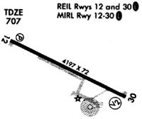
| A81-APT | ACTVT OR INCR INTST REIL RWY 12 & 30; PAPI RWY 12; MIRL RWY 12/30 - CTAF. MIRL RWY 12/30 PRESET LOW INTST. |
| E111 | ESTABD BFR 1959. |
Runways
Runway Summary
| Runways: | 12/30 |
| Longest Runway: | 12/30 is 4199 ft (1280 m) long |
| Runways with an Instrument Approach: |
DFI Airport Runway Details
| Runway 12/30 | 4199 ft x 72 ft (1280 m x 22 m) | |
| Runway Length Source: | 3RD PARTY SURVEY as of 01/25/2011 | |
| Surface: | Asphalt - Good condition - No special surface treatment | |
| Runway Edge Lights: | Medium Intensity | |
Runway 12 |
Runway 30 |
|
Elevation: |
706.9 | 699.5 |
Latitude: |
41-20-23.7024N | 41-20-06.2668N |
Longitude: |
084-26-08.6721W | 084-25-18.7297W |
|
Runway True Alignment: |
115 | 295 |
Glide Path Angle: |
3.0 degrees | 0.0 degrees |
Traffic Pattern: |
Left | Left |
Runway Markings Type: |
Nonprecision Instrument | Nonprecision Instrument |
Runway Markings Condition: |
Good | Good |
Object at End: |
TREES | TREES |
Object Height: |
60 | 75 |
Distance from End: |
1445 | 1385 |
Object Centerline Offset: |
103 ft. left of centerline | 252 ft. right of centerline |
Visual Glide Slope Indicators: |
4-Light PAPI On Left Side Of Runway | Pulsating/Steady Burning VASI On Left Side Of Runway |
REIL: |
Yes | Yes |
Touchdown Lights: |
No | No |
Centerline Lights: |
No | No |
Threshold Crossing Height: |
26 |
Services
Fuel Available: |
80, 100LL |
Landing Fees: |
No |
Parking: |
Hangars and tiedowns available |
Maps & Diagrams
DFI Sectional
Flight Planning
at skyvector.com
at skyvector.com