Location
Latitude: |
48-32-20.0000N (48.538889) |
Longitude: |
116-49-56.0000W (-116.832222) |
Elevation: |
2438.0 feet MSL (743 m MSL) |
Magnetic Variation: |
14.1 E (as of April 2024 from WMM2020 model) |
Time Zone: |
UTC -8.0 (Standard Time) UTC -7.0 (Daylight Savings Time) |
From City: |
01 N.M. NW of Cavanaugh Bay, Idaho |
Found On: |
Great Falls Chart |
FAA Region: |
ANM |
Contacts
Manager: |
Privately owned: |
| LOEL FENWICK 100 WATERBIRD LANDING COOLIN, ID 83821 208-610-2589 |
TANGLEFOOT LTD 100 WATERBIRD LANDING COOLIN, ID 83821 208-610-2589 |
Operations
Airport Status: |
Operational |
Facility Use: |
Public |
Type: |
Seaplane Base |
Activation Date: |
02/1994 |
Control tower: |
No |
Attendance (Months/Days/Hours): |
Months/Days/Hours APR-OCT/ALL/DAWN-DUSK |
Boundary ARTCC: |
ZSE (Seattle) |
Responsible ARTCC: |
ZSE (Seattle) |
Segmented Circle Indicator: |
No |
Traffic Pattern Altitude (MSL): |
3438 feet (1048 m) |
NOTAMs Facility: |
BOI |
NOTAM-D Service: |
Yes |
Based Aircraft
| Single Engine: | 1 |
| Multi Engine: | 3 |
Annual Operations (as of 06/30/2023)
| Total Operations: | 300 | |
| GA Local: | 50 | 16.7% |
| GA Itinerant: | 250 | 83.3% |
Communications
| CTAF: | 122.900 |
Fixed Based Operators (FBOs) & Fuel
(Click on a business for detail)
Please help us keep this information up to date. This is a FREE SERVICE just like everything else on Airport Guide! If you see that a business needs to be added, modified, or deleted please fill out our Update Form.
To add, modify, or delete a business click here.
Please help us keep this information up to date. This is a FREE SERVICE just like everything else on Airport Guide! If you see that a business needs to be added, modified, or deleted please fill out our Update Form.
Area Code: 208 |
| Business Name | Frequency | Phone | Fuel Grade |
|---|
Flight Service Stations
| Primary | Alternate | |
| FSS on Field: | N | |
| FSS Name (ID): | Boise(BOI) | |
| Frequency: | ||
| Toll Free Phone: | 1-800-WX-BRIEF |
Instrument Procedures / Charts
Terminal Procedures are only available for airports in several countries with more being added all the time. If you are looking for a specific country's charts, please send an email to support(at)airportguide.com stating the country name. This will be used to prioritize the implementation.
Navigation Aids (Navaids) near D28
| Dist (NM) | ID | Morse Code | Name | Type | Freq | True Hdg | Mag Hdg |
|---|---|---|---|---|---|---|---|
| 18.3 | SZT | . . . _ _ . . _ | Sandpoe | NDB | 264 | 144 | 130 |
| 25.2 | ION | . . _ _ _ _ . | Ione | NDB | 379 | 294 | 280 |
| 33.3 | U6 | Creston | NDB | 360 | 24 | 10 | |
| 39.3 | W6 | Creston North | NDB | 233 | 13 | 359 | |
| 41.7 | DPY | _ . . . _ _ . _ . _ _ | Deer Park | NDB | 365 | 214 | 200 |
| 45.9 | COE | _ . _ . _ _ _ . | Coeur D'alene | VOR-DME | 108.80 | 179 | 165 |
| 48.0 | LEN | . _ . . . _ . | Post Falls | NDB | 347 | 186 | 172 |
| 53.4 | EF | Champion | NDB | 206 | 323 | 309 | |
| 53.9 | XCG | Castlegar | DME | 110.10 | 322 | 308 | |
| 55.0 | LYI | . _ . . _ . _ _ . . | Libby | NDB | 414 | 104 | 90 |
| 55.1 | SFF | . . . . . _ . . . _ . | Spokane/Felts Field | VOT | 114.00 | 200 | 186 |
| 56.8 | YK | Brilliant | NDB | 269 | 326 | 312 | |
| 57.3 | CRK | _ . _ . . _ . _ . _ | Canyon | NDB | 388 | 205 | 191 |
| 61.8 | CG | Castlegar | NDB | 227 | 332 | 318 | |
| 62.1 | GEG | _ _ . . _ _ . | Spokane Intl | VOT | 109.60 | 206 | 192 |
| 64.9 | SKA | . . . _ . _ . _ | Fairchild | TACAN | 111.40 | 211 | 197 |
| 66.6 | GEG | _ _ . . _ _ . | Spokane | VORTAC | 115.50 | 208 | 194 |
| 67.6 | YXC | _ . _ _ _ . . _ _ . _ . | Cranbrook | VOR-DME | 112.10 | 25 | 11 |
| 69.2 | 2J | Grand Forks | NDB-DME | 250 | 295 | 281 | |
| 73.7 | EUR | . . . _ . _ . | Eureka | NDB | 392 | 69 | 55 |
Nearby Airports with Fuel
Notices to Airmen (NOTAMS)
Remarks
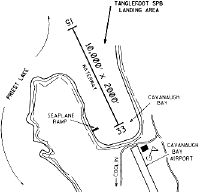
| A110-1 | TIE DOWNS AVBL AT FLOATING DOCKS; ADDNL PKNG AVBL ON BEACH. |
| A110-2 | RECOMMEND LANDING SEAPLANE RY 15; DEPARTURE SEAPLANE RY 33- WHEN WINDS PERMIT. |
| A110-3 | CAVANAUGH BAY ARPT LCD ADJ S. LOOK OUT FOR TFC & ANNC INTNS ON CTAF. |
| A110-4 | RWY 15/33 +5' NO WAKE BUOY LOCATED IN LANDING AERA |
| A110-5 | FOR CD CTC SEATTLE ARTCC AT 253-351-3694. |
| E111 | PRVDD ACFT OPERATING AT TANGLEFOOT SPB MONITOR 122.9 & ANNOUNCE INTENTIONS & ESTABLISH TFC PATTERNS THAT COINCIDE WITH CAVANAUGH BAY ARPT PATTERN. |
Runways
Runway Summary
| Runways: | 15W/33W |
| Longest Runway: | 15W/33W is 10000 ft (3048 m) long |
| Runways with an Instrument Approach: |
D28 Airport Runway Details
| Waterway 15W/33W | 10000 ft x 2000 ft (3048 m x 610 m) | |
| Surface: | Water - No special surface treatment | |
Waterway 15W |
Runway 33W |
|
Glide Path Angle: |
0.0 degrees | 0.0 degrees |
Traffic Pattern: |
Right |
Services
Airframe Repair: |
None |
Powerplant Repair: |
None |
Bottled Oxygen: |
None |
Bulk Oxygen: |
None |
Fuel Available: |
Mogas |
Landing Fees: |
No |
Parking: |
Tiedowns available |
Maps & Diagrams
D28 Sectional
Flight Planning
at skyvector.com
at skyvector.com