Location
Latitude: |
37-42-03.4920N (37.70097) |
Longitude: |
113-05-55.8630W (-113.098851) |
Elevation: |
5622.3 feet MSL (1714 m MSL) |
Magnetic Variation: |
10.8 E (as of April 2024 from WMM2020 model) |
Time Zone: |
UTC -7.0 (Standard Time) UTC -6.0 (Daylight Savings Time) |
From City: |
02 N.M. NW of Cedar City, Utah |
Found On: |
Las Vegas Chart |
FAA Region: |
ANM |
Contacts
Manager: |
Publicly owned: |
| TYLER GALETKA 2560 AVIATION WAY CEDAR CITY, UT 84721 435-867-9408 |
CEDAR CITY CORPORATION 10 NORTH MAIN CEDAR CITY, UT 84720 435-586-2950 |
Operations
Airport Status: |
Operational |
Facility Use: |
Public |
Type: |
Airport |
Activation Date: |
01/1938 |
Control tower: |
No |
Attendance (Months/Days/Hours): |
Months/Days/Hours ALL/ALL/DALGT |
Boundary ARTCC: |
ZLC (Salt Lake City) |
Responsible ARTCC: |
ZLC (Salt Lake City) |
Lighting Schedule: |
SEE RMK |
Segmented Circle Indicator: |
Yes |
Traffic Pattern Altitude (MSL): |
6622 feet (2018 m) |
NOTAMs Facility: |
CDC |
NOTAM-D Service: |
Yes |
International Airport of Entry: |
No |
Customs Landing Rights: |
No |
Military Landing Rights: |
Yes |
Civil/Military Joint Use: |
No |
Aircraft Rescue and Firefighting: |
Class I ARFF Index: A Air Carrier Service: Scheduled Certification Date: 12/2005 |
Based Aircraft
| Single Engine: | 73 |
| Multi Engine: | 3 |
| Jet Engine: | 7 |
| GA Helicopters: | 34 |
Annual Operations (as of 12/31/2022)
| Total Operations: | 119544 | |
| Commercial: | 28 | 0.0% |
| Air Taxi: | 1246 | 1.0% |
| GA Local: | 95214 | 79.6% |
| GA Itinerant: | 22506 | 18.8% |
| Military Aircraft: | 550 | 0.5% |
Communications
| CTAF: | 123.000 |
| Unicom: | 123.000 |
| ASOS: | 119.025 (435-867-0278) |
- APCH/DEP CTL SVC PRVDD BY SALT LAKE ARTCC (ZLC) ON 125.575/379.275 (CEDAR CITY RCAG).
Fixed Based Operators (FBOs) & Fuel
(Click on a business for detail)
Please help us keep this information up to date. This is a FREE SERVICE just like everything else on Airport Guide! If you see that a business needs to be added, modified, or deleted please fill out our Update Form.
To add, modify, or delete a business click here.
Please help us keep this information up to date. This is a FREE SERVICE just like everything else on Airport Guide! If you see that a business needs to be added, modified, or deleted please fill out our Update Form.
Area Code: 435 |
| Business Name | Frequency | Phone | Fuel Grade |
|---|---|---|---|
| Aero West
Update FBO info |
Unicom 122.95 | 586-2682, 865-2459 pager | 100LL, Jet A |
Flight Service Stations
| Primary | Alternate | |
| FSS on Field: | N | |
| FSS Name (ID): | Cedar City(CDC) | |
| Frequency: | ||
| Toll Free Phone: | 1-800-WX-BRIEF |
Instrument Procedures / Charts
FAA Terminal Procedures valid from 0901Z 03/21/24 to 0901Z 04/18/24.
There are various types of charts available for an airport. They are listed in the Page Type column. Here is a legend for those types:
APD - Airport Diagram
DP - Departure Procedure Charts
HOT - Hot Spots
IAP - Instrument Approach Procedure Charts
MIN - Minimums
STAR - Standard Terminal Arrival Charts
| Page Type | Page Name | Volume | Action Since Last Cycle |
|---|---|---|---|
| APD | AIRPORT DIAGRAM | SW-4 | |
| IAP | ILS OR LOC RWY 20 | SW-4 | |
| IAP | RNAV (GPS) RWY 02 | SW-4 | |
| IAP | RNAV (GPS) RWY 20 | SW-4 | |
| IAP | VOR RWY 20 | SW-4 | |
| MIN | ALTERNATE MINIMUMS | SW-4 | |
| MIN | TAKEOFF MINIMUMS | SW-4 |
Terminal Procedures are only available for airports in several countries with more being added all the time. If you are looking for a specific country's charts, please send an email to support(at)airportguide.com stating the country name. This will be used to prioritize the implementation.
Navigation Aids (Navaids) near CDC
| Dist (NM) | ID | Morse Code | Name | Type | Freq | True Hdg | Mag Hdg |
|---|---|---|---|---|---|---|---|
| 5.4 | EHK | . . . . . _ . _ | Enoch | VOR-DME | 117.30 | 15 | 4 |
| 37.7 | BCE | _ . . . _ . _ . . | Bryce Canyon | VORTAC | 112.80 | 90 | 79 |
| 39.8 | MLF | _ _ . _ . . . . _ . | Milford | VORTAC | 112.10 | 5 | 354 |
| 44.7 | AZC | . _ _ _ . . _ . _ . | Colorado City | NDB | 403 | 174 | 163 |
| 45.6 | UTI | . . _ _ . . | St George | VOR-DME | 108.60 | 206 | 195 |
| 69.6 | ILC | . . . _ . . _ . _ . | Wilson Creek | VORTAC | 116.30 | 298 | 287 |
| 79.3 | MMM | _ _ _ _ _ _ | Mormon Mesa | VORTAC | 113.10 | 225 | 214 |
| 91.3 | PGA | . _ _ . _ _ . . _ | Page | VOR-DME | 117.60 | 119 | 109 |
Nearby Airports with Fuel
| Dist (NM) | Name (Airport IDs) | True Hdg | Mag Hdg | Fuel Grade |
|---|---|---|---|---|
| 16.5 | Parowan Airport (1L9) |
54 | 43 | 100LL, Jet A |
| 35.1 | General Dick Stout Field Airport (1L8) |
196 | 185 | 100LL, Jet A, MOGAS |
| 43.7 | Milford Municipal/Ben And Judy Briscoe Field Airport (MLF KMLF MLF) |
5 | 354 | 100LL, Jet A |
| 44.4 | St George Regional Airport (SGU KDXZ SGU) |
206 | 195 | 100LL, Jet A |
| 44.6 | Colorado City Municipal Airport (KAZC AZC) |
174 | 163 | 100LL, Jet A+ |
| 45.2 | Bryce Canyon Airport (BCE KBCE BCE) |
89 | 79 | 100LL, Jet A |
| 49.5 | Kanab Municipal Airport (KNB KKNB KNB) |
146 | 136 | 100LL, Jet A |
| 62.9 | Lincoln County Airport (1L1) |
275 | 264 | 100LL |
| 69.3 | Mesquite Airport (MFH 67L) |
221 | 210 | 100LL, Jet A |
| 77.8 | Richfield Municipal Airport (RIF KRIF RIF) |
36 | 25 | 100LL, Jet A, Jet A+ |
| 81.4 | Wayne Wonderland Airport (38U) |
60 | 50 | 100LL |
| 83.0 | Fillmore Municipal Airport (FIL KFOM FOM) |
24 | 13 | 100LL, Jet A |
| 91.5 | Page Municipal Airport (PGA KPGA PGA) |
120 | 110 | 100LL, Jet A |
| 93.6 | Perkins Field Airport (U08) |
223 | 212 | 100LL |
Notices to Airmen (NOTAMS)
Remarks
| A110-1 | GA ACFT NOT PERMITTED ON ACR RAMP. |
| A110-10 | AUTOROTATE - NO AUTOROTATION TRNG TO HELIPAD. RWY 02/20 CLSD TO HEL RUN-ON LNDG; RWY 08/26 CLSD TO HEL RUN-ON LNDG; TWY A, N OF RWY 8/26 CLSD TO HEL RUN-ON LNDG; TWY C CLSD TO HEL RUN-ON LNDG. |
| A110-11 | RWY 02 LEFT TRAFFIC PATTERN EXC HELICOPTERS. RWY 20 RIGHT TRAFFIC EXC HELICOPTERS. |
| A110-12 | FOR CD IF UNA TO CTC ON FSS FREQ, CTC SALT LAKE ARTCC AT 801-320-2568. |
| A110-13 | TWY B CLSD BTWN TWY C & EAST APRON |
| A110-2 | RECOMMNED PILOTS CIRCLE ARPT FOR ALT BEFORE DEPARTING EASTBOUND DUE TO FAST RISING TERRAIN AND HI DENSITY ALT. TURBC LIKELY INVOF MNTS & PASSES. |
| A110-3 | RWY 08/26 & TWY B NOT AVBL FOR ACR ACFT. |
| A110-6 | DESIGNATED CALM WIND RWY (BLW 5 KTS) IS RWY 20, RGT TFC. |
| A110-7 | UNMON SFC CONDS 1900-0700 DLY EXC FOR SKED ACR. |
| A110-8 | EXTENSIVE HELICOPTER ACTIVITY. |
| A110-9 | EXTENSIVE FLIGHT TRNG INVOF ARPT. |
| A17 | FOR AFT HRS SVC CALL 435-586-4504 |
| A26 | CLSD TO UNSKED ACR OPNS WITH MORE THAN 30 PSGR SEATS EXCP 24 HR PPR CALL CC FIRE DEPT 435-586-2964 AND AMGR 435-867-9408. |
| A55-08 | 40 FT POLES ON EXTNDD RWY CNTRLN. |
| A70-FUEL-10 | 0LL 100LL FUEL AVBL 24 HRS SELF-SVC CREDIT CARD SYSTEM. |
| A81-APT | ACTVT MALSR RWY 20; REIL RWY 02, 08 & 26; HIRL RWY 02/20; MIRL RWY 08/26 - CTAF. PAPI RWY 02 & 20, 08 OPER CONSLY. |
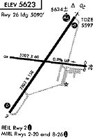
Runways
Runway Summary
| Runways: | 02/20 08/26 |
| Longest Runway: | 02/20 is 8653 ft (2637 m) long |
| Runways with an Instrument Approach: | 20 |
CDC Airport Runway Details
| Runway 02/20 | 8653 ft x 150 ft (2637 m x 46 m) | |
| Runway Length Source: | 3RD PARTY SURVEY as of 07/17/2020 | |
| Surface: | Asphalt - Good condition - Saw-cut or plastic grooved | |
| Runway Pavement Class: | 21 /F/C/X/T | |
| Runway Edge Lights: | High Intensity | |
Runway Weight Bearing Capacity (in thousands of pounds) |
||
| Single Wheel Landing Gear: | 56.0 | |
| Dual Wheel Landing Gear: | 76.0 | |
| Dual Tandem Wheel Landing Gear: | 127.0 | |
| Dual Dual Tandem Wheel Landing Gear: | 142.0 | |
Runway 02 |
Runway 20 |
|
Elevation: |
5579.8 | 5605.3 |
Latitude: |
37-41-26.1960N | 37-42-36.8780N |
Longitude: |
113-06-28.1471W | 113-05-27.5539W |
|
Runway True Alignment: |
034 | 214 |
ILS Type: |
ILS | |
Glide Path Angle: |
3.0 degrees | 3.0 degrees |
Traffic Pattern: |
Left | Right |
Runway Markings Type: |
Nonprecision Instrument | Precision Instrument |
Runway Markings Condition: |
Good | Good |
Visual Glide Slope Indicators: |
4-Light PAPI On Left Side Of Runway | 4-Light PAPI On Left Side Of Runway |
Approach Light System: |
1,400 Foot Medium Intensity Approach Lighting System With Runway Alignment Indicator Lights | |
REIL: |
Yes | |
Threshold Crossing Height: |
48 | 50 |
Declared Distances |
||
Take Off Run Avbl. (TORA): |
8653 | 8653 |
Take Off Distance Avbl. (TODA): |
8653 | 8653 |
Actual Stop Dist. Avbl. (ASDA): |
8653 | 8653 |
Landing Dist. Avbl. (LDA): |
8653 | 8653 |
| Runway 08/26 | 4822 ft x 60 ft (1470 m x 18 m) | |
| Runway Length Source: | 3RD PARTY SURVEY as of 07/17/2020 | |
| Surface: | Asphalt - Good condition - No special surface treatment | |
| Runway Pavement Class: | 8 /F/C/X/T | |
| Runway Edge Lights: | Medium Intensity | |
Runway Weight Bearing Capacity (in thousands of pounds) |
||
| Single Wheel Landing Gear: | 16.0 | |
Runway 08 |
Runway 26 |
|
Elevation: |
5578.6 | 5622.3 |
Latitude: |
37-42-09.8208N | 37-42-04.1727N |
Longitude: |
113-06-22.0671W | 113-05-22.5092W |
|
Runway True Alignment: |
097 | 277 |
Glide Path Angle: |
3.0 degrees | 0.0 degrees |
Traffic Pattern: |
Left | Right |
Runway Markings Type: |
Basic | Basic |
Runway Markings Condition: |
Good | Good |
Object at End: |
POLE | ROAD |
Object Height: |
40 | 18 |
Distance from End: |
1800 | 661 |
Visual Glide Slope Indicators: |
4-Light PAPI On Left Side Of Runway | |
REIL: |
Yes | Yes |
Threshold Crossing Height: |
47 | |
Declared Distances |
||
Take Off Run Avbl. (TORA): |
4822 | 4822 |
Take Off Distance Avbl. (TODA): |
4822 | 4822 |
Actual Stop Dist. Avbl. (ASDA): |
4822 | 4822 |
Landing Dist. Avbl. (LDA): |
4822 | 4822 |
Services
Airframe Repair: |
None |
Powerplant Repair: |
None |
Bottled Oxygen: |
None |
Bulk Oxygen: |
None |
Fuel Available: |
100LL |
Landing Fees: |
No |
Parking: |
Tiedowns available |
Other Services: |
Caretaker lives near field |
Maps & Diagrams
CDC Sectional
Flight Planning
at skyvector.com
at skyvector.com