Location
Latitude: |
41-14-41.1000N (41.24475) |
Longitude: |
082-33-04.4000W (-82.551222) |
Elevation: |
852.5 feet MSL (260 m MSL) |
Magnetic Variation: |
7.7 W (as of April 2024 from WMM2020 model) |
Time Zone: |
UTC -5.0 (Standard Time) UTC -4.0 (Daylight Savings Time) |
From City: |
03 N.M. E of Norwalk, Ohio |
Found On: |
Detroit Chart |
FAA Region: |
AGL |
Contacts
Manager: |
Publicly owned: |
| SCOTT SPARKS PO BOX 406 NORWALK, OH 44857-0406 419-706-2901 |
HURON CO COMMISSIONERS 180 MILAN AVE STE 7 NORWALK, OH 44857-1195 419-668-3092 |
Operations
Airport Status: |
Operational |
Facility Use: |
Public |
Type: |
Airport |
Control tower: |
No |
Attendance (Months/Days/Hours): |
Months/Days/Hours Unattended |
Boundary ARTCC: |
ZOB (Cleveland) |
Responsible ARTCC: |
ZOB (Cleveland) |
Lighting Schedule: |
SEE RMK |
Segmented Circle Indicator: |
No |
Traffic Pattern Altitude (MSL): |
1852 feet (564 m) |
NOTAMs Facility: |
CLE |
NOTAM-D Service: |
Yes |
International Airport of Entry: |
No |
Customs Landing Rights: |
No |
Military Landing Rights: |
No |
Civil/Military Joint Use: |
No |
Based Aircraft
| Single Engine: | 20 |
| Multi Engine: | 2 |
Annual Operations (as of 07/14/2021)
| Total Operations: | 10100 | |
| GA Local: | 6000 | 59.4% |
| GA Itinerant: | 4000 | 39.6% |
| Military Aircraft: | 100 | 1.0% |
Communications
| CTAF: | 122.800 |
| Unicom: | 122.800 |
| Approach: | CLEVELAND 124.2 124.2 CLEVELAND ARTCC |
| Departure: | CLEVELAND 124.2 124.2 CLEVELAND ARTCC |
- APCH/DEP SVC PRVDD BY CLEVELAND APCH (CLE) 0600-0100. APCH/DEP SVC PRVDD BY CLEVELAND ARTCC (ZOB) ON FREQS 135.1/291.725 (FINDLAY RCAG) 0100-0600.
Fixed Based Operators (FBOs) & Fuel
(Click on a business for detail)
Please help us keep this information up to date. This is a FREE SERVICE just like everything else on Airport Guide! If you see that a business needs to be added, modified, or deleted please fill out our Update Form.
To add, modify, or delete a business click here.
Please help us keep this information up to date. This is a FREE SERVICE just like everything else on Airport Guide! If you see that a business needs to be added, modified, or deleted please fill out our Update Form.
Area Code: 419 |
| Business Name | Frequency | Phone | Fuel Grade |
|---|
Flight Service Stations
| Primary | Alternate | |
| FSS on Field: | N | |
| FSS Name (ID): | Cleveland(CLE) | |
| Frequency: | ||
| Toll Free Phone: | 1-800-WX-BRIEF |
Instrument Procedures / Charts
FAA Terminal Procedures valid from 0901Z 03/21/24 to 0901Z 04/18/24.
There are various types of charts available for an airport. They are listed in the Page Type column. Here is a legend for those types:
APD - Airport Diagram
DP - Departure Procedure Charts
HOT - Hot Spots
IAP - Instrument Approach Procedure Charts
MIN - Minimums
STAR - Standard Terminal Arrival Charts
| Page Type | Page Name | Volume | Action Since Last Cycle |
|---|---|---|---|
| IAP | RNAV (GPS) RWY 28 | EC-2 | |
| MIN | TAKEOFF MINIMUMS | EC-2 |
Terminal Procedures are only available for airports in several countries with more being added all the time. If you are looking for a specific country's charts, please send an email to support(at)airportguide.com stating the country name. This will be used to prioritize the implementation.
Navigation Aids (Navaids) near 5A1
| Dist (NM) | ID | Morse Code | Name | Type | Freq | True Hdg | Mag Hdg |
|---|---|---|---|---|---|---|---|
| 12.3 | SKY | . . . _ . _ _ . _ _ | Sandusky | VOR-DME | 109.20 | 337 | 345 |
| 18.8 | DJB | _ . . . _ _ _ _ . . . | Dryer | VOR-DME | 113.60 | 68 | 76 |
| 21.6 | AAU | . _ . _ . . _ | Ashland | NDB | 329 | 141 | 149 |
| 21.8 | PCW | . _ _ . _ . _ . . _ _ | Port Clinton | NDB | 423 | 319 | 327 |
| 22.6 | MFD | _ _ . . _ . _ . . | Mansfield | VORTAC | 108.80 | 184 | 192 |
| 29.1 | MF | _ _ . . _ . | Manns | NDB | 372 | 170 | 178 |
| 31.3 | TII | _ . . . . | Tiffin | NDB | 269 | 253 | 260 |
| 33.3 | CLE | _ . _ . . _ . . . | Cleveland | VOT | 110.40 | 71 | 79 |
| 38.3 | FZI | . . _ . _ _ . . . . | Fostoria | NDB | 379 | 265 | 272 |
| 44.3 | BUD | _ . . . . . _ _ . . | Buckeye | VOR | 109.80 | 211 | 219 |
| 50.5 | VWV | . . . _ . _ _ . . . _ | Waterville | VOR-DME | 113.10 | 284 | 291 |
| 52.2 | MLR | _ _ . _ . . . _ . | Millersburg/Dcmsnd | NDB | 382 | 143 | 151 |
| 52.3 | BNR | _ . . . _ . . _ . | Benton Ridge | NDB | 334 | 255 | 262 |
| 53.6 | AK | . _ _ . _ | Akron | NDB | 362 | 100 | 108 |
| 53.9 | CAK | _ . _ . . _ _ . _ | Akron/Canton Regional | VOT | 110.60 | 111 | 119 |
| 57.2 | FBC | . . _ . _ . . . _ . _ . | Flag City | VORTAC | 108.20 | 252 | 259 |
| 58.0 | RYS | . _ . _ . _ _ . . . | Grosse Ile | NDB | 419 | 332 | 340 |
| 58.9 | LQL | . _ . . _ _ . _ . _ . . | Lakeland | NDB | 263 | 63 | 71 |
| 59.0 | BSV | _ . . . . . . . . . _ | Briggs | VOR-DME | 112.40 | 120 | 128 |
| 59.9 | TOL | _ _ _ _ . _ . . | Toledo | TACAN | 112.50 | 290 | 297 |
Nearby Airports with Fuel
Notices to Airmen (NOTAMS)
Remarks
| A110-1 | DRAG STRIP AT EAST END OF RWY, SOUTH SIDE, RUNNING NORTH/SOUTH. |
| A110-2 | BIRDS & WILDLIFE ON & INVOF ARPT. |
| A110-3 | RWY 28: 67 FT LGT POLES, 95 FT DIST, 320 FT LEFT IN TRSNL SFC, OBSTN MKD & LGTD. |
| A110-4 | FOR CD CTC CLEVELAND APCH AT 216-352-2323, WHEN APCH CLSD CTC CLEVELAND ARTCC AT 440-774-0222/0490. |
| A57-10 | APCH SLP 0:1 TO DTHR OVR 76 FT TREES, 0 FT DIST, 235 FT R. |
| A57-28 | OBSTN CLNC SLP 0:1 TO DTHR OVR 8 FT FENCE, 0 FT DIST, 245 FT L; 12:1 OVR 110 FT TREES, 1390 FT DIST, 225 FT R. |
| A58-10 | 52 FT TREES, 0-200 FT DIST, 240 FT R; 16 FT BRUSH/TREES, 55-200 FT DIST, 115 FT L. |
| A58-28 | 17 FT DRAG STRIP, 152 FT DIST, 242 FT L. |
| A75 | PPR. |
| A81-APT | ACTVT MIRL RWY 10/28 - CTAF. |
| E111 | VFR USE ONLY. |
Runways
Runway Summary
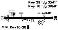
| Runways: | 10/28 |
| Longest Runway: | 10/28 is 4208 ft (1283 m) long |
| Runways with an Instrument Approach: |
5A1 Airport Runway Details
| Runway 10/28 | 4208 ft x 75 ft (1283 m x 23 m) | |
| Surface: | Asphalt - Fair condition - No special surface treatment | |
| Runway Edge Lights: | Medium Intensity | |
Runway 10 |
Runway 28 |
|
Elevation: |
834.5 | 852.1 |
Latitude: |
41-14-41.2178N | 41-14-41.0776N |
Longitude: |
082-33-31.9442W | 082-32-36.8589W |
|
Runway True Alignment: |
090 | 270 |
Glide Path Angle: |
0.0 degrees | 0.0 degrees |
Traffic Pattern: |
Left | Left |
Runway Markings Type: |
Basic | Nonprecision Instrument |
Runway Markings Condition: |
Fair | Fair |
Object at End: |
TREES | ROAD |
Object Height: |
85 | 17 |
Distance from End: |
201 | 201 |
Object Centerline Offset: |
234 ft. right of centerline | 240 ft. left of centerline |
REIL: |
No | No |
Touchdown Lights: |
No | No |
Centerline Lights: |
No | No |
Threshold Elevation: |
836.1 | 851.0 |
Displaced Threshold: |
239 | 667 |
Threshold Latitude: |
41-14-41.2102N | 41-14-41.1002N |
Threshold Longitude: |
082-33-28.8154W | 082-32-45.5937W |
Services
Airframe Repair: |
Major |
Powerplant Repair: |
Major |
Bottled Oxygen: |
High Pressure |
Bulk Oxygen: |
None |
Fuel Available: |
100LL, Jet A+ |
Landing Fees: |
No |
Parking: |
Hangars and tiedowns available |
Maps & Diagrams
5A1 Sectional
Flight Planning
at skyvector.com
at skyvector.com