Location
Latitude: |
29-08-18.2000N (29.138389) |
Longitude: |
098-56-30.8000W (-98.941889) |
Elevation: |
702.2 feet MSL (214 m MSL) |
Magnetic Variation: |
3.8 E (as of April 2024 from WMM2020 model) |
Time Zone: |
UTC -6.0 (Standard Time) UTC -5.0 (Daylight Savings Time) |
From City: |
02 N.M. W of Devine, Texas |
Found On: |
San Antonio Chart |
FAA Region: |
ASW |
Contacts
Manager: |
Publicly owned: |
| VICKIE PUMPHREY 339 CR 767 DEVINE, TX 78016 830-538-4123 |
CITY OF DEVINE 303 S TEEL DEVINE, TX 78016 830-663-2804 |
Operations
Airport Status: |
Operational |
Facility Use: |
Public |
Type: |
Airport |
Activation Date: |
01/1970 |
Control tower: |
No |
Attendance (Months/Days/Hours): |
Months/Days/Hours ALL/MON-FRI/DAWN-DUSK |
Boundary ARTCC: |
ZHU (Houston) |
Responsible ARTCC: |
ZHU (Houston) |
Lighting Schedule: |
SEE RMK |
Segmented Circle Indicator: |
Yes |
Traffic Pattern Altitude (MSL): |
1702 feet (519 m) |
NOTAMs Facility: |
SJT |
NOTAM-D Service: |
Yes |
International Airport of Entry: |
No |
Customs Landing Rights: |
No |
Military Landing Rights: |
Yes |
Based Aircraft
| Single Engine: | 11 |
| Multi Engine: | 1 |
Annual Operations (as of 05/28/2023)
| Total Operations: | 6100 | |
| GA Local: | 3600 | 59.0% |
| GA Itinerant: | 2500 | 41.0% |
Communications
| CTAF: | 122.900 |
- APCH/DEP CTL SVC PRVDD BY HOUSTON ARTCC (ZHU) ON FREQS 134.95/269.4 (UVALDE RCAG).
Fixed Based Operators (FBOs) & Fuel
(Click on a business for detail)
Please help us keep this information up to date. This is a FREE SERVICE just like everything else on Airport Guide! If you see that a business needs to be added, modified, or deleted please fill out our Update Form.
To add, modify, or delete a business click here.
Please help us keep this information up to date. This is a FREE SERVICE just like everything else on Airport Guide! If you see that a business needs to be added, modified, or deleted please fill out our Update Form.
Area Code: 830 |
| Business Name | Frequency | Phone | Fuel Grade |
|---|---|---|---|
| Air Maintenance
Update FBO info |
Unicom 122.9 | 663-3074 | |
| Aircraft Refinishers of South Texas
Update FBO info |
663-6070 |
Flight Service Stations
| Primary | Alternate | |
| FSS on Field: | N | |
| FSS Name (ID): | San Angelo(SJT) | |
| Frequency: | ||
| Toll Free Phone: | 1-800-WX-BRIEF |
Instrument Procedures / Charts
FAA Terminal Procedures valid from 0901Z 03/21/24 to 0901Z 04/18/24.
There are various types of charts available for an airport. They are listed in the Page Type column. Here is a legend for those types:
APD - Airport Diagram
DP - Departure Procedure Charts
HOT - Hot Spots
IAP - Instrument Approach Procedure Charts
MIN - Minimums
STAR - Standard Terminal Arrival Charts
| Page Type | Page Name | Volume | Action Since Last Cycle |
|---|---|---|---|
| IAP | NDB RWY 35 | SC-3 | |
| IAP | RNAV (GPS) RWY 35 | SC-3 | |
| MIN | TAKEOFF MINIMUMS | SC-3 |
Terminal Procedures are only available for airports in several countries with more being added all the time. If you are looking for a specific country's charts, please send an email to support(at)airportguide.com stating the country name. This will be used to prioritize the implementation.
Navigation Aids (Navaids) near 23R
| Dist (NM) | ID | Morse Code | Name | Type | Freq | True Hdg | Mag Hdg |
|---|---|---|---|---|---|---|---|
| 0.1 | HHH | . . . . . . . . . . . . | Devine | NDB | 359 | 92 | 88 |
| 17.7 | HDO | . . . . _ . . _ _ _ | Hondo | VOR-DME | 109.40 | 315 | 311 |
| 18.5 | HMA | . . . . _ _ . _ | Hondo | NDB | 329 | 319 | 315 |
| 24.2 | KSY | _ . _ . . . _ . _ _ | Kelly | TACAN | 112.00 | 51 | 47 |
| 27.1 | SSF | . . . . . . . . _ . | Stinson | VOR | 108.40 | 74 | 70 |
| 34.2 | SAT | . . . . _ _ | San Antonio | VOT | 110.40 | 46 | 42 |
| 34.2 | AN | . _ _ . | Alamo | NDB | 368 | 34 | 30 |
| 39.4 | SAT | . . . . _ _ | San Antonio | VORTAC | 116.80 | 39 | 35 |
| 41.1 | UVA | . . _ . . . _ . _ | Uvalde | NDB | 281 | 273 | 269 |
| 41.3 | RND | . _ . _ . _ . . | Randolph | VORTAC | 112.30 | 56 | 52 |
| 41.6 | COT | _ . _ . _ _ _ _ | Cotulla | VORTAC | 115.80 | 192 | 188 |
| 42.6 | DHK | _ . . . . . . _ . _ | Randolph | TACAN | 109.90 | 55 | 51 |
| 49.1 | CSI | _ . _ . . . . . . | Center Point | VORTAC | 117.50 | 343 | 339 |
| 49.5 | LKX | . _ . . _ . _ _ . . _ | La Pryor | NDB | 223 | 255 | 251 |
| 56.3 | THX | _ . . . . _ . . _ | Three Rivers | VORTAC | 111.40 | 132 | 128 |
| 57.4 | CPZ | _ . _ . . _ _ . _ _ . . | Chaparrosa Ranch | NDB | 385 | 254 | 250 |
| 59.4 | DMD | _ . . _ _ _ . . | Dimmit County | NDB | 343 | 231 | 227 |
| 65.3 | STV | . . . _ . . . _ | Stonewall | VORTAC | 113.80 | 10 | 6 |
| 71.5 | RU | . _ . . . _ | Garys | NDB | 272 | 46 | 42 |
| 77.9 | PFO | . _ _ . . . _ . _ _ _ | Spofford | NDB | 356 | 270 | 266 |
Nearby Airports with Fuel
Notices to Airmen (NOTAMS)
Remarks
| A110-1 | DEER ON & INVOF ARPT. |
| A110-2 | FOR CD CTC HOUSTON ARTCC AT 281-230-5622. |
| A81-APT | MIRL RWY 17/35 PRESET LOW INTST; TO INCR INTST ACTVT - CTAF. |
Runways
Runway Summary
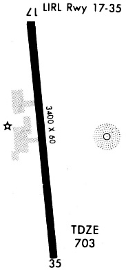
| Runways: | 17/35 |
| Longest Runway: | 17/35 is 3399 ft (1036 m) long |
| Runways with an Instrument Approach: |
23R Airport Runway Details
| Runway 17/35 | 3399 ft x 60 ft (1036 m x 18 m) | |
| Runway Length Source: | 3RD PARTY SURVEY as of 10/14/2011 | |
| Surface: | Asphalt - Good condition - No special surface treatment | |
| Runway Edge Lights: | Medium Intensity | |
Runway Weight Bearing Capacity (in thousands of pounds) |
||
| Single Wheel Landing Gear: | 12.5 | |
Runway 17 |
Runway 35 |
|
Elevation: |
673.9 | 702.2 |
Latitude: |
29-08-34.9301N | 29-08-01.5011N |
Longitude: |
098-56-33.0028W | 098-56-28.5985W |
|
Runway True Alignment: |
173 | 353 |
Glide Path Angle: |
3.0 degrees | 3.0 degrees |
Traffic Pattern: |
Left | Left |
Runway Markings Type: |
Nonprecision Instrument | Nonprecision Instrument |
Runway Markings Condition: |
Good | Good |
Object at End: |
ROAD | TREES |
Object Height: |
15 | 70 |
Distance from End: |
570 | 1675 |
Object Centerline Offset: |
0 ft. left and right of centerline | 0 ft. left and right of centerline |
Visual Glide Slope Indicators: |
2-Light PAPI On Left Side Of Runway | 2-Light PAPI On Left Side Of Runway |
Threshold Crossing Height: |
33 | 33 |
Services
Bottled Oxygen: |
None |
Bulk Oxygen: |
None |
Fuel Available: |
100LL |
Landing Fees: |
No |
Parking: |
Tiedowns available |
Maps & Diagrams
23R Sectional
Flight Planning
at skyvector.com
at skyvector.com