Location
Latitude: |
42-21-50.4000N (42.364) |
Longitude: |
074-03-54.1000W (-74.065028) |
Elevation: |
440.0 feet MSL (134 m MSL) |
Magnetic Variation: |
12.9 W (as of April 2024 from WMM2020 model) |
Time Zone: |
UTC -5.0 (Standard Time) UTC -4.0 (Daylight Savings Time) |
From City: |
01 N.M. NW of Freehold, New York |
Found On: |
New York Chart |
FAA Region: |
AEA |
Contacts
Manager: |
Privately owned: |
| ROBERT PETT PO BOX 304 FREEHOLD, NY 12431 518-253-4859 |
FREEHOLD AIRPORT LLC. C/O GERARD CALAMARI, 115 BURDEN LAKE ROAD AVERILL PARK, NY 12018 518-966-8503 |
Operations
Airport Status: |
Operational |
Facility Use: |
Public |
Type: |
Airport |
Activation Date: |
07/1969 |
Control tower: |
No |
Attendance (Months/Days/Hours): |
Months/Days/Hours APR-DEC/ALL/0900-DUSK |
Boundary ARTCC: |
ZBW (Boston) |
Responsible ARTCC: |
ZBW (Boston) |
Segmented Circle Indicator: |
No |
Traffic Pattern Altitude (MSL): |
1440 feet (439 m) |
NOTAMs Facility: |
BTV |
NOTAM-D Service: |
Yes |
International Airport of Entry: |
No |
Customs Landing Rights: |
No |
Based Aircraft
| Single Engine: | 13 |
| Gliders: | 13 |
| Ultralights: | 1 |
Annual Operations (as of 07/07/2023)
| Total Operations: | 2584 | |
| GA Local: | 2200 | 85.1% |
| GA Itinerant: | 280 | 10.8% |
| Military Aircraft: | 104 | 4.0% |
Communications
| CTAF: | 122.850 |
Fixed Based Operators (FBOs) & Fuel
(Click on a business for detail)
Please help us keep this information up to date. This is a FREE SERVICE just like everything else on Airport Guide! If you see that a business needs to be added, modified, or deleted please fill out our Update Form.
To add, modify, or delete a business click here.
Please help us keep this information up to date. This is a FREE SERVICE just like everything else on Airport Guide! If you see that a business needs to be added, modified, or deleted please fill out our Update Form.
Area Code: 518 |
| Business Name | Frequency | Phone | Fuel Grade |
|---|---|---|---|
| Catskill Valley Flying Service
Update FBO info |
Unicom 122.8 | 634-7626, 622-3307 | Mogas |
Flight Service Stations
| Primary | Alternate | |
| FSS on Field: | N | |
| FSS Name (ID): | Burlington(BTV) | |
| Frequency: | ||
| Toll Free Phone: | 1-800-WX-BRIEF |
Instrument Procedures / Charts
Terminal Procedures are only available for airports in several countries with more being added all the time. If you are looking for a specific country's charts, please send an email to support(at)airportguide.com stating the country name. This will be used to prioritize the implementation.
Navigation Aids (Navaids) near 1I5
| Dist (NM) | ID | Morse Code | Name | Type | Freq | True Hdg | Mag Hdg |
|---|---|---|---|---|---|---|---|
| 16.6 | PFH | . _ _ . . . _ . . . . . | Philmont | NDB | 272 | 113 | 126 |
| 25.1 | ALB | . _ . _ . . _ . . . | Albany | VOT | 108.20 | 25 | 38 |
| 25.7 | ALB | . _ . _ . . _ . . . | Albany | VORTAC | 115.30 | 26 | 39 |
| 30.0 | HEU | . . . . . . . _ | Hunter | NDB | 356 | 11 | 24 |
| 31.3 | GBR | _ _ . _ . . . . _ . | Great Barrington | NDB | 395 | 110 | 123 |
| 39.9 | JJH | . _ _ _ . _ _ _ . . . . | Johnstown | NDB | 523 | 342 | 355 |
| 41.1 | DNY | _ . . _ . _ . _ _ | Delancey | VOR-DME | 112.10 | 254 | 267 |
| 41.2 | PWL | . _ _ . . _ _ . _ . . | Pawling | VOR-DME | 114.30 | 149 | 162 |
| 42.9 | OZ | _ _ _ _ _ . . | Kring | NDB | 279 | 288 | 301 |
| 43.3 | IGN | . . _ _ . _ . | Kingston | VOR-DME | 117.60 | 165 | 178 |
| 47.5 | PO | . _ _ . _ _ _ | Meier | NDB | 403 | 174 | 187 |
| 49.4 | CAM | _ . _ . . _ _ _ | Cambridge | VOR-DME | 115.00 | 39 | 52 |
| 49.7 | CTR | _ . _ . _ . _ . | Chester | VOR-DME | 115.10 | 94 | 107 |
| 50.2 | SKU | . . . _ . _ . . _ | Stanwyck | FAN MARKER | 178 | 191 | |
| 50.2 | SKU | . . . _ . _ . . _ | Stanwyck | NDB | 261 | 178 | 191 |
| 50.4 | MS | _ _ . . . | Monga | NDB | 359 | 224 | 237 |
| 52.4 | RKA | . _ . _ . _ . _ | Rockdale | VOR-DME | 112.60 | 277 | 290 |
| 53.2 | SW | . . . . _ _ | Neely | NDB | 335 | 187 | 200 |
| 57.2 | GF | _ _ . . . _ . | Ganse | NDB | 209 | 20 | 33 |
| 58.5 | HNK | . . . . _ . _ . _ | Hancock | VOR-DME | 116.80 | 252 | 265 |
Nearby Airports with Fuel
Notices to Airmen (NOTAMS)
Remarks
| A110-2 | EXTENSIVE GLIDER ACTIVITY, ESPECIALLY ON WEEKENDS. |
| A110-5 | RY 12 ORCHARDS 100 FT LEFT & 112 FT RIGHT RY CNTRLN & 59 FT TREES IN APCH TO RY 288 FT FM THLD. |
| A110-6 | RGT TFC FOR GLIDERS RY 12 ONLY. |
| A110-7 | CONTACT AIRPORT MANAGER FOR FIELD CONDITIONS DEC 1 -APR 1; PH. 518-966-8503 |
| A110-8 | FOR CD CTC ALBANY APCH AT 518-862-2299. |
| A30A-12 | RGT TFC FOR GLIDERS RY 12 ONLY. |
| A31-12/30 | 100 FT BY 2640 FT TURF RWY ADJACENT TO PAVED RWY (S EDGE) BEGINNING AT 735 FT FROM RWY 30 THLD. |
| A33-12/30 | SURFACE BROKEN & SPALLING FOR ENTIRE LENGTH. |
| A52-12 | ORCHARDS 100 FT LEFT & 112 FT RIGHT RWY CNTRLN & 67 FT TREES IN APCH TO RWY 812 FT FM THLD. 3 FT HIGH FENCE & WATER PIPE ALG RWY 34 FT LEFT & ACRS RWY SAFETY AREA 200 FT WEST OF THLD. |
| A52-30 | 31 FT TREES IN APCH TO RWY 315 FT FM END OF RWY, 35 FT LEFT OF CNTRLN. |
| A58-12 | 10 FT HIGH FENCE APPROX. PARALLEL TO RWY, 42 FT LT., 50 - 700 FT FRM THSLD. |
| E111 | VFR OPNS ONLY. |
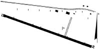
Runways
Runway Summary
| Runways: | 12/30 |
| Longest Runway: | 12/30 is 2275 ft (693 m) long |
| Runways with an Instrument Approach: |
1I5 Airport Runway Details
| Runway 12/30 | 2275 ft x 22 ft (693 m x 7 m) | |
| Surface: | Asphalt - Poor condition - No special surface treatment | |
Runway 12 |
Runway 30 |
|
Elevation: |
437.0 | 421.0 |
Latitude: |
42-21-54.2389N | 42-21-46.6326N |
Longitude: |
074-04-08.3847W | 074-03-39.8614W |
|
Runway True Alignment: |
110 | 290 |
Glide Path Angle: |
0.0 degrees | 0.0 degrees |
Traffic Pattern: |
Left | Left |
Runway Markings Type: |
None | None |
Object at End: |
TREES | TREES |
Object Height: |
70 | 35 |
Object Marked/Lighted?: |
Marked | |
Distance from End: |
812 | 315 |
Object Centerline Offset: |
85 ft. right of centerline | 35 ft. left of centerline |
Services
Airframe Repair: |
Major |
Powerplant Repair: |
Major |
Bottled Oxygen: |
High Pressure / Low Pressure |
Bulk Oxygen: |
None |
Fuel Available: |
100LL, Jet A |
Landing Fees: |
No |
Parking: |
Hangars and tiedowns available |
Maps & Diagrams
1I5 Sectional
Flight Planning
at skyvector.com
at skyvector.com