Location
Latitude: |
31-04-28.1000N (31.074472) |
Longitude: |
081-25-40.0000W (-81.427778) |
Elevation: |
11.3 feet MSL (3 m MSL) |
Magnetic Variation: |
7.1 W (as of April 2024 from WMM2020 model) |
Time Zone: |
UTC -5.0 (Standard Time) UTC -4.0 (Daylight Savings Time) |
From City: |
06 N.M. SE of Jekyll Island, Georgia |
Found On: |
Jacksonville Chart |
FAA Region: |
ASO |
Contacts
Manager: |
Publicly owned: |
| NOEL JENSEN 100 JAMES ROAD JEKYLL ISLAND, GA 31527 912-635-9330 |
JEKYLL ISLAND AUTHORITY 100 JAMES RD. JEKYLL ISLAND, GA 31527 912-635-4000 |
Operations
Airport Status: |
Operational |
Facility Use: |
Public |
Type: |
Airport |
Control tower: |
No |
Attendance (Months/Days/Hours): |
Months/Days/Hours ALL/ALL/0900-1600 |
Boundary ARTCC: |
ZJX (Jacksonville) |
Responsible ARTCC: |
ZJX (Jacksonville) |
Lighting Schedule: |
SEE RMK |
Segmented Circle Indicator: |
Yes |
Traffic Pattern Altitude (MSL): |
1011 feet (308 m) |
NOTAMs Facility: |
MCN |
NOTAM-D Service: |
Yes |
International Airport of Entry: |
No |
Customs Landing Rights: |
No |
Military Landing Rights: |
Yes |
Civil/Military Joint Use: |
No |
Based Aircraft
| Single Engine: | 6 |
| Ultralights: | 2 |
Annual Operations (as of 12/31/2022)
| Total Operations: | 27040 | |
| GA Local: | 1000 | 3.7% |
| GA Itinerant: | 26040 | 96.3% |
Communications
| CTAF: | 123.050 |
| Unicom: | 123.050 |
- APCH/DEP SVC PRVDD BY JACKSONVILLE ARTCC (ZJX) ON FREQS 126.75/277.4 (BRUNSWICK RCAG).
Fixed Based Operators (FBOs) & Fuel
(Click on a business for detail)
Please help us keep this information up to date. This is a FREE SERVICE just like everything else on Airport Guide! If you see that a business needs to be added, modified, or deleted please fill out our Update Form.
To add, modify, or delete a business click here.
Please help us keep this information up to date. This is a FREE SERVICE just like everything else on Airport Guide! If you see that a business needs to be added, modified, or deleted please fill out our Update Form.
Area Code: 912 |
| Business Name | Frequency | Phone | Fuel Grade |
|---|
Flight Service Stations
| Primary | Alternate | |
| FSS on Field: | N | |
| FSS Name (ID): | Macon(MCN) | |
| Frequency: | ||
| Toll Free Phone: | 1-800-WX-BRIEF |
Instrument Procedures / Charts
FAA Terminal Procedures valid from 0901Z 03/21/24 to 0901Z 04/18/24.
There are various types of charts available for an airport. They are listed in the Page Type column. Here is a legend for those types:
APD - Airport Diagram
DP - Departure Procedure Charts
HOT - Hot Spots
IAP - Instrument Approach Procedure Charts
MIN - Minimums
STAR - Standard Terminal Arrival Charts
| Page Type | Page Name | Volume | Action Since Last Cycle |
|---|---|---|---|
| IAP | RNAV (GPS) RWY 18 | SE-4 | |
| IAP | VOR-A | SE-4 | |
| MIN | TAKEOFF MINIMUMS | SE-4 |
Terminal Procedures are only available for airports in several countries with more being added all the time. If you are looking for a specific country's charts, please send an email to support(at)airportguide.com stating the country name. This will be used to prioritize the implementation.
Navigation Aids (Navaids) near 09J
| Dist (NM) | ID | Morse Code | Name | Type | Freq | True Hdg | Mag Hdg |
|---|---|---|---|---|---|---|---|
| 1.7 | SSI | . . . . . . . . | Brunswick | VORTAC | 109.80 | 213 | 220 |
| 12.0 | BQK | _ . . . _ _ . _ _ . _ | Brunswick | VOT | 111.00 | 352 | 359 |
| 37.1 | JES | . _ _ _ . . . . | Slover | NDB | 340 | 320 | 327 |
| 37.4 | JAX | . _ _ _ . _ _ . . _ | Jacksonville Intl | VOT | 111.00 | 201 | 208 |
| 40.2 | EYA | . _ . _ _ . _ | Eastport | NDB | 357 | 193 | 200 |
| 41.2 | NRB | _ . . _ . _ . . . | Mayport | TACAN | 111.40 | 179 | 186 |
| 41.3 | JA | . _ _ _ . _ | Dinns | NDB | 344 | 207 | 214 |
| 44.3 | CRG | _ . _ . . _ . _ _ . | Craig | VORTAC | 114.50 | 185 | 192 |
| 45.6 | MOQ | _ _ _ _ _ _ _ . _ | Mc Intosh | NDB | 263 | 354 | 361 |
| 52.0 | NIP | _ . . . . _ _ . | Jacksonville | TACAN | 108.20 | 194 | 201 |
| 52.0 | AY | . _ _ . _ _ | Wiket | NDB | 219 | 287 | 294 |
| 56.9 | VQQ | . . . _ _ _ . _ _ _ . _ | Cecil | VOR | 117.90 | 204 | 211 |
| 58.1 | SVN | . . . . . . _ _ . | Hunter | VOR-DME | 111.60 | 14 | 21 |
| 59.1 | AYS | . _ _ . _ _ . . . | Waycross | VORTAC | 110.20 | 281 | 288 |
| 60.2 | SV | . . . . . . _ | Wassa | NDB | 335 | 21 | 28 |
| 61.9 | AMG | . _ _ _ _ _ . | Alma | VORTAC | 115.10 | 296 | 303 |
| 62.4 | BHC | _ . . . . . . . _ . _ . | Baxley | NDB | 376 | 308 | 315 |
| 63.5 | SA | . . . . _ | Mavis | NDB | 368 | 4 | 11 |
| 64.2 | SAV | . . . . _ . . . _ | Savannah Travis Fld | VOT | 111.00 | 10 | 17 |
| 65.4 | SAV | . . . . _ . . . _ | Savannah | VORTAC | 115.95 | 10 | 17 |
Nearby Airports with Fuel
Notices to Airmen (NOTAMS)
Remarks
| A110-1 | TRANSITION VIOLATIONS - 55 FT TREES E OF RY & 40 FT TREES W OF RY. |
| A110-2 | ROTG BCN IS LCTD ON TOP OF A WATER TANK 1/2 - 1 MILE NE OF RY 18 IN A SWAMPY AREA. |
| A110-3 | DEER ON & INVOF OF ARPT. |
| A110-4 | FOR CD CTC JACKSONVILLE ARTCC AT 904-845-1592. |
| A14 | JEKYLL ISLAND AUTHORITY. |
| A81-APT | ACTVT MIRL RY 18/36 AND PAPI RY 18 & RY 36 - CTAF. |
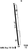
Runways
Runway Summary
| Runways: | 18/36 |
| Longest Runway: | 18/36 is 3715 ft (1132 m) long |
| Runways with an Instrument Approach: |
09J Airport Runway Details
| Runway 18/36 | 3715 ft x 75 ft (1132 m x 23 m) | |
| Runway Length Source: | 3RD PARTY SURVEY as of 07/10/2009 | |
| Surface: | Asphalt - Good condition - No special surface treatment | |
| Runway Edge Lights: | Medium Intensity | |
Runway Weight Bearing Capacity (in thousands of pounds) |
||
| Single Wheel Landing Gear: | 20.0 | |
Runway 18 |
Runway 36 |
|
Elevation: |
11.0 | 11.0 |
Latitude: |
31-04-46.4165N | 31-04-09.8200N |
Longitude: |
081-25-42.0945W | 081-25-37.9418W |
|
Runway True Alignment: |
174 | 354 |
Glide Path Angle: |
3.0 degrees | 3.2 degrees |
Traffic Pattern: |
Right | Left |
Runway Markings Type: |
Nonprecision Instrument | Nonprecision Instrument |
Runway Markings Condition: |
Good | Good |
Object at End: |
TREES | |
Object Height: |
54 | |
Object Marked/Lighted?: |
Lighted | |
Distance from End: |
201 | |
Object Centerline Offset: |
230 ft. right of centerline | |
Visual Glide Slope Indicators: |
2-Light PAPI On Left Side Of Runway | 2-Light PAPI On Left Side Of Runway |
Threshold Crossing Height: |
20 | 22 |
Declared Distances |
||
Take Off Run Avbl. (TORA): |
3715 | 3715 |
Take Off Distance Avbl. (TODA): |
3715 | 3715 |
Actual Stop Dist. Avbl. (ASDA): |
3575 | 3715 |
Landing Dist. Avbl. (LDA): |
3575 | 3575 |
Services
Airframe Repair: |
None |
Powerplant Repair: |
None |
Bottled Oxygen: |
None |
Bulk Oxygen: |
None |
Fuel Available: |
Jet A |
Landing Fees: |
No |
Parking: |
Tiedowns available |
Maps & Diagrams
09J Sectional
Flight Planning
at skyvector.com
at skyvector.com