
Location
Latitude: |
44-52-50.874N (44.880798) |
Longitude: |
063-30-30.954W (-63.508598) |
Elevation: |
477 feet MSL (145 m MSL) |
Magnetic Variation: |
16.5 W (as of April 2024 from WMM2020 model) |
Time Zone: |
UTC -4.0 (Standard Time) UTC -3.0 (Daylight Savings Time) |
Contacts
Manager: |
: |
Operations
Airport Status: |
Operational |
Facility Use: |
Public |
Type: |
Airport |
Traffic Pattern Altitude (MSL): |
1477 feet (450 m) |
Based Aircraft
Annual Operations (as of )
Communications
| RDO: | 123.275 |
| TWR: | 118.4 |
| CLNC DEL: | 123.95 |
| GND: | 121.9 |
| ATIS: | 121 |
| TRML: | 118.7 |
| MONCTON CNTR: | 118.7 |
| APN ADVSY: | 122.125 |
Fixed Based Operators (FBOs) & Fuel
(Click on a business for detail)
Please help us keep this information up to date. This is a FREE SERVICE just like everything else on Airport Guide! If you see that a business needs to be added, modified, or deleted please fill out our Update Form.
To add, modify, or delete a business click here.
Please help us keep this information up to date. This is a FREE SERVICE just like everything else on Airport Guide! If you see that a business needs to be added, modified, or deleted please fill out our Update Form.
| Business Name | Frequency | Phone | Fuel Grade |
|---|
Flight Service Stations
| Primary | Alternate | |
| FSS on Field: | ||
| FSS Name (ID): | ||
| Frequency: | ||
| Toll Free Phone: |
Instrument Procedures / Charts
Terminal Procedures are only available for airports in several countries with more being added all the time. If you are looking for a specific country's charts, please send an email to support(at)airportguide.com stating the country name. This will be used to prioritize the implementation.
Navigation Aids (Navaids) near YHZ
| Dist (NM) | ID | Morse Code | Name | Type | Freq | True Hdg | Mag Hdg |
|---|---|---|---|---|---|---|---|
| 0.7 | IHZ | Halifax | DME | 109.10 | 345 | 362 | |
| 5.2 | YHZ | Halifax | VOR-DME | 115.10 | 60 | 77 | |
| 14.6 | UAW | Shearwater | TACAN | 110.10 | 177 | 193 | |
| 32.5 | 8F | Debert | NDB | 239 | 3 | 20 | |
| 55.9 | GF | Aylesford | NDB | 341 | 279 | 295 | |
| 57.6 | 5Y | Trenton | NDB | 361 | 40 | 57 | |
| 60.6 | UZX | Greenwood | TACAN | 117.60 | 276 | 292 | |
| 67.8 | YZX | Greenwood | NDB | 266 | 272 | 288 | |
| 69.8 | A9 | Liverpool | NDB | 330 | 236 | 252 | |
| 80.1 | YG | Charlottetown | NDB | 347 | 10 | 27 | |
| 86.5 | QM | Moncton | NDB | 224 | 328 | 345 | |
| 86.6 | YYG | Charlottetown | VOR-DME | 113.80 | 10 | 27 | |
| 87.8 | ZQM | Riverview | NDB | 304 | 322 | 339 | |
| 89.7 | ZYG | Cavendish | NDB | 400 | 10 | 27 | |
| 90.3 | YQM | _ . _ _ _ _ . _ _ _ | Moncton | VORTAC | 117.30 | 330 | 347 |
| 91.1 | ZMN | Lewisville | NDB | 366 | 324 | 341 | |
| 92.3 | 5B | Summerside | NDB | 254 | 350 | 367 | |
| 99.3 | Y9 | Digby | NDB | 220 | 259 | 275 |
Nearby Airports with Fuel
| Dist (NM) | Name (Airport IDs) | True Hdg | Mag Hdg | Fuel Grade |
|---|
Notices to Airmen (NOTAMS)
Remarks
No remarks for this landing facility
Runways
Runway Summary
| Runways: | 05/23 14/32 |
| Longest Runway: | 05/23 is 10500 ft (3200 m) long |
| Runways with an Instrument Approach: |
YHZ Airport Runway Details
| Runway 05/23 | 10500 ft x 200 ft (3200 m x 61 m) | |
| Runway Edge Lights: | Yes Intensity | |
Runway 05 |
Runway 23 |
|
Elevation: |
449 | 443 |
Latitude: |
44.86859893798 | 44.88830184936 |
Longitude: |
-63.52500152587 | -63.50559997558 |
|
Runway True Alignment: |
35 | 215 |
Glide Path Angle: |
0.0 degrees | 0.0 degrees |
REIL: |
Yes | Yes |
Threshold Elevation: |
449 | 443 |
Displaced Threshold: |
361 |
| Runway 14/32 | 7700 ft x 200 ft (2347 m x 61 m) | |
| Runway Edge Lights: | Yes Intensity | |
Runway 14 |
Runway 32 |
|
Elevation: |
435 | 476 |
Latitude: |
44.89360046386 | 44.88109970092 |
Longitude: |
-63.51829910278 | -63.49420166015 |
|
Runway True Alignment: |
126 | 306 |
Glide Path Angle: |
0.0 degrees | 0.0 degrees |
REIL: |
Yes | Yes |
Threshold Elevation: |
435 | 476 |
Services
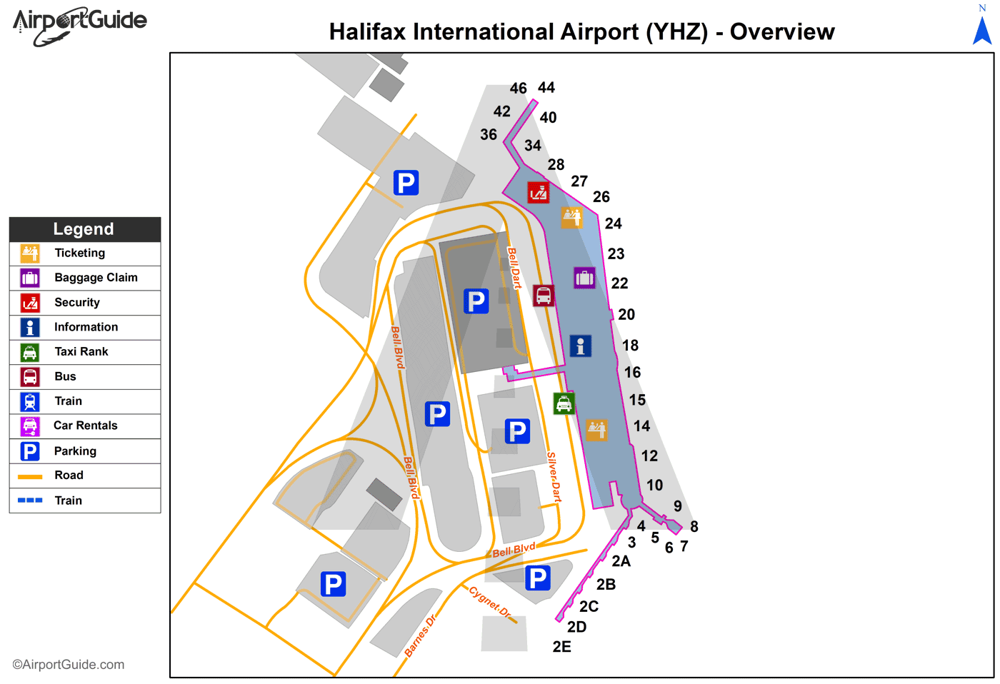
Maps & Diagrams
YHZ Sectional
Flight Planning
at skyvector.com
at skyvector.com
