Location
Latitude: |
27-48-47.7000N (27.81325) |
Longitude: |
080-29-44.1000W (-80.495583) |
Elevation: |
21.5 feet MSL (7 m MSL) |
Magnetic Variation: |
7.3 W (as of April 2024 from WMM2020 model) |
Time Zone: |
UTC -5.0 (Standard Time) UTC -4.0 (Daylight Savings Time) |
From City: |
01 N.M. W of Sebastian, Florida |
Found On: |
Miami Chart |
FAA Region: |
ASO |
Contacts
Manager: |
Publicly owned: |
| JEFFREY SABO 202 AIRPORT DRIVE EAST SEBASTIAN, FL 32958 772-228-7013 |
CITY OF SEBASTIAN 1225 MAIN STREET SEBASTIAN, FL 32958 772-638-8820 |
Operations
Airport Status: |
Operational |
Facility Use: |
Public |
Type: |
Airport |
Activation Date: |
04/1959 |
Control tower: |
No |
Attendance (Months/Days/Hours): |
Months/Days/Hours ALL/MON-FRI/0800-1700 |
Boundary ARTCC: |
ZMA (Miami) |
Responsible ARTCC: |
ZMA (Miami) |
Lighting Schedule: |
SS-SR |
Segmented Circle Indicator: |
Yes, Lighted |
Traffic Pattern Altitude (MSL): |
1022 feet (312 m) |
NOTAMs Facility: |
PIE |
NOTAM-D Service: |
Yes |
International Airport of Entry: |
No |
Customs Landing Rights: |
No |
Military Landing Rights: |
Yes |
Civil/Military Joint Use: |
No |
Based Aircraft
| Single Engine: | 67 |
| Multi Engine: | 9 |
| GA Helicopters: | 3 |
| Gliders: | 2 |
Annual Operations (as of 01/08/2018)
| Total Operations: | 37240 | |
| Air Taxi: | 1000 | 2.7% |
| GA Local: | 12240 | 32.9% |
| GA Itinerant: | 24000 | 64.4% |
Communications
| CTAF: | 123.050 |
| Approach: | MIAMI ARTCC 123.625 ;NORTH 123.625 ;NORTH |
| Departure: | MIAMI ARTCC 123.625 ;NORTH 123.625 ;NORTH |
| AWOS-3PT: | 118.125 (772-228-7020) |
Fixed Based Operators (FBOs) & Fuel
(Click on a business for detail)
Please help us keep this information up to date. This is a FREE SERVICE just like everything else on Airport Guide! If you see that a business needs to be added, modified, or deleted please fill out our Update Form.
To add, modify, or delete a business click here.
Please help us keep this information up to date. This is a FREE SERVICE just like everything else on Airport Guide! If you see that a business needs to be added, modified, or deleted please fill out our Update Form.
Area Code: 561 |
| Business Name | Frequency | Phone | Fuel Grade |
|---|---|---|---|
| Corporate Detailing Service LLC
Website Update FBO info |
1-772-532-8708 | ||
| Sebastian Aero Services
Update FBO info |
Unicom 122.8 | 589-0800 | 100LL |
| Skydive Sebastian, Inc.
Update FBO info |
Unicom 122.8 | 388-5672 | Jet A |
Flight Service Stations
| Primary | Alternate | |
| FSS on Field: | N | |
| FSS Name (ID): | Saint Petersburg(PIE) | |
| Frequency: | ||
| Toll Free Phone: | 1-800-WX-BRIEF |
Instrument Procedures / Charts
FAA Terminal Procedures valid from 0901Z 03/21/24 to 0901Z 04/18/24.
There are various types of charts available for an airport. They are listed in the Page Type column. Here is a legend for those types:
APD - Airport Diagram
DP - Departure Procedure Charts
HOT - Hot Spots
IAP - Instrument Approach Procedure Charts
MIN - Minimums
STAR - Standard Terminal Arrival Charts
| Page Type | Page Name | Volume | Action Since Last Cycle |
|---|---|---|---|
| IAP | RNAV (GPS)-A | SE-3 | |
| IAP | RNAV (GPS)-B | SE-3 | |
| MIN | TAKEOFF MINIMUMS | SE-3 |
Terminal Procedures are only available for airports in several countries with more being added all the time. If you are looking for a specific country's charts, please send an email to support(at)airportguide.com stating the country name. This will be used to prioritize the implementation.
Navigation Aids (Navaids) near X26
| Dist (NM) | ID | Morse Code | Name | Type | Freq | True Hdg | Mag Hdg |
|---|---|---|---|---|---|---|---|
| 8.1 | TRV | _ . _ . . . . _ | Treasure | VORTAC | 117.30 | 177 | 184 |
| 19.0 | MLB | _ _ . _ . . _ . . . | Melbourne | VOR-DME | 115.85 | 337 | 344 |
| 20.3 | SQT | . . . _ _ . _ _ | Satellite | NDB | 257 | 327 | 334 |
| 20.6 | FPR | . . _ . . _ _ . . _ . | Fort Pierce | NDB | 275 | 161 | 168 |
| 26.2 | COF | _ . _ . _ _ _ . . _ . | Patrick | TACAN | 115.00 | 346 | 353 |
| 44.8 | TVV | _ . . . _ . . . _ | Space Center Executive | NDB | 237 | 339 | 346 |
| 54.9 | UTX | . . _ _ _ . . _ | United | NDB | 405 | 171 | 178 |
| 62.3 | ORL | _ _ _ . _ . . _ . . | Orlando | VORTAC | 112.20 | 314 | 321 |
| 62.7 | PHK | . _ _ . . . . . _ . _ | Pahokee | VOR-DME | 115.40 | 189 | 196 |
| 64.8 | OR | _ _ _ . _ . | Herny | NDB | 221 | 310 | 317 |
| 70.4 | SFB | . . . . . _ . _ . . . | Sanford | NDB | 408 | 326 | 333 |
| 70.7 | PBI | . _ _ . _ . . . . . | Palm Beach | VOT | 109.00 | 162 | 169 |
| 71.4 | PBI | . _ _ . _ . . . . . | Palm Beach | VORTAC | 115.70 | 162 | 169 |
| 76.0 | LBV | . _ . . _ . . . . . . _ | La Belle | VORTAC | 110.40 | 219 | 226 |
| 78.1 | EVB | . . . . _ _ . . . | New Smyrna Beach | NDB | 417 | 342 | 349 |
| 81.2 | LAL | . _ . . . _ . _ . . | Lakeland | VORTAC | 116.00 | 277 | 284 |
| 85.7 | DED | _ . . . _ . . | Deland/Dcmsnd | NDB | 201 | 331 | 338 |
| 87.2 | DAB | _ . . . _ _ . . . | Daytona Beach | VOT | 111.00 | 340 | 347 |
| 91.4 | RHZ | . _ . . . . . _ _ . . | Zephyrhills | NDB | 253 | 286 | 293 |
| 91.8 | LEE | . _ . . . . | Leesburg | NDB | 335 | 311 | 318 |
Nearby Airports with Fuel
Notices to Airmen (NOTAMS)
Remarks
| A11 | CTC PERSON: BRIAN BENTON 772-638-8820 |
| A110-2 | TREES & BRUSH IN ALL TRANSITION SURFACES RY 23 & RY 28. |
| A110-3 | NOISE ABATEMENT PROCS IN EFCT: CTC AMGR 772-633-0897. |
| A110-4 | IDENTIFICATION RQR FOR ARPT ACCESS. |
| A110-5 | EXTSV PRCHT OPNS. AVOID OVERFLYING ARPT DURG PRCHT OPNS. |
| A110-6 | FOR CD CTC PALM BEACH APCH AT 561-275-1430 |
| A70-FUEL-10 | 0LL FUEL 24 HR CREDIT CARD SVC AVBL. |
| E111 | EXISTED PRIOR TO 1959. |
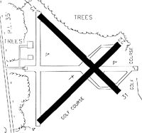
Runways
Runway Summary
| Runways: | 05/23 10/28 |
| Longest Runway: | 05/23 is 4023 ft (1226 m) long |
| Runways with an Instrument Approach: |
X26 Airport Runway Details
| Runway 05/23 | 4023 ft x 75 ft (1226 m x 23 m) | |
| Runway Length Source: | 3RD PARTY SURVEY as of 11/29/2012 | |
| Surface: | Asphalt - Fair condition - No special surface treatment | |
| Runway Pavement Class: | 6 /F/B/Y/T | |
| Runway Edge Lights: | Low Intensity | |
Runway Weight Bearing Capacity (in thousands of pounds) |
||
| Single Wheel Landing Gear: | 22.0 | |
Runway 05 |
Runway 23 |
|
Elevation: |
18.4 | 21.5 |
Latitude: |
27-48-31.2745N | 27-48-59.3954N |
Longitude: |
080-30-01.1100W | 080-29-29.3850W |
|
Runway True Alignment: |
045 | 225 |
Glide Path Angle: |
0.0 degrees | 0.0 degrees |
Traffic Pattern: |
Left | Right |
Runway Markings Type: |
Nonprecision Instrument | Nonprecision Instrument |
Runway Markings Condition: |
Fair | Fair |
Object at End: |
TREES | TREES |
Object Height: |
37 | 45 |
Distance from End: |
1090 | 1520 |
Object Centerline Offset: |
120 ft. left of centerline | 135 ft. left of centerline |
Visual Glide Slope Indicators: |
2-Light PAPI On Left Side Of Runway | 2-Light PAPI On Left Side Of Runway |
| Runway 10/28 | 3199 ft x 75 ft (975 m x 23 m) | |
| Runway Length Source: | 3RD PARTY SURVEY as of 11/29/2012 | |
| Surface: | Asphalt - Fair condition - No special surface treatment | |
| Runway Pavement Class: | 6 /F/B/Y/T | |
Runway 10 |
Runway 28 |
|
Elevation: |
18.3 | 20.8 |
Latitude: |
27-48-50.5900N | 27-48-50.5281N |
Longitude: |
080-30-00.4782W | 080-29-24.8560W |
|
Runway True Alignment: |
090 | 270 |
Glide Path Angle: |
0.0 degrees | 0.0 degrees |
Traffic Pattern: |
Right | |
Runway Markings Type: |
Basic | Basic |
Runway Markings Condition: |
Good | Good |
Object at End: |
TREES | TREES |
Object Height: |
29 | 20 |
Distance from End: |
735 | 665 |
Object Centerline Offset: |
120 ft. left of centerline | 135 ft. left of centerline |
Visual Glide Slope Indicators: |
2-Light PAPI On Left Side Of Runway | 2-Light PAPI On Left Side Of Runway |
Services
Airframe Repair: |
None |
Powerplant Repair: |
None |
Bottled Oxygen: |
None |
Bulk Oxygen: |
None |
Fuel Available: |
100LL, Jet A |
Landing Fees: |
No |
Parking: |
Hangars and tiedowns available |
Maps & Diagrams
X26 Sectional
Flight Planning
at skyvector.com
at skyvector.com