Location
Latitude: |
47-17-07.8000N (47.2855) |
Longitude: |
068-18-45.8000W (-68.312722) |
Elevation: |
987.2 feet MSL (301 m MSL) |
Magnetic Variation: |
16.2 W (as of April 2024 from WMM2020 model) |
Time Zone: |
UTC -5.0 (Standard Time) UTC -4.0 (Daylight Savings Time) |
From City: |
03 N.M. E of Frenchville, Maine |
Found On: |
Halifax Chart |
FAA Region: |
ANE |
Contacts
Manager: |
Publicly owned: |
| MATT DEROSIER 74 AIRPORT AVE FRENCHVILLE, ME 04745 207-543-6300 |
N AROOSTOOK RGNL APT AUTH 74 AIRPORT AVE FRENCHVILLE, ME 04745 207-543-6300 |
Operations
Airport Status: |
Operational |
Facility Use: |
Public |
Type: |
Airport |
Activation Date: |
06/1972 |
Control tower: |
No |
Attendance (Months/Days/Hours): |
Months/Days/Hours ALL/MON-FRI/0830-1700 |
Boundary ARTCC: |
ZBW (Boston) |
Responsible ARTCC: |
ZBW (Boston) |
Lighting Schedule: |
SEE RMK |
Segmented Circle Indicator: |
Yes |
Traffic Pattern Altitude (MSL): |
1987 feet (606 m) |
NOTAMs Facility: |
FVE |
NOTAM-D Service: |
Yes |
International Airport of Entry: |
No |
Customs Landing Rights: |
Yes |
Military Landing Rights: |
Yes |
Civil/Military Joint Use: |
No |
Based Aircraft
| Single Engine: | 10 |
Annual Operations (as of 12/31/2020)
| Total Operations: | 1314 | |
| Air Taxi: | 12 | 0.9% |
| GA Local: | 847 | 64.5% |
| GA Itinerant: | 455 | 34.6% |
Communications
| CTAF: | 122.700 |
| Unicom: | 122.700 |
| ASOS: | 135.725 (207-543-7456) |
- APCH/DEP SVC PRVDD BY BOSTON ARTCC ON FREQS 124.75/239.05 (CARIBOU RCAG).
Fixed Based Operators (FBOs) & Fuel
(Click on a business for detail)
Please help us keep this information up to date. This is a FREE SERVICE just like everything else on Airport Guide! If you see that a business needs to be added, modified, or deleted please fill out our Update Form.
To add, modify, or delete a business click here.
Please help us keep this information up to date. This is a FREE SERVICE just like everything else on Airport Guide! If you see that a business needs to be added, modified, or deleted please fill out our Update Form.
Area Code: 207 |
| Business Name | Frequency | Phone | Fuel Grade |
|---|---|---|---|
| Aroostook Aviation / Pine Status Airline
Update FBO info |
Unicom 122.8 | 543-6334 | 100LL |
Flight Service Stations
| Primary | Alternate | |
| FSS on Field: | N | |
| FSS Name (ID): | Bangor(BGR) | |
| Frequency: | ||
| Toll Free Phone: | 1-800-WX-BRIEF |
Instrument Procedures / Charts
FAA Terminal Procedures valid from 0901Z 03/21/24 to 0901Z 04/18/24.
There are various types of charts available for an airport. They are listed in the Page Type column. Here is a legend for those types:
APD - Airport Diagram
DP - Departure Procedure Charts
HOT - Hot Spots
IAP - Instrument Approach Procedure Charts
MIN - Minimums
STAR - Standard Terminal Arrival Charts
| Page Type | Page Name | Volume | Action Since Last Cycle |
|---|---|---|---|
| IAP | RNAV (GPS) RWY 14 | NE-1 | |
| IAP | RNAV (GPS) RWY 32 | NE-1 | |
| MIN | ALTERNATE MINIMUMS | NE-1 | |
| MIN | TAKEOFF MINIMUMS | NE-1 |
Terminal Procedures are only available for airports in several countries with more being added all the time. If you are looking for a specific country's charts, please send an email to support(at)airportguide.com stating the country name. This will be used to prioritize the implementation.
Navigation Aids (Navaids) near WFK
| Dist (NM) | ID | Morse Code | Name | Type | Freq | True Hdg | Mag Hdg |
|---|---|---|---|---|---|---|---|
| 31.9 | PQI | . _ _ . _ _ . _ . . | Presque Isle | VOR-DME | 116.40 | 163 | 179 |
| 42.3 | PQ | . _ _ . _ _ . _ | Excal | NDB | 278 | 163 | 179 |
| 58.8 | RI | Riviere Du Loup | NDB | 201 | 299 | 315 | |
| 59.0 | YRI | Riviere Du Loup | VOR | 113.90 | 299 | 315 | |
| 71.9 | YXK | Rimouski | NDB | 373 | 353 | 369 | |
| 76.9 | YY | Mont Joli | NDB | 340 | 1 | 17 | |
| 77.3 | HUL | . . . . . . _ . _ . . | Houlton | DME | 116.1 | 165 | 181 |
| 79.7 | YYY | Mont Joli | VOR-DME | 115.90 | 2 | 18 | |
| 79.7 | YYY | _ . _ _ _ . _ _ _ . _ _ | Mont Joli | DME | 2 | 18 | |
| 84.1 | ML | Charlevoix | NDB | 392 | 284 | 300 | |
| 87.4 | CL | Charlo | NDB | 207 | 59 | 76 | |
| 93.2 | FE | Forestville | NDB | 239 | 338 | 354 | |
| 97.8 | ME | Matane | NDB | 216 | 17 | 34 | |
| 98.7 | LNT | . _ . . _ . _ | Milnot | NDB | 344 | 185 | 201 |
Nearby Airports with Fuel
| Dist (NM) | Name (Airport IDs) | True Hdg | Mag Hdg | Fuel Grade |
|---|---|---|---|---|
| 6.5 | Long Lake Seaplane Base (92B) |
149 | 165 | MOGAS |
| 27.6 | Caribou Municipal Airport (CAR KCAR CAR) |
154 | 170 | 100LL |
| 37.4 | Presque Isle International Airport (PQI KPQI PQI) |
162 | 178 | 100LL, Jet A |
| 72.3 | Shin Pond Seaplane Base (85B) |
188 | 204 | 100LL |
| 72.9 | Houlton International Airport (HUL KHUL HUL) |
162 | 178 | 100LL, Jet A, Jet A+ |
| 96.0 | Millinocket Seaplane Base (70B) |
193 | 209 | 100LL |
| 99.5 | Millinocket Municipal Airport (MLT KMLT MLT) |
189 | 205 | 100LL, Jet A |
Notices to Airmen (NOTAMS)
Remarks
| A110-2 | WILDLIFE ON & INVOF ARPT. |
| A110-3 | FOR CD CTC BOSTON ARTCC AT 603-879-6859. |
| A16 | AMGR CELL 207-436-0715. EMAIL FRENCHVILLEAIRPORT@GMAIL.COM. |
| A70-FUEL-10 | 0LL FOR FUEL AFT HRS CALL AMGR 207-436-1350. |
| A75 | CALL 207-543-6300 FOR AVBL. |
| A81-APT | ACTVT REIL RWY 14 & 32; PAPI RWY 32; MIRL RWY 14/32 - CTAF. |
Runways
Runway Summary
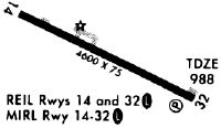
| Runways: | 14/32 |
| Longest Runway: | 14/32 is 4600 ft (1402 m) long |
| Runways with an Instrument Approach: |
WFK Airport Runway Details
| Runway 14/32 | 4600 ft x 75 ft (1402 m x 23 m) | |
| Runway Length Source: | 3RD PARTY SURVEY as of 07/16/2009 | |
| Surface: | Asphalt - Excellent condition - No special surface treatment | |
| Runway Edge Lights: | Medium Intensity | |
Runway Weight Bearing Capacity (in thousands of pounds) |
||
| Single Wheel Landing Gear: | 25.0 | |
Runway 14 |
Runway 32 |
|
Elevation: |
976.2 | 987.1 |
Latitude: |
47-17-17.6034N | 47-16-58.0228N |
Longitude: |
068-19-15.9419W | 068-18-15.7486W |
|
Runway True Alignment: |
116 | 296 |
Glide Path Angle: |
0.0 degrees | 3.0 degrees |
Traffic Pattern: |
Left | Left |
Runway Markings Type: |
Nonprecision Instrument | Nonprecision Instrument |
Runway Markings Condition: |
Good | Good |
Visual Glide Slope Indicators: |
4-Light PAPI On Left Side Of Runway | |
REIL: |
Yes | Yes |
Threshold Crossing Height: |
40 |
Services
Airframe Repair: |
None |
Powerplant Repair: |
None |
Bottled Oxygen: |
None |
Bulk Oxygen: |
None |
Fuel Available: |
100LL, Jet A |
Landing Fees: |
No |
Parking: |
Hangars and tiedowns available |
Maps & Diagrams
WFK Sectional
Flight Planning
at skyvector.com
at skyvector.com