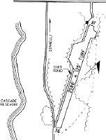
Location
Latitude: |
44-43-44.6150N (44.72906) |
Longitude: |
116-05-33.4600W (-116.092628) |
Elevation: |
4860.0 feet MSL (1481 m MSL) |
Magnetic Variation: |
13.1 E (as of April 2024 from WMM2020 model) |
Time Zone: |
UTC -7.0 (Standard Time) UTC -6.0 (Daylight Savings Time) |
From City: |
01 N.M. W of Donnelly, Idaho |
Found On: |
Great Falls Chart |
FAA Region: |
ANM |
Contacts
Manager: |
Publicly owned: |
| CAMI HEDGES PO BOX 725 OR, 169 HALFERTY ST DONNELLY, ID 83615 208-325-8859 |
CITY OF DONNELLY PO BOX 725 DONNELLY, ID 83615 208-325-8859 |
Operations
Airport Status: |
Operational |
Facility Use: |
Public |
Type: |
Airport |
Activation Date: |
10/1950 |
Control tower: |
No |
Attendance (Months/Days/Hours): |
Months/Days/Hours Unattended |
Boundary ARTCC: |
ZLC (Salt Lake City) |
Responsible ARTCC: |
ZLC (Salt Lake City) |
Segmented Circle Indicator: |
No |
Traffic Pattern Altitude (MSL): |
5860 feet (1786 m) |
NOTAMs Facility: |
BOI |
NOTAM-D Service: |
Yes |
Military Landing Rights: |
No |
Civil/Military Joint Use: |
No |
Based Aircraft
Annual Operations (as of 05/30/2023)
| Total Operations: | 1525 | |
| GA Itinerant: | 1500 | 98.4% |
| Military Aircraft: | 25 | 1.6% |
Communications
| CTAF: | 122.900 |
- COMMUNICATIONS PRVDD BY BOISE RADIO ON FREQ 122.5 (CASCADE RCO).
Fixed Based Operators (FBOs) & Fuel
(Click on a business for detail)
Please help us keep this information up to date. This is a FREE SERVICE just like everything else on Airport Guide! If you see that a business needs to be added, modified, or deleted please fill out our Update Form.
To add, modify, or delete a business click here.
Please help us keep this information up to date. This is a FREE SERVICE just like everything else on Airport Guide! If you see that a business needs to be added, modified, or deleted please fill out our Update Form.
Area Code: 208 |
| Business Name | Frequency | Phone | Fuel Grade |
|---|
Flight Service Stations
| Primary | Alternate | |
| FSS on Field: | N | |
| FSS Name (ID): | Boise(BOI) | |
| Frequency: | ||
| Toll Free Phone: | 1-800-WX-BRIEF |
Instrument Procedures / Charts
Terminal Procedures are only available for airports in several countries with more being added all the time. If you are looking for a specific country's charts, please send an email to support(at)airportguide.com stating the country name. This will be used to prioritize the implementation.
Navigation Aids (Navaids) near U84
| Dist (NM) | ID | Morse Code | Name | Type | Freq | True Hdg | Mag Hdg |
|---|---|---|---|---|---|---|---|
| 5.4 | DNJ | _ . . _ . . _ _ _ | Donnelly | VOR-DME | 116.20 | 295 | 282 |
| 57.9 | ONO | _ _ _ _ . _ _ _ | Ontario | NDB | 305 | 223 | 210 |
| 68.6 | BO | _ . . . _ _ _ | Ustik | NDB | 359 | 188 | 175 |
| 70.2 | MPA | _ _ . _ _ . . _ | Meridian | NDB | 238 | 196 | 183 |
| 70.6 | BOI | _ . . . _ _ _ . . | Boise | VOT | 116.70 | 184 | 171 |
| 70.7 | BOI | _ . . . _ _ _ . . | Boise | VORTAC | 113.30 | 183 | 170 |
| 73.4 | BKE | _ . . . _ . _ . | Baker City | VOR-DME | 115.30 | 275 | 262 |
| 81.7 | IDQ | . . _ . . _ _ . _ | Cottonwood | DME | 115.65 | 349 | 336 |
| 87.2 | LKT | . _ . . _ . _ _ | Salmon | VOR-DME | 113.50 | 77 | 64 |
| 87.4 | LGD | . _ . . _ _ . _ . . | La Grande | NDB | 296 | 295 | 282 |
| 98.7 | STI | . . . _ . . | Sturgeon | NDB | 333 | 168 | 155 |
Nearby Airports with Fuel
Notices to Airmen (NOTAMS)
Remarks
| A110-1 | NO WINTER MAINTENANCE. |
| A110-2 | BOTH SIDES RWY: +30-80 FT TREES. |
| A110-3 | NO TELEPHONE AVBL AT ARPT. |
| A110-4 | FOR CD CTC SALT LAKE ARTCC AT 801-320-2568. |
| A14 | LORI CLEMENS IS THE CITY CLERK & AMGR. |
| A30-18/36 | RCMD LAND RY 36 & TKOF RY 18 WHEN WIND CONDS PERMIT. |
| A32-18/36 | MAY BE MOWED LESS THAN FULL WIDTH. |
| A33-18/36 | RY 18/36 MAY NOT BE MOWED FULL WIDTH. |
| A52-18 | +45 FT TREES AT 0 FT 60 FT L; NMRS +20-80 FT TREES ON CNTRLN AER. |
| A52-36 | 65 FT TREES 500 FT ON CNTRLN AER. 60 FT TREES AT 0 FT, 100 FT RIGHT. |
| A57-18 | 45 FT TREES AT 0 FT, 75 FT RIGHT. |
Runways
Runway Summary
| Runways: | 18/36 |
| Longest Runway: | 18/36 is 2500 ft (762 m) long |
| Runways with an Instrument Approach: |
U84 Airport Runway Details
| Runway 18/36 | 2500 ft x 125 ft (762 m x 38 m) | |
| Surface: | Turf - Fair condition - No special surface treatment | |
Runway 18 |
Runway 36 |
|
Glide Path Angle: |
0.0 degrees | 0.0 degrees |
Traffic Pattern: |
Left | Left |
Object at End: |
TREES | TREES |
Object Height: |
60 | 45 |
Distance from End: |
0 | 0 |
Object Centerline Offset: |
100 ft. right of centerline | 75 ft. right of centerline |
Services
Airframe Repair: |
Major |
Powerplant Repair: |
Major |
Bottled Oxygen: |
None |
Bulk Oxygen: |
None |
Fuel Available: |
100, Jet A |
Landing Fees: |
No |
Parking: |
Tiedowns available |
Maps & Diagrams
U84 Sectional
Flight Planning
at skyvector.com
at skyvector.com