
Location
Latitude: |
17-42-05.4160N (17.701504) |
Longitude: |
064-48-06.9945W (-64.801943) |
Elevation: |
74.1 feet MSL (23 m MSL) |
Magnetic Variation: |
14 W (as of April 2024 from WMM2020 model) |
Time Zone: |
UTC -4.0 (Standard Time) UTC -4.0 (Daylight Savings Time) |
From City: |
06 N.M. SW of Christiansted, Virgin Islands |
Found On: |
Puerto Rico-Virgin Islands Chart |
FAA Region: |
ASO |
Contacts
Manager: |
Publicly owned: |
| JEROME SHERIDAN P.O. BOX 1134, CHRISTIANSTED ST CROIX, VI 00821 340-714-6662 |
VI PORT AUTHORITY 8074 LINDBERGH BAY, P.O. BOX 301707 ST THOMAS, VI 00803 (340) 774-1629 |
Operations
Airport Status: |
Operational |
Facility Use: |
Public |
Type: |
Airport |
Activation Date: |
09/1948 |
Control tower: |
Yes |
Attendance (Months/Days/Hours): |
Months/Days/Hours ALL/ALL/0500-2300 |
Boundary ARTCC: |
ZSU (San Juan) |
Responsible ARTCC: |
ZSU (San Juan) |
Lighting Schedule: |
SEE RMK |
Segmented Circle Indicator: |
Yes |
Traffic Pattern Altitude (MSL): |
1074 feet (327 m) |
NOTAMs Facility: |
TISX |
NOTAM-D Service: |
Yes |
International Airport of Entry: |
No |
Customs Landing Rights: |
Yes |
Military Landing Rights: |
Yes |
Civil/Military Joint Use: |
No |
Aircraft Rescue and Firefighting: |
Class I ARFF Index: C Air Carrier Service: Scheduled Certification Date: 05/1973 |
Based Aircraft
| Single Engine: | 12 |
| Multi Engine: | 17 |
| Jet Engine: | 3 |
| GA Helicopters: | 1 |
| Military Aircraft: | 3 |
| Ultralights: | 1 |
Annual Operations (as of 01/01/2019)
| Total Operations: | 11420 | |
| Commercial: | 1241 | 10.9% |
| Air Taxi: | 6935 | 60.7% |
| GA Local: | 1930 | 16.9% |
| GA Itinerant: | 1120 | 9.8% |
| Military Aircraft: | 194 | 1.7% |
Communications
| CTAF: | 118.600 |
| Unicom: | 123.000 |
| Tower: | SAINT CROIX 118.6 239.3 Hrs: 0700-2200 |
| Ground: | 121.7 |
| Approach: | SAN JUAN CERAP |
| Departure: | SAN JUAN CERAP |
| ATIS: | 135.65 Hrs: 24 |
| ASOS: | (340-778-8122) |
| EMERG: | 121.5 |
| EMERG: | 243.0 |
- APCH/DEP SVC PRVDD BY SAN JUAN CERAP ON FREQS 128.65/279.6 (PICO DEL ESTE RCAG & EL YUNQUE RCAG).
- NO SECONDARY FREQ FOR SOUTH SIDE OF ISLAND
- SAN JUAN CERAP PROVIDES IFR CLEARANCES ON FREQ 128.65 WHEN SAINT CROIX ATCT CLSD.
Fixed Based Operators (FBOs) & Fuel
(Click on a business for detail)
Please help us keep this information up to date. This is a FREE SERVICE just like everything else on Airport Guide! If you see that a business needs to be added, modified, or deleted please fill out our Update Form.
To add, modify, or delete a business click here.
Please help us keep this information up to date. This is a FREE SERVICE just like everything else on Airport Guide! If you see that a business needs to be added, modified, or deleted please fill out our Update Form.
Area Code: 809 |
| Business Name | Frequency | Phone | Fuel Grade |
|---|---|---|---|
| Alexander Hamilton Airport
Update FBO info |
778-1012, -0589 | Mogas | |
| Bohlke International Airways
Update FBO info |
Unicom 123.0 | 778-9177 | 100LL, Jet A |
| Eagle Aviation
Website Update FBO info |
122.45 | 340-344-3900 | Jet A |
Flight Service Stations
| Primary | Alternate | |
| FSS on Field: | N | |
| FSS Name (ID): | San Juan(SJU) | |
| Frequency: | ||
| Toll Free Phone: | 1-800-WX-BRIEF |
Instrument Procedures / Charts
FAA Terminal Procedures valid from 0901Z 03/21/24 to 0901Z 04/18/24.
There are various types of charts available for an airport. They are listed in the Page Type column. Here is a legend for those types:
APD - Airport Diagram
DP - Departure Procedure Charts
HOT - Hot Spots
IAP - Instrument Approach Procedure Charts
MIN - Minimums
STAR - Standard Terminal Arrival Charts
| Page Type | Page Name | Volume | Action Since Last Cycle |
|---|---|---|---|
| APD | AIRPORT DIAGRAM | SE-3 | |
| DP | HAMILTON NINE | SE-3 | |
| DP | SNOOZ FIVE | SE-3 | |
| IAP | ILS OR LOC RWY 10 | SE-3 | Changed |
| IAP | RNAV (GPS) RWY 10 | SE-3 | |
| IAP | RNAV (GPS) RWY 28 | SE-3 | |
| IAP | VOR RWY 28 | SE-3 | |
| MIN | ALTERNATE MINIMUMS | SE-3 | |
| MIN | TAKEOFF MINIMUMS | SE-3 |
Terminal Procedures are only available for airports in several countries with more being added all the time. If you are looking for a specific country's charts, please send an email to support(at)airportguide.com stating the country name. This will be used to prioritize the implementation.
Navigation Aids (Navaids) near STX
| Dist (NM) | ID | Morse Code | Name | Type | Freq | True Hdg | Mag Hdg |
|---|---|---|---|---|---|---|---|
| 4.8 | SX | Peste | NDB | 241 | 263 | 277 | |
| 4.8 | ST | . . . _ | Peste | NDB | 241 | 263 | 277 |
| 6.1 | COY | _ . _ . _ _ _ _ . _ _ | St Croix | VOR-DME | 108.20 | 71 | 85 |
| 41.3 | STT | . . . _ _ | St Thomas | VOR-DME | 108.60 | 342 | 356 |
| 47.2 | BFI | Beef Island | NDB | 360 | 18 | 32 | |
| 57.8 | NRR | _ . . _ . . _ . | Roosevelt Roads | TACAN | 113.80 | 303 | 317 |
| 81.1 | SJU | . . . . _ _ _ . . _ | San Juan | VORTAC | 114.00 | 303 | 317 |
| 84.8 | SJ | . . . . _ _ _ | Patty | NDB | 330 | 300 | 314 |
| 98.2 | PJM | . _ _ . . _ _ _ _ _ | Saint Maarten | VOR-DME | 113.00 | 77 | 91 |
| 98.2 | PJM | St.mMarten | VOR-DME | 113.00 | 77 | 91 | |
| 98.3 | PJD | St.mMarten | NDB | 284 | 77 | 91 | |
| 99.6 | PSE | . _ _ . . . . . | Ponce | DME | 280 | 294 |
Nearby Airports with Fuel
| Dist (NM) | Name (Airport IDs) | True Hdg | Mag Hdg | Fuel Grade |
|---|---|---|---|---|
| 39.4 | Cyril E King Airport (STT TIST STT) |
345 | 359 | 100LL, Jet A |
| 58.1 | Jose Aponte De La Torre Airport (TJRV RVR) |
304 | 318 | 100LL, Jet A |
| 81.5 | Luis Munoz Marin International Airport (SJU TJSJ SJU) |
303 | 317 | 100, Jet A+, Jet A++ |
| 86.7 | Fernando Luis Ribas Dominicci Airport (SIG TJIG SIG) |
301 | 315 | 100, Jet A |
Notices to Airmen (NOTAMS)
Remarks
| A110-10 | AP SFC COND UNMON DLY 2300 - 0600 AST. |
| A110-3 | APCH TO RY 28 SMTMS OBSCD BY SMOKE FM LANDFILL LCTD E OF ARPT. |
| A110-6 | BIRDS & WILDLIFE ON & INVOF ARPT. |
| A110-8 | TAXI INTO POSITION AND HOLD PROCEDURES NO LONGER IN EFFECT. |
| A110-9 | WHEN TWR CLSD CTC SAN JUAN CERAP AT 787-253-8664/8665 |
| A26 | CLSD TO UNSKED ACR OPNS WITH MORE THAN 30 PSGR SEATS EXCP 24 HRS PPR CTC AMGR 340-778-1012 OR 340-778-1033(FAX). ARFF SVC UNAVBL 2300-0500. |
| A70-FUEL-10 | 0LL FUEL AVBL 0700-1900, OTHER TIMES 1 HR PPR CALL 340-778-9177. |
| A81-APT | ACTVT MALSR RWY 10: HIRL RWY 10/28 2300-0700 - CTAF. |
Runways
Runway Summary
| Runways: | 10/28 |
| Longest Runway: | 10/28 is 10004 ft (3049 m) long |
| Runways with an Instrument Approach: | 10 |
STX Airport Runway Details
| Runway 10/28 | 10004 ft x 150 ft (3049 m x 46 m) | |
| Runway Length Source: | AVN as of 03/09/2006 | |
| Surface: | Asphalt - Good condition - Saw-cut or plastic grooved | |
| Runway Pavement Class: | 62 /F/C/W/T | |
| Runway Edge Lights: | High Intensity | |
Runway Weight Bearing Capacity (in thousands of pounds) |
||
| Single Wheel Landing Gear: | 100.0 | |
| Dual Wheel Landing Gear: | 175.0 | |
| Dual Tandem Wheel Landing Gear: | 300.0 | |
Runway 10 |
Runway 28 |
|
Elevation: |
73.7 | 22.5 |
Latitude: |
17-42-00.2120N | 17-42-10.6200N |
Longitude: |
064-48-58.4450W | 064-47-15.5440W |
|
Runway True Alignment: |
084 | 264 |
ILS Type: |
ILS | |
Glide Path Angle: |
3.0 degrees | 3.0 degrees |
Traffic Pattern: |
Right | Left |
Runway Markings Type: |
Precision Instrument | Nonprecision Instrument |
Runway Markings Condition: |
Good | Good |
Object at End: |
BLDG | |
Object Height: |
217 | |
Object Marked/Lighted?: |
Marked | |
Distance from End: |
5330 | |
Object Centerline Offset: |
800 ft. right of centerline | |
Visual Glide Slope Indicators: |
4-Light PAPI On Left Side Of Runway | 4-Light PAPI On Left Side Of Runway |
Approach Light System: |
1,400 Foot Medium Intensity Approach Lighting System With Runway Alignment Indicator Lights | |
REIL: |
Yes | |
Threshold Crossing Height: |
73 | 80 |
Threshold Elevation: |
27.3 | |
Displaced Threshold: |
1006 | |
Threshold Latitude: |
17-42-09.5750N | |
Threshold Longitude: |
064-47-25.8920W | |
Declared Distances |
||
Take Off Run Avbl. (TORA): |
10004 | 10004 |
Take Off Distance Avbl. (TODA): |
10004 | 10004 |
Actual Stop Dist. Avbl. (ASDA): |
9003 | 10004 |
Landing Dist. Avbl. (LDA): |
9003 | 8998 |
Services
Airframe Repair: |
Major |
Powerplant Repair: |
Major |
Bottled Oxygen: |
High Pressure / Low Pressure |
Bulk Oxygen: |
None |
Fuel Available: |
100, Jet A |
Landing Fees: |
Yes |
Parking: |
Tiedowns available |
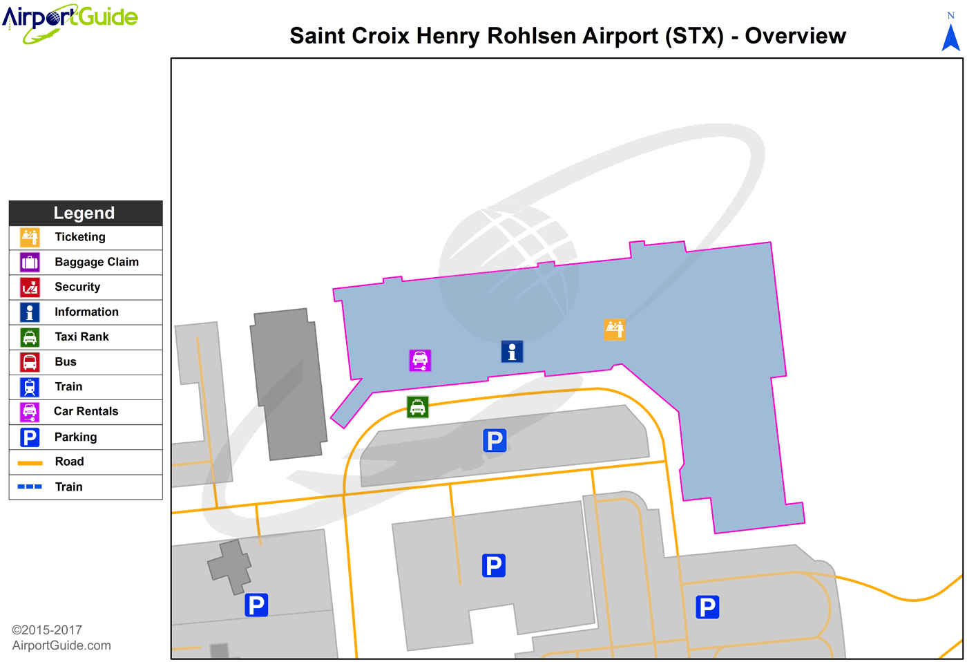
Maps & Diagrams
STX Sectional
Flight Planning
at skyvector.com
at skyvector.com
 Diagram")