Location
Latitude: |
34-50-54.9210N (34.848589) |
Longitude: |
111-47-18.4110W (-111.788448) |
Elevation: |
4830.5 feet MSL (1472 m MSL) |
Magnetic Variation: |
9.9 E (as of April 2024 from WMM2020 model) |
Time Zone: |
UTC -7.0 (Standard Time) UTC -7.0 (Daylight Savings Time) |
From City: |
02 N.M. SW of Sedona, Arizona |
Found On: |
Phoenix Chart |
FAA Region: |
AWP |
Contacts
Manager: |
Publicly owned: |
| EDWARD A. ROSE 235 AIR TERMINAL DRIVE SEDONA, AZ 86336 928-282-4487 |
YAVAPAI COUNTY 1015 FAIR ST. PRESCOTT, AZ 86305 (928) 771-3200 |
Operations
Airport Status: |
Operational |
Facility Use: |
Public |
Type: |
Airport |
Activation Date: |
05/1956 |
Control tower: |
No |
Attendance (Months/Days/Hours): |
Months/Days/Hours MAY-SEP/ALL/0700-1800 |
Boundary ARTCC: |
ZAB (Albuquerque) |
Responsible ARTCC: |
ZAB (Albuquerque) |
Lighting Schedule: |
SEE RMK |
Segmented Circle Indicator: |
Yes |
Traffic Pattern Altitude (MSL): |
5830 feet (1777 m) |
NOTAMs Facility: |
SEZ |
NOTAM-D Service: |
Yes |
International Airport of Entry: |
No |
Customs Landing Rights: |
No |
Military Landing Rights: |
Yes |
Civil/Military Joint Use: |
No |
Based Aircraft
| Single Engine: | 53 |
| Multi Engine: | 6 |
| GA Helicopters: | 4 |
| Gliders: | 1 |
Annual Operations (as of 05/11/2022)
| Total Operations: | 35000 | |
| Air Taxi: | 10850 | 31.0% |
| GA Local: | 8750 | 25.0% |
| GA Itinerant: | 14000 | 40.0% |
| Military Aircraft: | 1400 | 4.0% |
Communications
| CTAF: | 123.000 |
| Unicom: | 123.000 |
| Approach: | PHOENIX 126.375 126.375 |
| Departure: | PHOENIX 126.375 126.375 |
| AWOS-3PT: | 118.525 (928-282-1993) |
- COMMUNICATIONS PRVDD BY PRESCOTT RADIO ON FREQ 122.3 (COTTONWOOD RCO).
Fixed Based Operators (FBOs) & Fuel
(Click on a business for detail)
Please help us keep this information up to date. This is a FREE SERVICE just like everything else on Airport Guide! If you see that a business needs to be added, modified, or deleted please fill out our Update Form.
To add, modify, or delete a business click here.
Please help us keep this information up to date. This is a FREE SERVICE just like everything else on Airport Guide! If you see that a business needs to be added, modified, or deleted please fill out our Update Form.
Area Code: 520 |
| Business Name | Frequency | Phone | Fuel Grade |
|---|---|---|---|
| Aero Vista
Update FBO info |
282-7768 | ||
| Arizona Helicopter Adventures
Update FBO info |
282-0904 | ||
| Canyon Mesa Aviation
Update FBO info |
282-6317, emergency call 282-1046 | ||
| Red Rock Aviation
Update FBO info |
Unicom 123.0 | 282-1046, 800-636-8488 | 100LL, Jet A |
| Red Rock Biplane Tours
Update FBO info |
204-5939 | ||
| Sedona Sky Treks
Update FBO info |
284-2998 | ||
| Sky King Glider Tours
Update FBO info |
203-1111 | ||
| Skydance Helicopter
Update FBO info |
282-1651 | ||
| Westwind Aviation
Update FBO info |
282-2037 |
Flight Service Stations
| Primary | Alternate | |
| FSS on Field: | N | |
| FSS Name (ID): | Prescott(PRC) | |
| Frequency: | ||
| Toll Free Phone: | 1-800-WX-BRIEF |
Instrument Procedures / Charts
FAA Terminal Procedures valid from 0901Z 03/21/24 to 0901Z 04/18/24.
There are various types of charts available for an airport. They are listed in the Page Type column. Here is a legend for those types:
APD - Airport Diagram
DP - Departure Procedure Charts
HOT - Hot Spots
IAP - Instrument Approach Procedure Charts
MIN - Minimums
STAR - Standard Terminal Arrival Charts
| Page Type | Page Name | Volume | Action Since Last Cycle |
|---|---|---|---|
| IAP | RNAV (GPS) RWY 03 | SW-4 | Changed |
| MIN | ALTERNATE MINIMUMS | SW-4 | |
| MIN | TAKEOFF MINIMUMS | SW-4 | |
| ODP | BYTER ONE (OBSTACLE) (RNAV) | SW-4 |
Terminal Procedures are only available for airports in several countries with more being added all the time. If you are looking for a specific country's charts, please send an email to support(at)airportguide.com stating the country name. This will be used to prioritize the implementation.
Navigation Aids (Navaids) near SDX
| Dist (NM) | ID | Morse Code | Name | Type | Freq | True Hdg | Mag Hdg |
|---|---|---|---|---|---|---|---|
| 18.8 | FLG | . . _ . . _ . . _ _ . | Flagstaff | VOR-DME | 113.85 | 17 | 7 |
| 33.4 | PRC | . _ _ . . _ . _ . _ . | Prescott | VOT | 110.00 | 249 | 239 |
| 35.2 | DRK | _ . . . _ . _ . _ | Drake | VORTAC | 114.10 | 255 | 245 |
| 42.1 | PAN | . _ _ . . _ _ . | Payson | DME | 116.35 | 147 | 137 |
| 50.5 | INW | . . _ . . _ _ | Winslow | VORTAC | 112.60 | 75 | 65 |
| 69.0 | GCN | _ _ . _ . _ . _ . | Grand Canyon | VOR-DME | 111.65 | 345 | 335 |
| 80.5 | TBC | _ _ . . . _ . _ . | Tuba City | VORTAC | 113.50 | 18 | 8 |
| 83.2 | FFZ | . . _ . . . _ . _ _ . . | Falcon Field | NDB | 281 | 178 | 168 |
| 84.0 | LUF | . _ . . . . _ . . _ . | Luke | TACAN | 113.00 | 200 | 190 |
| 85.4 | PXR | . _ _ . _ . . _ . _ . | Phoenix | VORTAC | 115.60 | 186 | 176 |
| 85.5 | PHX | . _ _ . . . . . _ . . _ | Phoenix | VOT | 109.00 | 187 | 177 |
| 93.0 | IWA | . . . _ _ . _ | Willie | VORTAC | 113.30 | 175 | 165 |
| 94.6 | SOW | . . . _ _ _ . _ _ | Show Low | NDB | 206 | 111 | 101 |
| 94.9 | CHD | _ . _ . . . . . _ . . | Chandler | NDB | 407 | 180 | 170 |
| 97.8 | PGS | . _ _ . _ _ . . . . | Peach Springs | VOR-DME | 112.00 | 298 | 288 |
| 98.3 | BXK | _ . . . _ . . _ _ . _ | Buckeye | VORTAC | 110.60 | 211 | 201 |
Nearby Airports with Fuel
Notices to Airmen (NOTAMS)
Remarks
| A110-1 | ARPT ON 500 FT MESA. |
| A110-11 | TURB & WILDLIFE ON & INVOF ARPT. |
| A110-12 | FOR CD CTC PHOENIX APCH AT 602-306-2565. |
| A110-4 | LNDG FEE FOR TURBINE ACFT WO FUEL PURCHASE. OVERNIGHT TSNT FEE. |
| A110-5 | HOP FM HELI S & W OF RWY; HOP RSTRD TO HELI ADJ TO TWY INTXN A7 SW MAIN TRML BLDG. |
| A110-6 | NOISE ABATEMENT PROC IN EFCT; SCENIC FLT BLW 6500 FT MSL NA. |
| A16 | EMERG 928-300-3304. |
| A30-03/21 | RWY 03 CALM WIND RWY. |
| A30A-03 | UPHILL SLOPE. |
| A30A-21 | LNDG DURG STRONG SW WIND EXP STRONG DOWN DRAFT NE OF AOR. |
| A43-21 | PAPI UNUSBL BYD 2.0 NM. |
| A58-03 | 1 FT FENCE POST 125 FT FM THR 75 FT L OF CNTRLN LGTD SS-SR. |
| A58-21 | 8 FT FENCE 100-200 FT FM THR 90-125 FT L OF CNTRLN LGTD SS-SR. |
| A70-FUEL-10 | 0LL FUEL OPS TIL 30 MIN PRIOR TO CLOSING; CALL OUT FEE AFT HR. |
| A75 | CALL PRIOR - 928-282-1046. |
| A81-APT | ACTVT REIL RWY 03 & 21; PAPI RWY 03 & 21; MIRL RWY 03/21 - CTAF. |
| E147 | TPA FOR PROPELLER ACFT 1173 AGL, JET ACFT 2173 AGL. |
Runways
Runway Summary
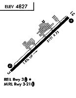
| Runways: | 03/21 H1 |
| Longest Runway: | 03/21 is 5132 ft (1564 m) long |
| Runways with an Instrument Approach: |
SDX Airport Runway Details
| Runway 03/21 | 5132 ft x 100 ft (1564 m x 30 m) | |
| Runway Length Source: | 3RD PARTY SURVEY as of 02/16/2011 | |
| Surface: | Asphalt - Good condition - No special surface treatment | |
| Runway Edge Lights: | Medium Intensity | |
Runway Weight Bearing Capacity (in thousands of pounds) |
||
| Single Wheel Landing Gear: | 15.0 | |
| Dual Wheel Landing Gear: | 30.0 | |
Runway 03 |
Runway 21 |
|
Elevation: |
4736.3 | 4830.3 |
Latitude: |
34-50-37.2211N | 34-51-12.6206N |
Longitude: |
111-47-40.4588W | 111-46-56.3596W |
|
Runway True Alignment: |
045 | 225 |
Glide Path Angle: |
3.0 degrees | 3.5 degrees |
Traffic Pattern: |
Left | Left |
Runway Markings Type: |
Nonprecision Instrument | Basic |
Runway Markings Condition: |
Good | Good |
Object at End: |
FENCE | |
Object Height: |
8 | |
Distance from End: |
201 | |
Object Centerline Offset: |
70 ft. left of centerline | |
Visual Glide Slope Indicators: |
4-Light PAPI On Left Side Of Runway | 4-Light PAPI On Left Side Of Runway |
REIL: |
Yes | Yes |
Touchdown Lights: |
No | No |
Centerline Lights: |
No | No |
Threshold Crossing Height: |
44 | 49 |
| Helipad H1 | 50 ft x 50 ft (15 m x 15 m) | |
| Runway Length Source: | FAA-EST IMAGERY as of 03/05/2020 | |
| Surface: | Asphalt - Good condition - No special surface treatment | |
| Runway Edge Lights: | Flood lights (for helipads) Intensity | |
Helipad H1 |
||
Elevation: |
4757.0 | |
Latitude: |
34-50-49.1100N | |
Longitude: |
111-47-32.9700W | |
Glide Path Angle: |
0.0 degrees | 0.0 degrees |
Object Centerline Offset: |
70 ft. left of centerline |
Services
Airframe Repair: |
Minor |
Powerplant Repair: |
Minor |
Bottled Oxygen: |
None |
Bulk Oxygen: |
None |
Fuel Available: |
100LL, Jet A |
Landing Fees: |
No |
Parking: |
Tiedowns available |
Maps & Diagrams
SDX Sectional
Flight Planning
at skyvector.com
at skyvector.com