
Location
Latitude: |
34-25-34.2900N (34.426192) |
Longitude: |
119-50-29.3740W (-119.841493) |
Elevation: |
13.5 feet MSL (4 m MSL) |
Magnetic Variation: |
11.9 E (as of April 2024 from WMM2020 model) |
Time Zone: |
UTC -8.0 (Standard Time) UTC -7.0 (Daylight Savings Time) |
From City: |
07 N.M. W of Santa Barbara, California |
Found On: |
Los Angeles Chart |
FAA Region: |
AWP |
Contacts
Manager: |
Publicly owned: |
| CHRISTOPHER HASTERT 601 FIRESTONE RD SANTA BARBARA, CA 93117 805-967-7111 |
CITY OF SANTA BARBARA CITY HALL SANTA BARBARA, CA 93101 805-967-7111 |
Operations
Airport Status: |
Operational |
Facility Use: |
Public |
Type: |
Airport |
Activation Date: |
04/1940 |
Control tower: |
Yes |
Attendance (Months/Days/Hours): |
Months/Days/Hours ALL/ALL/0600-2300 |
Boundary ARTCC: |
ZLA (Los Angeles) |
Responsible ARTCC: |
ZLA (Los Angeles) |
Lighting Schedule: |
SEE RMK |
Segmented Circle Indicator: |
Yes |
Traffic Pattern Altitude (MSL): |
1014 feet (309 m) |
NOTAMs Facility: |
SBA |
NOTAM-D Service: |
Yes |
International Airport of Entry: |
No |
Customs Landing Rights: |
No |
Military Landing Rights: |
Yes |
Civil/Military Joint Use: |
No |
Aircraft Rescue and Firefighting: |
Class I ARFF Index: B Air Carrier Service: Scheduled Certification Date: 05/1973 |
Based Aircraft
| Single Engine: | 88 |
| Multi Engine: | 9 |
| Jet Engine: | 17 |
| GA Helicopters: | 1 |
| Gliders: | 2 |
Annual Operations (as of 12/31/2020)
| Total Operations: | 90939 | |
| Commercial: | 6935 | 7.6% |
| Air Taxi: | 10842 | 11.9% |
| GA Local: | 33359 | 36.7% |
| GA Itinerant: | 38193 | 42.0% |
| Military Aircraft: | 1610 | 1.8% |
Communications
| CTAF: | 119.700 |
| Unicom: | 122.950 |
| Tower: | SANTA BARBARA 119.7 254.35 Hrs: 0600-2300 |
| Clearance Del.: | 132.9 |
| Ground: | 121.7 |
| Approach: | SANTA BARBARA 120.55 ;151-329 124.15 125.4 ;330-150 127.725 244.575 291.1 ;330-150 319.15 ;151-329 327.8 Hrs: 0600-2300 L.A. CENTER ARTCC Hrs: 2300-0600 |
| Departure: | SANTA BARBARA 120.55 ;151-329 124.15 125.4 ;330-150 127.725 244.575 291.1 ;330-150 319.15 ;151-329 327.8 Hrs: 0600-2300 L.A. CENTER ARTCC Hrs: 2300-0600 |
| ATIS: | 132.65 Hrs: 24 |
| ASOS: | 132.65 (805-681-0583) |
| CLASS C: | 125.4 ;330-150 |
| CLASS C: | 319.15 ;151-329 |
| CLASS C: | 120.55 ;151-329 |
| GAUCH DP: | 319.15 |
| GAUCH DP: | 120.55 |
| MISHN DP: | 319.15 |
| MISHN DP: | 120.55 |
| EMERG: | 243.0 |
| EMERG: | 121.5 |
| CLASS C: | 291.1 ;330-150 |
- APCH/DEP CTL SVC PRVDD BY LOS ANGELES ARTCC (ZLA) ON FREQS 119.05/269.5 (SANTA BARBARA RCAG) WHEN SANTA BARBARA APCH CTL (SBA) CLSD.
Fixed Based Operators (FBOs) & Fuel
(Click on a business for detail)
Please help us keep this information up to date. This is a FREE SERVICE just like everything else on Airport Guide! If you see that a business needs to be added, modified, or deleted please fill out our Update Form.
To add, modify, or delete a business click here.
Please help us keep this information up to date. This is a FREE SERVICE just like everything else on Airport Guide! If you see that a business needs to be added, modified, or deleted please fill out our Update Form.
Area Code: 805 |
| Business Name | Frequency | Phone | Fuel Grade |
|---|---|---|---|
| Above All Aviation
Update FBO info |
967-2116 | ||
| ASB Avionics
Update FBO info |
964-4334 | ||
| Business Aircraft
Update FBO info |
964-0632 | ||
| Mercury Air Center
Update FBO info |
Unicom 122.95 | 964-6733 | 100LL, Jet A |
| NAviation
Update FBO info |
692-1967 | ||
| Signature Flight Support
Website Update FBO info |
Arinc: 131.475 | +1 805 967 5608 | 100LL, Jet A |
| Signature Maintenance
Website Update FBO info |
Unicom 123.3 | 967-5608 | 100LL, Jet A |
| Spitfire Aviation
Update FBO info |
967-4373 | ||
| Stratman Aero Service
Update FBO info |
967-8096 |
Flight Service Stations
| Primary | Alternate | |
| FSS on Field: | N | |
| FSS Name (ID): | Hawthorne(HHR) | |
| Frequency: | ||
| Toll Free Phone: | 1-800-WX-BRIEF |
Instrument Procedures / Charts
FAA Terminal Procedures valid from 0901Z 03/21/24 to 0901Z 04/18/24.
There are various types of charts available for an airport. They are listed in the Page Type column. Here is a legend for those types:
APD - Airport Diagram
DP - Departure Procedure Charts
HOT - Hot Spots
IAP - Instrument Approach Procedure Charts
MIN - Minimums
STAR - Standard Terminal Arrival Charts
| Page Type | Page Name | Volume | Action Since Last Cycle |
|---|---|---|---|
| APD | AIRPORT DIAGRAM | SW-3 | |
| DP | FLOUT FIVE | SW-3 | |
| DP | GAUCH TWO (RNAV) | SW-3 | |
| DP | HABUT FOUR | SW-3 | |
| DP | KWANG FIVE | SW-3 | |
| DP | MISHN THREE (RNAV) | SW-3 | |
| DP | SANTA BARBARA FIVE | SW-3 | |
| DP | SANTA BARBARA FIVE[DELIMITER] CONT.1 | SW-3 | |
| HOT | HOT SPOT | SW-3 | |
| IAP | ILS OR LOC RWY 07 | SW-3 | |
| IAP | RNAV (GPS) RWY 07 | SW-3 | |
| IAP | VOR OR GPS RWY 25 | SW-3 | |
| MIN | ALTERNATE MINIMUMS | SW-3 | |
| MIN | DIVERSE VECTOR AREA | SW-3 | |
| MIN | TAKEOFF MINIMUMS | SW-3 | |
| STAR | PITBL ONE (RNAV) | SW-3 |
Terminal Procedures are only available for airports in several countries with more being added all the time. If you are looking for a specific country's charts, please send an email to support(at)airportguide.com stating the country name. This will be used to prioritize the implementation.
Navigation Aids (Navaids) near SBA
| Dist (NM) | ID | Morse Code | Name | Type | Freq | True Hdg | Mag Hdg |
|---|---|---|---|---|---|---|---|
| 6.1 | RZS | . _ . _ _ . . . . . | San Marcus | VORTAC | 114.90 | 34 | 22 |
| 13.9 | GVO | _ _ . . . . _ _ _ _ | Gaviota | VORTAC | 113.80 | 297 | 285 |
| 39.2 | CMA | _ . _ . _ _ . _ | Camarillo | VOR-DME | 115.80 | 108 | 96 |
| 40.0 | FLW | . . _ . . _ . . . _ _ | Fellows | VOR-DME | 117.50 | 358 | 346 |
| 40.0 | NTD | _ . _ _ . . | Point Mugu | TACAN | 110.60 | 116 | 104 |
| 41.0 | VBG | . . . _ _ . . . _ _ . | Vandenberg | TACAN | 112.25 | 296 | 284 |
| 43.5 | VTU | . . . _ _ . . _ | Ventura | VOR-DME | 108.20 | 115 | 103 |
| 46.1 | GLJ | _ _ . . _ . . . _ _ _ | Guadalupe | VOR | 113.05 | 313 | 301 |
| 47.7 | FIM | . . _ . . . _ _ | Fillmore | VORTAC | 112.50 | 94 | 82 |
| 53.4 | GMN | _ _ . _ _ _ . | Gorman | VORTAC | 116.10 | 64 | 52 |
| 64.4 | LHS | . _ . . . . . . . . . | Lake Hughes | VORTAC | 114.35 | 75 | 63 |
| 67.1 | MQO | _ _ _ _ . _ _ _ _ | Morro Bay | VORTAC | 112.40 | 317 | 305 |
| 68.0 | VNY | . . . _ _ . _ . _ _ | Van Nuys | VOR-DME | 113.10 | 99 | 87 |
| 71.4 | PAI | . _ _ . . _ . . | Pacoima | NDB | 370 | 97 | 85 |
| 71.6 | BFL | _ . . . . . _ . . _ . . | Bakersfield | VOT | 111.20 | 32 | 20 |
| 73.1 | SMO | . . . _ _ _ _ _ | Santa Monica | VOR-DME | 110.80 | 109 | 97 |
| 73.3 | EHF | . . . . . . . _ . | Shafter | VORTAC | 115.40 | 29 | 17 |
| 73.6 | AVE | . _ . . . _ . | Avenal | VOR-DME | 117.10 | 354 | 342 |
| 73.8 | UR | . . _ . _ . | Vinee | NDB | 253 | 100 | 88 |
| 74.0 | NSI | _ . . . . . . | San Nicolas | TACAN | 110.20 | 164 | 152 |
Nearby Airports with Fuel
Notices to Airmen (NOTAMS)
Remarks
| A110-10 | RWY 15L/33R DALGT HRS ONLY. |
| A110-11 | COML AIRLINE RAMP CLSD TO ALL GA ACFT. |
| A110-14 | NO CUSTOMS PSNL OR FACS ARE AVBL AND INTL ACFT WILL NOT BE ALLOWED TO LAND UNLESS AN EMERG EXISTS. |
| A110-4 | NUMEROUS FLOCKS OF BIRDS ON AND INVOF ARPT. |
| A110-5 | PURE JET TOUCH/GO OR LOW APCHS PROHIBITED. |
| A110-7 | DUE TO LMTD RAMP SPACE AT THE AIRLINE TRML NON-SKED TRNSP CAT ACFT WITH MORE THAN 30 PASSENGER SEATS ARE RQRD TO CTC ARPT OPNS 805-681-4803 24 HRS PRIOR TO ARR. |
| A110-9 | NOISE ABATEMENT PROCS IN EFCT CTC ARPT OPNS 805-692-6011. |
| A14 | MICHAEL SMITH - OPS MGR - MJSMITH@SANTABARBARACA.GOV |
| A26 | RWYS 15L/33R AND 15R/33L NOT AVBL FOR SKED ACR OPNS WITH MORE THAN 9 PSGR SEATS OR UNSKED ACR AT LEAST 31 PSGR SEATS. |
| A70-FUEL-A | FEE FOR JET A FUEL AFTER HRS CALL (805) 454-0051 OR 967-5608. |
| A70-FUEL-10 | 0LL 100LL FUEL 24 HR CREDIT CARD SVC AVBL. |
| A81-APT | WHEN ATCT CLSD ACTVT REIL RWY 15R; MIRL RWY 15R/33L - CTAF. MALSR RWY 07; REIL RWY 25; PAPI RWY 25; HIRL RWY 07/25 OPR CONSLY. |
| E147 | TPA 990 FT SML ACFT; 1490 FT LRG ACFT. |
| E79 | LDG FEE FOR PART 135 OPRS AND TSNT ACFT WITH MAX GWT OF 10000 LBS OR MORE. FEES WILL BE BILLED/MAILED. |
Runways
Runway Summary
| Runways: | 07/25 15L/33R 15R/33L |
| Longest Runway: | 07/25 is 6052 ft (1845 m) long |
| Runways with an Instrument Approach: | 07 |
SBA Airport Runway Details
| Runway 07/25 | 6052 ft x 150 ft (1845 m x 46 m) | |
| Runway Length Source: | 3RD PARTY SURVEY as of 09/22/2022 | |
| Surface: | Asphalt - Good condition - Saw-cut or plastic grooved | |
| Runway Pavement Class: | 66 /F/A/X/U | |
| Runway Edge Lights: | High Intensity | |
Runway Weight Bearing Capacity (in thousands of pounds) |
||
| Single Wheel Landing Gear: | 110.0 | |
| Dual Wheel Landing Gear: | 160.0 | |
| Dual Tandem Wheel Landing Gear: | 245.0 | |
Runway 07 |
Runway 25 |
|
Elevation: |
11.4 | 12.0 |
Latitude: |
34-25-38.9964N | 34-25-40.5035N |
Longitude: |
119-51-16.7098W | 119-50-04.4836W |
|
Runway True Alignment: |
089 | 269 |
ILS Type: |
ILS/DME | |
Glide Path Angle: |
0.0 degrees | 3.0 degrees |
Traffic Pattern: |
Right | Left |
Runway Markings Type: |
Precision Instrument | Precision Instrument |
Runway Markings Condition: |
Good | Good |
Object at End: |
TREE | FENCE |
Object Height: |
77 | 6 |
Distance from End: |
3100 | 275 |
Object Centerline Offset: |
350 ft. right of centerline | 0 ft. left and right of centerline |
Visual Glide Slope Indicators: |
4-Light PAPI On Left Side Of Runway | |
Runway Visual Range (RVR): |
Touchdown | Rollout |
Approach Light System: |
1,400 Foot Medium Intensity Approach Lighting System With Runway Alignment Indicator Lights | |
REIL: |
No | Yes |
Touchdown Lights: |
No | No |
Centerline Lights: |
No | No |
Threshold Crossing Height: |
50 | |
Declared Distances |
||
Take Off Run Avbl. (TORA): |
6052 | 6052 |
Take Off Distance Avbl. (TODA): |
6052 | 6052 |
Actual Stop Dist. Avbl. (ASDA): |
6052 | 6052 |
Landing Dist. Avbl. (LDA): |
6052 | 6052 |
| Runway 15L/33R | 4180 ft x 75 ft (1274 m x 23 m) | |
| Runway Length Source: | 3RD PARTY SURVEY as of 06/08/2012 | |
| Surface: | Asphalt - Good condition - No special surface treatment | |
| Runway Pavement Class: | 14 /F/A/X/T | |
Runway Weight Bearing Capacity (in thousands of pounds) |
||
| Single Wheel Landing Gear: | 35.0 | |
| Dual Wheel Landing Gear: | 41.0 | |
| Dual Tandem Wheel Landing Gear: | 63.0 | |
Runway 15L |
Runway 33R |
|
Elevation: |
11.1 | 11.3 |
Latitude: |
34-25-50.8102N | 34-25-10.7491N |
Longitude: |
119-50-25.3281W | 119-50-12.9814W |
|
Runway True Alignment: |
166 | 346 |
Glide Path Angle: |
0.0 degrees | 0.0 degrees |
Traffic Pattern: |
Left | Right |
Runway Markings Type: |
Basic | Basic |
Runway Markings Condition: |
Good | Good |
Object at End: |
BLDG | |
Object Height: |
37 | |
Distance from End: |
900 | |
Object Centerline Offset: |
350 ft. right of centerline | 0 ft. left and right of centerline |
REIL: |
No | No |
Touchdown Lights: |
No | No |
Centerline Lights: |
No | No |
Declared Distances |
||
Take Off Run Avbl. (TORA): |
4180 | 4180 |
Take Off Distance Avbl. (TODA): |
4180 | 4180 |
Actual Stop Dist. Avbl. (ASDA): |
4180 | 4180 |
Landing Dist. Avbl. (LDA): |
3963 | 4180 |
| Runway 15R/33L | 4184 ft x 100 ft (1275 m x 30 m) | |
| Runway Length Source: | 3RD PARTY SURVEY as of 09/22/2022 | |
| Surface: | Asphalt - Good condition - No special surface treatment | |
| Runway Pavement Class: | 19 /F/A/X/U | |
| Runway Edge Lights: | Medium Intensity | |
Runway Weight Bearing Capacity (in thousands of pounds) |
||
| Single Wheel Landing Gear: | 48.0 | |
| Dual Wheel Landing Gear: | 63.0 | |
| Dual Tandem Wheel Landing Gear: | 100.0 | |
Runway 15R |
Runway 33L |
|
Elevation: |
11.1 | 11.0 |
Latitude: |
34-25-49.9454N | 34-25-09.8460N |
Longitude: |
119-50-29.5330W | 119-50-17.1654W |
|
Runway True Alignment: |
166 | 346 |
Glide Path Angle: |
0.0 degrees | 0.0 degrees |
Traffic Pattern: |
Left | Right |
Runway Markings Type: |
Basic | Basic |
Runway Markings Condition: |
Good | Good |
Object at End: |
TREE | TREE |
Object Height: |
53 | 65 |
Distance from End: |
600 | 1300 |
Object Centerline Offset: |
350 ft. right of centerline | 0 ft. left and right of centerline |
REIL: |
Yes | No |
Touchdown Lights: |
No | No |
Centerline Lights: |
No | No |
Declared Distances |
||
Take Off Run Avbl. (TORA): |
4184 | 4184 |
Take Off Distance Avbl. (TODA): |
4184 | 4184 |
Actual Stop Dist. Avbl. (ASDA): |
4184 | 4184 |
Landing Dist. Avbl. (LDA): |
4184 | 4184 |
Services
Airframe Repair: |
Major |
Powerplant Repair: |
Major |
Bottled Oxygen: |
High Pressure |
Bulk Oxygen: |
High Pressure |
Fuel Available: |
100LL, Jet A |
Landing Fees: |
No |
Parking: |
Tiedowns available |
Other Services: |
Shuttle service to LAX with fuel purchase only |
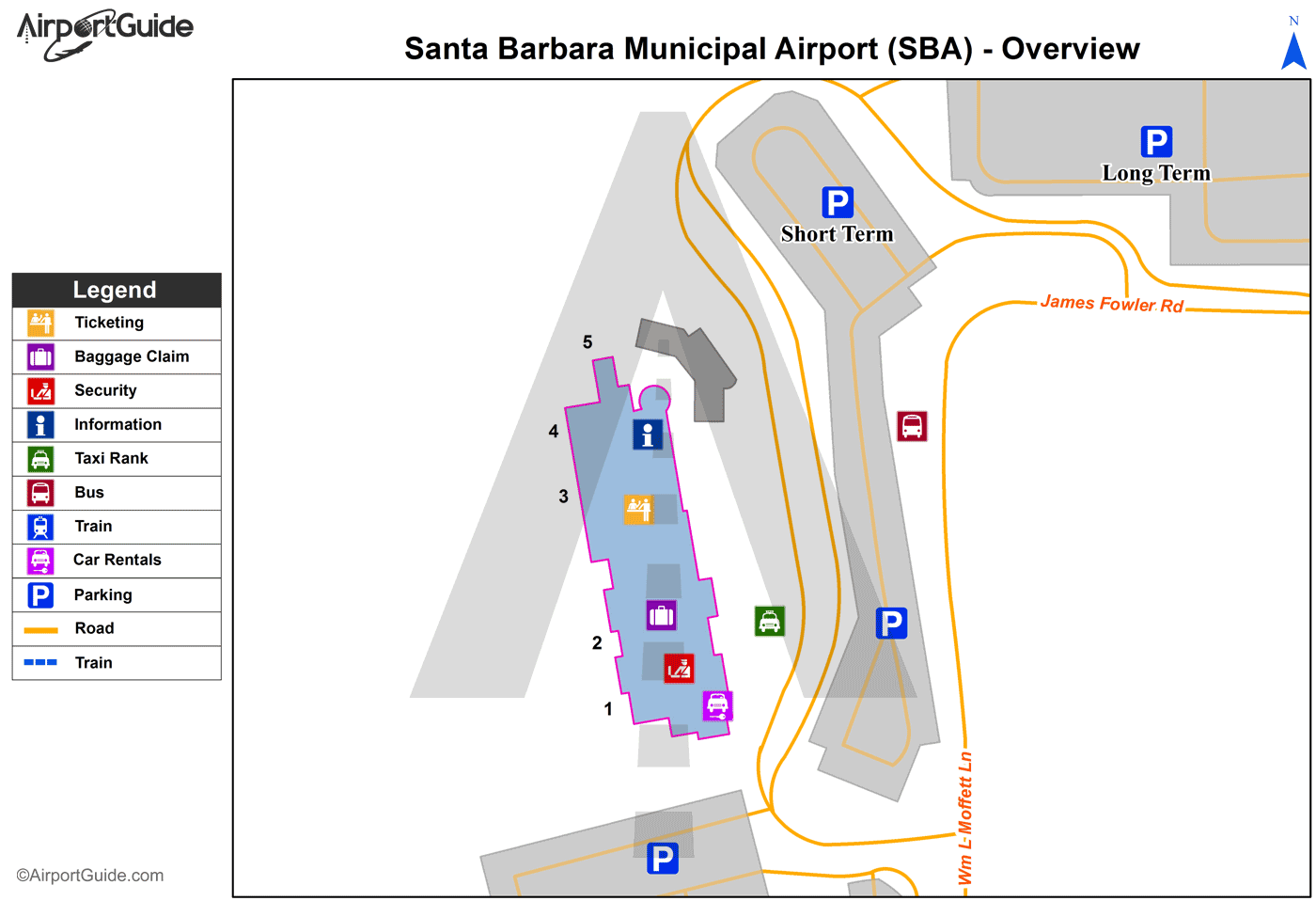
Maps & Diagrams
SBA Sectional
Flight Planning
at skyvector.com
at skyvector.com
 Diagram")