Location
Latitude: |
62-57-40.2000N (62.961167) |
Longitude: |
141-55-41.1000W (-141.928083) |
Elevation: |
1720.1 feet MSL (524 m MSL) |
Magnetic Variation: |
17.5 E (as of April 2024 from WMM2020 model) |
Time Zone: |
UTC -9.0 (Standard Time) UTC -8.0 (Daylight Savings Time) |
From City: |
00 N.M. S of Northway, Alaska |
Found On: |
Anchorage Chart |
FAA Region: |
AAL |
Contacts
Manager: |
Publicly owned: |
| SAM JENNINGS BOX 356 TOK, AK 99780 907-883-5128 |
ALASKA DOT&PF NORTHERN REGION 2301 PEGER RD. FAIRBANKS, AK 99709 907-451-2200 |
Operations
Airport Status: |
Operational |
Facility Use: |
Public |
Type: |
Airport |
Activation Date: |
07/1947 |
Control tower: |
No |
Attendance (Months/Days/Hours): |
Months/Days/Hours Unattended |
Boundary ARTCC: |
ZAN (Anchorage) |
Responsible ARTCC: |
ZAN (Anchorage) |
Lighting Schedule: |
SEE RMK |
Segmented Circle Indicator: |
Yes |
Traffic Pattern Altitude (MSL): |
2720 feet (829 m) |
NOTAMs Facility: |
ORT |
NOTAM-D Service: |
Yes |
International Airport of Entry: |
No |
Customs Landing Rights: |
Yes |
Civil/Military Joint Use: |
No |
Based Aircraft
Annual Operations (as of 12/31/2019)
| Total Operations: | 15800 | |
| Air Taxi: | 4000 | 25.3% |
| GA Local: | 3500 | 22.2% |
| GA Itinerant: | 8000 | 50.6% |
| Military Aircraft: | 300 | 1.9% |
Communications
| CTAF: | 123.600 |
| ASOS: | 135.4 (907-778-2282) |
- APCH/DEP SVC PRVDD BY ANCHORAGE ARTCC ON FREQS 126.55/323.0 (NORTHWAY RCAG).
- CONTRACT WX OBS IS AVBL WHEN ORT FSS CLSD ON 133.55 OR PHONE 907-778-2240.
- COMMUNICATIONS PRVDD BY NORTHWAY FSS ON FREQ 123.6 (CTAF).
Fixed Based Operators (FBOs) & Fuel
(Click on a business for detail)
Please help us keep this information up to date. This is a FREE SERVICE just like everything else on Airport Guide! If you see that a business needs to be added, modified, or deleted please fill out our Update Form.
To add, modify, or delete a business click here.
Please help us keep this information up to date. This is a FREE SERVICE just like everything else on Airport Guide! If you see that a business needs to be added, modified, or deleted please fill out our Update Form.
Area Code: 907 |
| Business Name | Frequency | Phone | Fuel Grade |
|---|---|---|---|
| Larson's Northway Airport Enterprises
Update FBO info |
778-2266 | 100LL, Jet A |
Flight Service Stations
| Primary | Alternate | |
| FSS on Field: | Y | |
| FSS Name (ID): | Northway(ORT) | Fairbanks (FAI) |
| Frequency: | ||
| Toll Free Phone: | 1-800-478-6611 | 1-866-248-6516 |
Instrument Procedures / Charts
FAA Terminal Procedures valid from 0901Z 03/21/24 to 0901Z 04/18/24.
There are various types of charts available for an airport. They are listed in the Page Type column. Here is a legend for those types:
APD - Airport Diagram
DP - Departure Procedure Charts
HOT - Hot Spots
IAP - Instrument Approach Procedure Charts
MIN - Minimums
STAR - Standard Terminal Arrival Charts
| Page Type | Page Name | Volume | Action Since Last Cycle |
|---|---|---|---|
| IAP | RNAV (GPS) RWY 05 | AK-1 | |
| IAP | RNAV (GPS) RWY 23 | AK-1 | |
| IAP | VOR/DME-A | AK-1 | |
| MIN | ALTERNATE MINIMUMS | AK-1 | |
| MIN | TAKEOFF MINIMUMS | AK-1 |
Terminal Procedures are only available for airports in several countries with more being added all the time. If you are looking for a specific country's charts, please send an email to support(at)airportguide.com stating the country name. This will be used to prioritize the implementation.
Navigation Aids (Navaids) near ORT
| Dist (NM) | ID | Morse Code | Name | Type | Freq | True Hdg | Mag Hdg |
|---|---|---|---|---|---|---|---|
| 0.9 | AES | . _ . . . . | Nabesna | NDB | 390 | 144 | 127 |
| 0.9 | ORT | _ _ _ . _ . _ | Northway | VORTAC | 116.30 | 153 | 136 |
| 44.5 | YXQ | _ . _ _ _ . . _ _ _ . _ | Beaver Creek | NDB | 239 | 138 | 120 |
| 97.8 | DA | Dawson City | NDB | 214 | 47 | 29 |
Nearby Airports with Fuel
| Dist (NM) | Name (Airport IDs) | True Hdg | Mag Hdg | Fuel Grade |
|---|---|---|---|---|
| 35.5 | Tok Junction Airport (TKJ PFTO 6K8) |
308 | 291 | 100LL, Jet A |
Notices to Airmen (NOTAMS)
Remarks
| A110-1 | WINTER SN REMOVAL OPS - CTAF. |
| A110-10 | NORTHWAY ARPT WX CAMERA AND KNOB RIDGE WX CAMERA AVBL ON INTERNET AT HTTPS://WEATHERCAMS.FAA.GOV/. |
| A110-11 | FSS ON ARPT 15 JUN-30 SEP. |
| A110-12 | FOREIGN ARR ORT/PAOR OR YARGER LAKE +2 HR PPR; NMLLY 1800Z-0000Z - U.S. CUSTOMS 907-774-2242/2252. |
| A110-13 | ELEC FILED EAPIS MANIFEST REQ PRIOR TO DEP. |
| A110-14 | COLD TEMPERATURE AIRPORT. ALTITUDE CORRECTION REQUIRED AT OR BELOW -38C. |
| A110-4 | FLOATPLANE CUST SVC AVBL YARGER LAKE 8 NM E. |
| A110-8 | SUAIS - 125.3/126.3 OR 800-758-8723. |
| A110-9 | RWY COND UNMN; RCMD VISUAL INSP PRIOR TO LNDG. |
| A30-05/23 | FQT VRB STRONG CROSSWIND. |
| A30A-23 | SKI STRIP PARL & ADJ THR NW SIDE. |
| A81-APT | ACTVT REIL RWY 23; PAPI RWY 05 & 23; MIRL RWY 05/23 - CTAF. |
Runways
Runway Summary
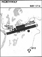
| Runways: | 05/23 |
| Longest Runway: | 05/23 is 5100 ft (1554 m) long |
| Runways with an Instrument Approach: |
ORT Airport Runway Details
| Runway 05/23 | 5100 ft x 100 ft (1554 m x 30 m) | |
| Runway Length Source: | 3RD PARTY SURVEY as of 07/15/2012 | |
| Surface: | Asphalt - Good condition - Saw-cut or plastic grooved | |
| Runway Edge Lights: | Medium Intensity | |
Runway 05 |
Runway 23 |
|
Elevation: |
1720.1 | 1718.7 |
Latitude: |
62-57-34.1910N | 62-57-46.2577N |
Longitude: |
141-56-34.6047W | 141-54-47.5567W |
|
Runway True Alignment: |
076 | 256 |
Glide Path Angle: |
3.0 degrees | 3.0 degrees |
Traffic Pattern: |
Left | Left |
Runway Markings Type: |
Nonprecision Instrument | Nonprecision Instrument |
Runway Markings Condition: |
Good | Good |
Object at End: |
TREES | TREES |
Object Height: |
61 | 60 |
Distance from End: |
2029 | 1195 |
Object Centerline Offset: |
425 ft. left of centerline | |
Visual Glide Slope Indicators: |
4-Light PAPI On Left Side Of Runway | 4-Light PAPI On Left Side Of Runway |
REIL: |
No | Yes |
Threshold Crossing Height: |
39 | 36 |
Services
Fuel Available: |
100LL, Jet A |
Parking: |
Tiedowns available |
Maps & Diagrams
ORT Sectional
Flight Planning
at skyvector.com
at skyvector.com