Location
Latitude: |
41-07-10.1000N (41.119472) |
Longitude: |
101-46-10.9000W (-101.769694) |
Elevation: |
3279.3 feet MSL (1000 m MSL) |
Magnetic Variation: |
6 E (as of April 2024 from WMM2020 model) |
Time Zone: |
UTC -7.0 (Standard Time) UTC -6.0 (Daylight Savings Time) |
From City: |
02 N.M. W of Ogallala, Nebraska |
Found On: |
Cheyenne Chart |
FAA Region: |
ACE |
Contacts
Manager: |
Publicly owned: |
| BRUCE SMITH 411 E 2ND STREET OGALLALA, NE 69153-2631 308-284-6001 |
CITY OF OGALLALA 411 E 2ND STREET OGALLALA, NE 69153-2631 308-284-6001 |
Operations
Airport Status: |
Operational |
Facility Use: |
Public |
Type: |
Airport |
Activation Date: |
04/1940 |
Control tower: |
No |
Attendance (Months/Days/Hours): |
Months/Days/Hours ALL/MON-FRI/0730-1630 |
Boundary ARTCC: |
ZDV (Denver) |
Responsible ARTCC: |
ZDV (Denver) |
Lighting Schedule: |
SEE RMK |
Segmented Circle Indicator: |
Yes |
Traffic Pattern Altitude (MSL): |
4279 feet (1304 m) |
NOTAMs Facility: |
OGA |
NOTAM-D Service: |
Yes |
International Airport of Entry: |
No |
Customs Landing Rights: |
No |
Military Landing Rights: |
Yes |
Civil/Military Joint Use: |
No |
Based Aircraft
| Single Engine: | 11 |
Annual Operations (as of 05/26/2021)
| Total Operations: | 4930 | |
| GA Local: | 1852 | 37.6% |
| GA Itinerant: | 3000 | 60.9% |
| Military Aircraft: | 78 | 1.6% |
Communications
| CTAF: | 122.800 |
| Unicom: | 122.800 |
| AWOS-3: | 121.275 (308-284-6573) |
- APCH/DEP CTL SVC PRVDD BY DENVER ARTCC (ZDV) ON FREQS 132.7/397.85 (OGALLALA RCAG).
Fixed Based Operators (FBOs) & Fuel
(Click on a business for detail)
Please help us keep this information up to date. This is a FREE SERVICE just like everything else on Airport Guide! If you see that a business needs to be added, modified, or deleted please fill out our Update Form.
To add, modify, or delete a business click here.
Please help us keep this information up to date. This is a FREE SERVICE just like everything else on Airport Guide! If you see that a business needs to be added, modified, or deleted please fill out our Update Form.
Area Code: 308 |
| Business Name | Frequency | Phone | Fuel Grade |
|---|---|---|---|
| Pioneer Aviation
Update FBO info |
800-577-5263, 284-4644 | 100LL |
Flight Service Stations
| Primary | Alternate | |
| FSS on Field: | N | |
| FSS Name (ID): | Columbus(OLU) | |
| Frequency: | ||
| Toll Free Phone: | 1-800-WX-BRIEF |
Instrument Procedures / Charts
FAA Terminal Procedures valid from 0901Z 03/21/24 to 0901Z 04/18/24.
There are various types of charts available for an airport. They are listed in the Page Type column. Here is a legend for those types:
APD - Airport Diagram
DP - Departure Procedure Charts
HOT - Hot Spots
IAP - Instrument Approach Procedure Charts
MIN - Minimums
STAR - Standard Terminal Arrival Charts
| Page Type | Page Name | Volume | Action Since Last Cycle |
|---|---|---|---|
| IAP | RNAV (GPS) RWY 08 | NC-2 | |
| IAP | RNAV (GPS) RWY 13 | NC-2 | |
| IAP | RNAV (GPS) RWY 26 | NC-2 | |
| IAP | RNAV (GPS) RWY 31 | NC-2 | |
| IAP | VOR RWY 26 | NC-2 | |
| MIN | ALTERNATE MINIMUMS | NC-2 | |
| MIN | TAKEOFF MINIMUMS | NC-2 |
Terminal Procedures are only available for airports in several countries with more being added all the time. If you are looking for a specific country's charts, please send an email to support(at)airportguide.com stating the country name. This will be used to prioritize the implementation.
Navigation Aids (Navaids) near OGA
| Dist (NM) | ID | Morse Code | Name | Type | Freq | True Hdg | Mag Hdg |
|---|---|---|---|---|---|---|---|
| 0.3 | SAE | . . . . _ . | Searle | VOR-DME | 110.20 | 265 | 259 |
| 15.0 | GGF | _ _ . _ _ . . . _ . | Grant | NDB | 359 | 173 | 167 |
| 31.2 | OKS | _ _ _ _ . _ . . . | Oshkosh | NDB | 233 | 302 | 296 |
| 31.3 | CNP | _ . _ . _ . . _ _ . | Chappell | NDB | 383 | 265 | 259 |
| 46.4 | LBF | . _ . . _ . . . . . _ . | North Platte | VOR-DME | 117.40 | 94 | 88 |
| 54.2 | LB | . _ . . _ . . . | Panbe | NDB | 416 | 92 | 86 |
| 54.9 | SNY | . . . _ . _ . _ _ | Sidney | VOR-DME | 115.90 | 268 | 262 |
| 55.4 | HCT | . . . . _ . _ . _ | Hayes Center | VORTAC | 117.70 | 135 | 129 |
| 70.0 | TDD | _ _ . . _ . . | Thedford | VOR-DME | 108.60 | 42 | 36 |
| 72.2 | ALU | . _ . _ . . . . _ | Alliance | NDB | 380 | 320 | 314 |
| 72.9 | AIA | . _ . . . _ | Alliance | VOR-DME | 111.80 | 320 | 314 |
| 75.1 | BAJ | _ . . . . _ . _ _ _ | Batten | NDB | 392 | 242 | 236 |
| 76.7 | MCK | _ _ _ . _ . _ . _ | Mc Cook | VOR-DME | 115.30 | 135 | 129 |
| 78.3 | DWL | _ . . . _ _ . _ . . | Willow | NDB | 353 | 100 | 95 |
| 79.3 | MCK | _ _ _ . _ . _ . _ | Mc Cook | FAN MARKER | 134 | 128 | |
| 81.4 | OZB | _ _ _ _ _ . . _ . . . | Cozad | VOR | 109.00 | 100 | 95 |
| 83.5 | SYF | . . . _ . _ _ . . _ . | St Francis | NDB | 386 | 179 | 173 |
| 86.4 | AKO | . _ _ . _ _ _ _ | Akron | VOR-DME | 114.40 | 228 | 222 |
| 87.9 | BF | _ . . . . . _ . | Creve | NDB | 263 | 298 | 292 |
| 88.1 | CSB | _ . _ . . . . _ . . . | Harry Strunk | NDB | 389 | 123 | 118 |
Nearby Airports with Fuel
Notices to Airmen (NOTAMS)
Remarks
| A110-1 | RY 08 DESIGNATED AS CALM WIND RY. |
| A110-2 | FOR CD IF UNA TO CTC ON FSS FREQ, CTC DENVER ARTCC AT 303-651-4257. |
| A14 | MIKE CANDY IS AIRPORT ATTENDANT (308) 284-4447. CELL (308) 289-4954. AIRPORT MGR IS BRUCE SMITH, CITY OF OGALLALA, NE., BRUCE.SMITH@OGALLALA-NE.GOV |
| A17 | FOR ATTENDANT AFTER HOURS CALL (308) 284-4447. |
| A52-08 | RWY 08 UNLGTD CNTR PIVOT SYS ROTS THRU APCH DURG IRRIGATION SEASON. |
| A81-APT | ACTVT MIRL RYS 13/31 & 08/26 & PAPI RYS 08, 26 & 31 & VASI RY 13 - CTAF. |
Runways
Runway Summary
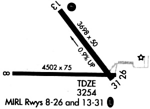
| Runways: | 08/26 13/31 |
| Longest Runway: | 08/26 is 5102 ft (1555 m) long |
| Runways with an Instrument Approach: |
OGA Airport Runway Details
| Runway 08/26 | 5102 ft x 75 ft (1555 m x 23 m) | |
| Runway Length Source: | 3RD PARTY SURVEY as of 08/22/2012 | |
| Surface: | Concrete - Good condition - No special surface treatment | |
| Runway Edge Lights: | Medium Intensity | |
Runway Weight Bearing Capacity (in thousands of pounds) |
||
| Single Wheel Landing Gear: | 12.5 | |
| Dual Wheel Landing Gear: | 12.5 | |
Runway 08 |
Runway 26 |
|
Elevation: |
3260.4 | 3245.0 |
Latitude: |
41-07-04.0732N | 41-07-04.1383N |
Longitude: |
101-46-52.1168W | 101-45-45.4681W |
|
Runway True Alignment: |
090 | 270 |
Glide Path Angle: |
3.0 degrees | 3.0 degrees |
Traffic Pattern: |
Left | Left |
Runway Markings Type: |
Nonprecision Instrument | Nonprecision Instrument |
Runway Markings Condition: |
Good | Good |
Object at End: |
OTHER | POLE |
Object Height: |
11 | 38 |
Distance from End: |
622 | 1550 |
Object Centerline Offset: |
0 ft. left and right of centerline | 0 ft. left and right of centerline |
Visual Glide Slope Indicators: |
2-Light PAPI On Left Side Of Runway | 2-Light PAPI On Left Side Of Runway |
Threshold Crossing Height: |
39 | 48 |
| Runway 13/31 | 3700 ft x 60 ft (1128 m x 18 m) | |
| Runway Length Source: | 3RD PARTY SURVEY as of 08/22/2012 | |
| Surface: | Concrete - Good condition - No special surface treatment | |
| Runway Edge Lights: | Medium Intensity | |
Runway Weight Bearing Capacity (in thousands of pounds) |
||
| Single Wheel Landing Gear: | 12.5 | |
| Dual Wheel Landing Gear: | 12.5 | |
Runway 13 |
Runway 31 |
|
Elevation: |
3279.3 | 3244.8 |
Latitude: |
41-07-33.1819N | 41-07-03.5409N |
Longitude: |
101-46-14.2064W | 101-45-45.9196W |
|
Runway True Alignment: |
144 | 324 |
Glide Path Angle: |
3.5 degrees | 3.0 degrees |
Traffic Pattern: |
Left | Left |
Runway Markings Type: |
Nonprecision Instrument | Nonprecision Instrument |
Runway Markings Condition: |
Good | Good |
Object at End: |
ROAD | POLE |
Object Height: |
30 | 19 |
Distance from End: |
670 | 650 |
Object Centerline Offset: |
0 ft. left and right of centerline | 0 ft. left and right of centerline |
Visual Glide Slope Indicators: |
4-Box VASI On Left Side Of Runway | 2-Light PAPI On Left Side Of Runway |
Threshold Crossing Height: |
40 | 40 |
Services
Airframe Repair: |
Major |
Powerplant Repair: |
Major |
Bottled Oxygen: |
None |
Bulk Oxygen: |
None |
Fuel Available: |
100LL |
Landing Fees: |
No |
Parking: |
Hangars and tiedowns available |
Maps & Diagrams
OGA Sectional
Flight Planning
at skyvector.com
at skyvector.com