Location
Latitude: |
35-21-23.9010N (35.356639) |
Longitude: |
089-52-13.5490W (-89.87043) |
Elevation: |
322.4 feet MSL (98 m MSL) |
Magnetic Variation: |
1.9 W (as of April 2024 from WMM2020 model) |
Time Zone: |
UTC -6.0 (Standard Time) UTC -5.0 (Daylight Savings Time) |
From City: |
01 N.M. NE of Millington, Tennessee |
Found On: |
Memphis Chart |
FAA Region: |
ASO |
Contacts
Manager: |
Publicly owned: |
| MR. ROY REMINGTON 8182 HORNET AVE MILLINGTON, TN 38053 901-872-7495 |
MILLINGTON ARPT AUTH 8182 HORNET AVE MILLINGTON, TN 38053 901-872-7495 |
Operations
Airport Status: |
Operational |
Facility Use: |
Public |
Type: |
Airport |
Activation Date: |
12/1974 |
Control tower: |
Yes |
Attendance (Months/Days/Hours): |
Months/Days/Hours ALL/MON-FRI/0730-0200 |
Boundary ARTCC: |
ZME (Memphis) |
Responsible ARTCC: |
ZME (Memphis) |
Lighting Schedule: |
SEE RMK |
Segmented Circle Indicator: |
Yes |
Traffic Pattern Altitude (MSL): |
1322 feet (403 m) |
NOTAMs Facility: |
NQA |
NOTAM-D Service: |
Yes |
Military Landing Rights: |
Yes |
Civil/Military Joint Use: |
No |
Aircraft Rescue and Firefighting: |
Class IV ARFF Index: A Air Carrier Service: Not Scheduled Certification Date: 12/1995 |
Based Aircraft
| Single Engine: | 52 |
| Multi Engine: | 7 |
| Jet Engine: | 1 |
| GA Helicopters: | 4 |
Annual Operations (as of 06/30/2023)
| Total Operations: | 32226 | |
| Commercial: | 2 | 0.0% |
| Air Taxi: | 596 | 1.8% |
| GA Local: | 13992 | 43.4% |
| GA Itinerant: | 15063 | 46.7% |
| Military Aircraft: | 2573 | 8.0% |
Communications
| CTAF: | 120.250 |
| Unicom: | 122.950 |
| Tower: | MILLINGTON 120.25 340.2 360.2 Hrs: 0900-0200 MON; 0530-0200 TUE-FRI; 0530-1900 SAT-SUN |
| Ground: | 121.375 |
| Approach: | MEMPHIS |
| Departure: | MEMPHIS |
| AWOS-3: | 118.925 (901-873-3630) |
Fixed Based Operators (FBOs) & Fuel
(Click on a business for detail)
Please help us keep this information up to date. This is a FREE SERVICE just like everything else on Airport Guide! If you see that a business needs to be added, modified, or deleted please fill out our Update Form.
To add, modify, or delete a business click here.
Please help us keep this information up to date. This is a FREE SERVICE just like everything else on Airport Guide! If you see that a business needs to be added, modified, or deleted please fill out our Update Form.
Area Code: 901 |
| Business Name | Frequency | Phone | Fuel Grade |
|---|---|---|---|
| Millington Aviation Services, Inc.
Update FBO info |
873-1818, 800-872-8771 | 100LL, Jet A |
Flight Service Stations
| Primary | Alternate | |
| FSS on Field: | N | |
| FSS Name (ID): | Jackson(MKL) | |
| Frequency: | ||
| Toll Free Phone: | 1-800-WX-BRIEF |
Instrument Procedures / Charts
FAA Terminal Procedures valid from 0901Z 03/21/24 to 0901Z 04/18/24.
There are various types of charts available for an airport. They are listed in the Page Type column. Here is a legend for those types:
APD - Airport Diagram
DP - Departure Procedure Charts
HOT - Hot Spots
IAP - Instrument Approach Procedure Charts
MIN - Minimums
STAR - Standard Terminal Arrival Charts
| Page Type | Page Name | Volume | Action Since Last Cycle |
|---|---|---|---|
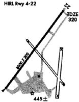
| APD | AIRPORT DIAGRAM | SE-1 | |
| IAP | ILS OR LOC RWY 22 | SE-1 | |
| IAP | RNAV (GPS) RWY 04 | SE-1 | |
| IAP | RNAV (GPS) RWY 22 | SE-1 | |
| IAP | VOR OR TACAN RWY 22 | SE-1 | |
| MIN | ALTERNATE MINIMUMS | SE-1 | |
| MIN | TAKEOFF MINIMUMS | SE-1 |
Terminal Procedures are only available for airports in several countries with more being added all the time. If you are looking for a specific country's charts, please send an email to support(at)airportguide.com stating the country name. This will be used to prioritize the implementation.
Navigation Aids (Navaids) near NQA
| Dist (NM) | ID | Morse Code | Name | Type | Freq | True Hdg | Mag Hdg |
|---|---|---|---|---|---|---|---|
| 5.5 | MIG | _ _ . . _ _ . | Millington | NDB | 232 | 213 | 215 |
| 12.9 | SPQ | . . . . _ _ . _ _ . _ | Spain | NDB | 414 | 223 | 225 |
| 19.2 | MEM | _ _ . _ _ | Memphis Metropolitn | VOT | 111.00 | 196 | 198 |
| 19.7 | COO | _ . _ . _ _ _ _ _ _ | Covington | NDB | 326 | 44 | 46 |
| 20.3 | ME | _ _ . | Elvis | NDB | 287 | 209 | 211 |
| 21.2 | MEM | _ _ . _ _ | Memphis | VORTAC | 117.50 | 195 | 197 |
| 25.1 | FYE | . . _ . _ . _ _ . | Somerville | NDB | 255 | 111 | 113 |
| 29.7 | GQE | _ _ . _ _ . _ . | Gilmore | VOR-DME | 113.00 | 269 | 271 |
| 35.8 | GOJ | _ _ . _ _ _ . _ _ _ | Gosnell | VOR | 111.80 | 354 | 356 |
| 39.7 | HLI | . . . . . _ . . . . | Holly Springs | VORTAC | 112.40 | 152 | 154 |
| 45.7 | MKL | _ _ _ . _ . _ . . | Mersy | NDB | 394 | 77 | 79 |
| 46.8 | JBR | . _ _ _ _ . . . . _ . | Jonesboro | VOR-DME | 115.85 | 311 | 313 |
| 48.0 | DYR | _ . . _ . _ _ . _ . | Dyersburg | TACAN | 116.80 | 33 | 35 |
| 49.2 | MKL | _ _ _ . _ . _ . . | Mc Kellar | VOR-DME | 112.00 | 72 | 74 |
| 59.5 | UV | . . _ . . . _ | Tunng | NDB | 426 | 168 | 170 |
| 61.3 | UJM | . . _ . _ _ _ _ _ | Marvell | VOR-DME | 109.60 | 220 | 222 |
| 64.8 | UU | . . _ . . _ | Seyer | NDB | 334 | 108 | 110 |
| 66.7 | SZY | . . . _ _ . . _ . _ _ | Sibley | NDB | 386 | 95 | 97 |
| 69.5 | ARG | . _ . _ . _ _ . | Walnut Ridge | VORTAC | 114.50 | 310 | 312 |
| 70.7 | UC | . . _ _ . _ . | Obion | NDB | 212 | 36 | 38 |
Nearby Airports with Fuel
Notices to Airmen (NOTAMS)
Remarks
| A110-3 | CAT C AFLD. |
| A110-4 | TWY B CLSD TO ACR. |
| A110-6 | FOR CD WHEN ATCT IS CLSD CTC MEM APCH AT 901-842-8457. |
| A17 | SVC AFT HR - 901-873-4359. |
| A26 | ARPT CLSD TO UNSKED ACR OPS WITH MORE THAN 30 PAX SEATS. ARFF NOT AVBL MON 1130-0300Z; TUE-SAT 0800-1130Z; SAT-SUN 2000-1130Z EXC PPR. INDEX D ARFF AVBL PPR - 901-873-5792. |
| A70-FUEL-10 | 0LL JASU AVBL. |
| A81-APT | ACTVT MALSR RWY 22; REIL RWY 04; HIRL RWY 04/22 - CTAF. HIRL RWY 04/22 PRESET LOW INTST; INCR INTST - CTAF. PAPI RWY 04 & 22 ON CONSLY. |
Runways
Runway Summary
| Runways: | 04/22 |
| Longest Runway: | 04/22 is 8000 ft (2438 m) long |
| Runways with an Instrument Approach: | 22 |
NQA Airport Runway Details
| Runway 04/22 | 8000 ft x 200 ft (2438 m x 61 m) | |
| Runway Length Source: | 3RD PARTY SURVEY as of 11/30/2020 | |
| Surface: | Asphalt - Good condition - No special surface treatment | |
| Runway Pavement Class: | 56 /F/C/W/T | |
| Runway Edge Lights: | High Intensity | |
Runway 04 |
Runway 22 |
|
Elevation: |
277.3 | 322.4 |
Latitude: |
35-20-53.1099N | 35-21-54.6871N |
Longitude: |
089-52-43.8686W | 089-51-43.2219W |
|
Runway True Alignment: |
039 | 219 |
ILS Type: |
ILS/DME | |
Glide Path Angle: |
3.0 degrees | 3.0 degrees |
Traffic Pattern: |
Right | |
Runway Markings Type: |
Precision Instrument | Precision Instrument |
Runway Markings Condition: |
Good | Good |
Visual Glide Slope Indicators: |
4-Light PAPI On Left Side Of Runway | 4-Light PAPI On Left Side Of Runway |
Approach Light System: |
1,400 Foot Medium Intensity Approach Lighting System With Runway Alignment Indicator Lights | |
REIL: |
Yes | No |
Threshold Crossing Height: |
77 | 67 |
Services
Bottled Oxygen: |
None |
Bulk Oxygen: |
None |
Fuel Available: |
100LL |
Landing Fees: |
No |
Parking: |
Tiedowns available |
Maps & Diagrams
NQA Sectional
Flight Planning
at skyvector.com
at skyvector.com