Location
Latitude: |
39-40-02.9000N (39.667472) |
Longitude: |
074-45-27.8000W (-74.757722) |
Elevation: |
64.6 feet MSL (20 m MSL) |
Magnetic Variation: |
12.1 W (as of April 2024 from WMM2020 model) |
Time Zone: |
UTC -5.0 (Standard Time) UTC -4.0 (Daylight Savings Time) |
From City: |
03 N.M. NE of Hammonton, New Jersey |
Found On: |
Washington Chart |
FAA Region: |
AEA |
Contacts
Manager: |
Publicly owned: |
| FRANK ZUBER TOWN HALL, 100 CENTRAL AVENUE HAMMONTON, NJ 08037 (609) 567-4300 |
TOWN OF HAMMONTON TOWN HALL, 100 CENTRAL AVENUE HAMMONTON, NJ 08037 (609) 567-4300 |
Operations
Airport Status: |
Operational |
Facility Use: |
Public |
Type: |
Airport |
Activation Date: |
12/1969 |
Control tower: |
No |
Attendance (Months/Days/Hours): |
Months/Days/Hours ALL/ALL/0800-DUSK |
Boundary ARTCC: |
ZNY (New York) |
Responsible ARTCC: |
ZDC (Washington) |
Lighting Schedule: |
SEE RMK |
Segmented Circle Indicator: |
No |
Traffic Pattern Altitude (MSL): |
1065 feet (325 m) |
NOTAMs Facility: |
MIV |
NOTAM-D Service: |
Yes |
International Airport of Entry: |
No |
Customs Landing Rights: |
No |
Military Landing Rights: |
Yes |
Civil/Military Joint Use: |
No |
Based Aircraft
| Single Engine: | 13 |
| Multi Engine: | 10 |
| GA Helicopters: | 9 |
Annual Operations (as of 10/31/2023)
| Total Operations: | 22525 | |
| GA Local: | 11250 | 49.9% |
| GA Itinerant: | 11275 | 50.1% |
Communications
| CTAF: | 122.700 |
| Unicom: | 122.700 |
| Approach: | ATLANTIC CITY 134.25 134.25 |
| Departure: | ATLANTIC CITY 134.25 134.25 |
| AWOS-AV: | 122.7 |
Fixed Based Operators (FBOs) & Fuel
(Click on a business for detail)
Please help us keep this information up to date. This is a FREE SERVICE just like everything else on Airport Guide! If you see that a business needs to be added, modified, or deleted please fill out our Update Form.
To add, modify, or delete a business click here.
Please help us keep this information up to date. This is a FREE SERVICE just like everything else on Airport Guide! If you see that a business needs to be added, modified, or deleted please fill out our Update Form.
Area Code: 609 |
| Business Name | Frequency | Phone | Fuel Grade |
|---|---|---|---|
| Eastern Aero Supply, Inc.
Update FBO info |
567-9008, 800-257-8148 | ||
| M & D Services, Inc.
Update FBO info |
Unicom 122.7 | 561-0100 | 100LL, Jet A |
Flight Service Stations
| Primary | Alternate | |
| FSS on Field: | N | |
| FSS Name (ID): | Millville(MIV) | |
| Frequency: | ||
| Toll Free Phone: | 1-800-WX-BRIEF |
Instrument Procedures / Charts
FAA Terminal Procedures valid from 0901Z 03/21/24 to 0901Z 04/18/24.
There are various types of charts available for an airport. They are listed in the Page Type column. Here is a legend for those types:
APD - Airport Diagram
DP - Departure Procedure Charts
HOT - Hot Spots
IAP - Instrument Approach Procedure Charts
MIN - Minimums
STAR - Standard Terminal Arrival Charts
| Page Type | Page Name | Volume | Action Since Last Cycle |
|---|---|---|---|
| IAP | RNAV (GPS) RWY 03 | NE-2 | |
| IAP | VOR-B | NE-2 | |
| MIN | TAKEOFF MINIMUMS | NE-2 |
Terminal Procedures are only available for airports in several countries with more being added all the time. If you are looking for a specific country's charts, please send an email to support(at)airportguide.com stating the country name. This will be used to prioritize the implementation.
Navigation Aids (Navaids) near N81
| Dist (NM) | ID | Morse Code | Name | Type | Freq | True Hdg | Mag Hdg |
|---|---|---|---|---|---|---|---|
| 12.4 | VCN | . . . _ _ . _ . _ . | Cedar Lake | VOR-DME | 115.20 | 231 | 243 |
| 15.2 | ACY | . _ _ . _ . _ . _ _ | Atlantic City | VORTAC | 108.60 | 146 | 158 |
| 17.5 | CYN | _ . _ . _ . _ _ _ . | Coyle | VORTAC | 113.40 | 59 | 71 |
| 21.8 | GXU | _ _ . _ . . _ . . _ | Mc Guire | VORTAC | 110.60 | 19 | 31 |
| 23.0 | RNB | . _ . _ . _ . . . | Rainbow | NDB | 363 | 229 | 241 |
| 25.0 | PHL | . _ _ . . . . . . _ . . | Philadelphia | VOT | 109.80 | 298 | 310 |
| 25.3 | OOD | _ _ _ _ _ _ _ . . | Woodstown | VORTAC | 112.80 | 265 | 277 |
| 27.4 | PNE | . _ _ . _ . . | North Philadelphia | VOR | 112.00 | 335 | 347 |
| 29.0 | NEL | _ . . . _ . . | Lakehurst | TACAN | 111.80 | 39 | 51 |
| 29.8 | NEL | _ . . . _ . . | Lakehurst | NDB | 396 | 40 | 52 |
| 34.3 | RBV | . _ . _ . . . . . . _ | Robbinsville | VORTAC | 113.80 | 20 | 32 |
| 34.4 | SIE | . . . . . . | Sea Isle | VORTAC | 114.80 | 183 | 195 |
| 35.8 | ARD | . _ . _ . _ . . | Yardley | VOR-DME | 108.20 | 348 | 360 |
| 36.7 | ING | . . _ . _ _ . | Ambler | NDB | 275 | 318 | 330 |
| 39.2 | DQO | _ . . _ _ . _ _ _ _ | Dupont | VORTAC | 114.00 | 271 | 283 |
| 39.9 | IL | . . . _ . . | Hadin | NDB | 248 | 262 | 274 |
| 43.8 | ENO | . _ . _ _ _ | Smyrna | VORTAC | 111.40 | 233 | 245 |
| 44.7 | MXE | _ _ _ . . _ . | Modena | VORTAC | 113.20 | 289 | 301 |
| 46.0 | DOV | _ . . _ _ _ . . . _ | Dover | TACAN | 110.00 | 225 | 237 |
| 47.4 | COL | _ . _ . _ _ _ . _ . . | Colts Neck | VOR-DME | 115.40 | 35 | 47 |
Nearby Airports with Fuel
Notices to Airmen (NOTAMS)
Remarks
| A110-10 | GCO AVBL ON FREQ 121.725. |
| A110-7 | ON ARPT MAINT CTC 609-567-5300. |
| A110-8 | RWY 03; PARALLEL DITCH FIRST 500 FT OF RWY R SIDE WITHIN 100 FT OF CTLN. |
| A110-9 | DEER & BIRDS ON & INVOF ARPT. |
| A13 | EXT 121. |
| A16 | EXT 121. |
| A52-03 | TALL TREES ON APCH. |
| A58-03 | +30 FT TREES 190-240 FT L 70-170 FT FROM THLD. |
| A58-21 | +50 FT TREES 150 FT R 0-200 FT FROM THLD. |
| A81-APT | ACTVT REIL RWY 03 & 21; MIRL RWY 03/21 - 123.5. VGSI CONS. |
| A82 | AUTOMATED UNICOM; 3 CLICKS WX ADZY. |
Runways
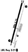
Runway Summary
| Runways: | 03/21 |
| Longest Runway: | 03/21 is 3601 ft (1098 m) long |
| Runways with an Instrument Approach: |
N81 Airport Runway Details
| Runway 03/21 | 3601 ft x 75 ft (1098 m x 23 m) | |
| Runway Length Source: | 3RD PARTY SURVEY as of 09/26/2013 | |
| Surface: | Asphalt - Good condition - No special surface treatment | |
| Runway Edge Lights: | Medium Intensity | |
Runway Weight Bearing Capacity (in thousands of pounds) |
||
| Single Wheel Landing Gear: | 12.0 | |
Runway 03 |
Runway 21 |
|
Elevation: |
64.1 | 57.5 |
Latitude: |
39-39-45.8021N | 39-40-19.9850N |
Longitude: |
074-45-34.2258W | 074-45-21.4316W |
|
Runway True Alignment: |
016 | 196 |
Glide Path Angle: |
3.5 degrees | 3.2 degrees |
Traffic Pattern: |
Left | Left |
Runway Markings Type: |
Nonprecision Instrument | Nonprecision Instrument |
Runway Markings Condition: |
Fair | Fair |
Object at End: |
TREES | TREES |
Object Height: |
61 | 40 |
Distance from End: |
725 | 210 |
Object Centerline Offset: |
270 ft. right of centerline | 150 ft. right of centerline |
Visual Glide Slope Indicators: |
2-Light PAPI On Left Side Of Runway | 2-Light PAPI On Left Side Of Runway |
REIL: |
Yes | Yes |
Touchdown Lights: |
No | No |
Centerline Lights: |
No | No |
Threshold Crossing Height: |
25 | 20 |
Services
Airframe Repair: |
Minor |
Powerplant Repair: |
Minor |
Bottled Oxygen: |
None |
Bulk Oxygen: |
None |
Fuel Available: |
100LL, Jet A |
Landing Fees: |
No |
Parking: |
Hangars and tiedowns available |
Maps & Diagrams
N81 Sectional
Flight Planning
at skyvector.com
at skyvector.com