Location
Latitude: |
32-30-38.0010N (32.510556) |
Longitude: |
092-02-10.0810W (-92.036134) |
Elevation: |
78.9 feet MSL (24 m MSL) |
Magnetic Variation: |
0.3 W (as of April 2024 from WMM2020 model) |
Time Zone: |
UTC -6.0 (Standard Time) UTC -5.0 (Daylight Savings Time) |
From City: |
03 N.M. E of Monroe, Louisiana |
Found On: |
Memphis Chart |
FAA Region: |
ASW |
Contacts
Manager: |
Publicly owned: |
| CHARLES BUTCHER 5400 OPERATIONS RD MONROE, LA 71203 318-329-2460 |
CITY OF MONROE PO BOX 123 MONROE, LA 71210 318-329-2200 |
Operations
Airport Status: |
Operational |
Facility Use: |
Public |
Type: |
Airport |
Activation Date: |
04/1940 |
Control tower: |
Yes |
Attendance (Months/Days/Hours): |
Months/Days/Hours ALL/ALL/ALL |
Boundary ARTCC: |
ZFW (Fort Worth) |
Responsible ARTCC: |
ZFW (Fort Worth) |
Lighting Schedule: |
SEE RMK |
Segmented Circle Indicator: |
Yes |
Traffic Pattern Altitude (MSL): |
1079 feet (329 m) |
NOTAMs Facility: |
MLU |
NOTAM-D Service: |
Yes |
International Airport of Entry: |
No |
Customs Landing Rights: |
No |
Military Landing Rights: |
Yes |
Civil/Military Joint Use: |
No |
Aircraft Rescue and Firefighting: |
Class I ARFF Index: B Air Carrier Service: Scheduled Certification Date: 05/1973 |
Based Aircraft
| Single Engine: | 35 |
| Multi Engine: | 8 |
| Jet Engine: | 6 |
| GA Helicopters: | 1 |
Annual Operations (as of 12/31/2021)
| Total Operations: | 35781 | |
| Commercial: | 227 | 0.6% |
| Air Taxi: | 5917 | 16.5% |
| GA Local: | 9506 | 26.6% |
| GA Itinerant: | 12997 | 36.3% |
| Military Aircraft: | 7134 | 19.9% |
Communications
| CTAF: | 118.900 |
| Unicom: | 122.950 |
| Tower: | MONROE 118.9 257.8 Hrs: 0600-2200 |
| Clearance Del.: | 121.65 |
| Ground: | 121.9 |
| Approach: | MONROE 118.15 ;WITHIN 20 NM BLW 4000 FT 126.9 290.475 ;WITHIN 20 NM BLW 4000 FT 307.9 Hrs: 0600-2200 FORT WORTH ARTCC Hrs: 2200-0600 |
| Departure: | MONROE 118.15 ;WITHIN 20 NM BLW 4000 FT 126.9 290.475 ;WITHIN 20 NM BLW 4000 FT 307.9 Hrs: 0600-2200 FORT WORTH ARTCC Hrs: 2200-0600 |
| ATIS: | 125.05 Hrs: 24 |
| ASOS: | (318-327-5675) |
| EMERG: | 243.0 |
| TRSA: | 118.15 ;WITHIN 20 NM BLW 4000 FT |
| EMERG: | 121.5 |
| TRSA: | 290.475 ;WITHIN 20 NM BLW 4000 FT |
| TRSA: | 307.9 |
| TRSA: | 126.9 |
- APCH/DEP CTL SVC PRVDD BY FORT WORTH ARTCC (ZFW) ON FREQS 126.325/346.25 (MONROE RCAG) WHEN MONROE APCH CTL (MLU) CLSD.
Fixed Based Operators (FBOs) & Fuel
(Click on a business for detail)
Please help us keep this information up to date. This is a FREE SERVICE just like everything else on Airport Guide! If you see that a business needs to be added, modified, or deleted please fill out our Update Form.
To add, modify, or delete a business click here.
Please help us keep this information up to date. This is a FREE SERVICE just like everything else on Airport Guide! If you see that a business needs to be added, modified, or deleted please fill out our Update Form.
Area Code: 318 |
| Business Name | Frequency | Phone | Fuel Grade |
|---|---|---|---|
| Legacy Aviation, Inc.
Update FBO info |
Unicom 122.95, Arinc 130.57 | 387-0222, 800-223-3895 | 100LL, Jet A |
| Mc Mahan Aviation
Update FBO info |
Unicom 123.5 | 325-7558 | 100LL, Jet A |
Flight Service Stations
| Primary | Alternate | |
| FSS on Field: | N | |
| FSS Name (ID): | De Ridder(DRI) | |
| Frequency: | ||
| Toll Free Phone: | 1-800-WX-BRIEF |
Instrument Procedures / Charts
FAA Terminal Procedures valid from 0901Z 03/21/24 to 0901Z 04/18/24.
There are various types of charts available for an airport. They are listed in the Page Type column. Here is a legend for those types:
APD - Airport Diagram
DP - Departure Procedure Charts
HOT - Hot Spots
IAP - Instrument Approach Procedure Charts
MIN - Minimums
STAR - Standard Terminal Arrival Charts
| Page Type | Page Name | Volume | Action Since Last Cycle |
|---|---|---|---|
| APD | AIRPORT DIAGRAM | SC-4 | |
| IAP | ILS OR LOC RWY 04 | SC-4 | |
| IAP | ILS OR LOC RWY 22 | SC-4 | |
| IAP | RNAV (GPS) RWY 04 | SC-4 | |
| IAP | RNAV (GPS) RWY 14 | SC-4 | |
| IAP | RNAV (GPS) RWY 22 | SC-4 | |
| IAP | RNAV (GPS) RWY 32 | SC-4 | |
| IAP | VOR RWY 22 | SC-4 | |
| IAP | VOR RWY 32 | SC-4 | |
| IAP | VOR/DME RWY 04 | SC-4 | |
| MIN | ALTERNATE MINIMUMS | SC-4 | |
| MIN | RADAR MINIMUMS | SC-4 | |
| MIN | TAKEOFF MINIMUMS | SC-4 |
Terminal Procedures are only available for airports in several countries with more being added all the time. If you are looking for a specific country's charts, please send an email to support(at)airportguide.com stating the country name. This will be used to prioritize the implementation.
Navigation Aids (Navaids) near MLU
| Dist (NM) | ID | Morse Code | Name | Type | Freq | True Hdg | Mag Hdg |
|---|---|---|---|---|---|---|---|
| 0.4 | MLU | _ _ . _ . . . . _ | Monroe | VORTAC | 117.20 | 1 | 1 |
| 4.8 | ML | _ _ . _ . . | Sabar | NDB | 392 | 225 | 225 |
| 14.4 | MRK | _ _ . _ . _ . _ | Molly Ridge | NDB | 338 | 114 | 114 |
| 16.6 | BQP | _ . . . _ _ . _ . _ _ . | Bastrop | NDB | 329 | 27 | 27 |
| 28.5 | ROQ | . _ . _ _ _ _ _ . _ | Ruston | NDB | 368 | 282 | 282 |
| 28.7 | TUF | _ . . _ . . _ . | Stuckey | NDB | 350 | 257 | 257 |
| 39.4 | JBL | . _ _ _ _ . . . . _ . . | Hodge | NDB | 256 | 242 | 242 |
| 45.8 | SWB | . . . . _ _ _ . . . | Sawmill | VOR-DME | 113.75 | 225 | 225 |
| 46.8 | BLE | _ . . . . _ . . . | Lake Providence | NDB | 278 | 65 | 66 |
| 53.6 | TKH | _ _ . _ . . . . | Tallulah | NDB | 344 | 106 | 107 |
| 57.2 | ELD | . . _ . . _ . . | El Dorado | VOR-DME | 115.50 | 321 | 321 |
| 58.1 | EL | . . _ . . | Lados | NDB | 418 | 323 | 323 |
| 62.0 | HAH | . . . . . _ . . . . | Natchez-Adams County | NDB | 388 | 142 | 143 |
| 65.1 | MON | _ _ _ _ _ _ . | Monticello | DME | 111.6 | 14 | 14 |
| 65.3 | HEZ | . . . . . _ _ . . | Natchez | VOR-DME | 110.00 | 144 | 145 |
| 73.6 | OOC | _ _ _ _ _ _ _ . _ . | Natchitoches | NDB | 407 | 226 | 226 |
| 76.3 | MTQ | _ _ _ _ _ . _ | Metcalf | NDB | 359 | 43 | 44 |
| 78.9 | AEX | . _ . _ . . _ | Alexandria | VORTAC | 116.10 | 197 | 197 |
| 79.2 | EMG | . _ _ _ _ . | Elm Grove | VORTAC | 111.20 | 265 | 265 |
| 80.6 | GLH | _ _ . . _ . . . . . . | Greenville | VOR-DME | 114.25 | 40 | 41 |
Nearby Airports with Fuel
Notices to Airmen (NOTAMS)
Remarks
| A110-1 | TWY E EAST OF RWY 04/22 RESTRICTED TO ACFT WITH WINGSPAN UNDER 90 FT. TWY C TURNAROUND BTN APCH END RWY 22 AND TWY C1 CLSD TO ACFT WINGSPAN MORE THAN 49 FT. TWY C2 CLSD. |
| A110-3 | BIRD ACT ON AND INVOF ARPT. |
| A110-4 | FOR CD WHEN ATCT IS CLSD CTC FORT WORTH ARTCC AT 817-858-7584 |
| A26 | TWYS J & E EAST OF RWY 04/22 NOT AVBL FOR ACR OPNS WITH OVER 9 PSGR SEATS. |
| A81-APT | WHEN ATCT CLSD ACTVT MALSR RWYS 04 & 22; HIRL RWY 04/22; MIRL RWY 14/32; TWY LGTS - CTAF. PAPI RWYS 04, 22, 14 & 32 OPR CONSLY. |
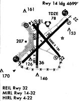
Runways
Runway Summary
| Runways: | 04/22 14/32 |
| Longest Runway: | 04/22 is 7504 ft (2287 m) long |
| Runways with an Instrument Approach: | 04, 22 |
MLU Airport Runway Details
| Runway 04/22 | 7504 ft x 150 ft (2287 m x 46 m) | |
| Runway Length Source: | 3RD PARTY SURVEY as of 10/18/2022 | |
| Surface: | Asphalt - Good condition - Saw-cut or plastic grooved | |
| Runway Pavement Class: | 111/F/D/X/T | |
| Runway Edge Lights: | High Intensity | |
Runway Weight Bearing Capacity (in thousands of pounds) |
||
| Single Wheel Landing Gear: | 75.0 | |
| Dual Wheel Landing Gear: | 170.0 | |
| Dual Tandem Wheel Landing Gear: | 290.0 | |
Runway 04 |
Runway 22 |
|
Elevation: |
75.5 | 74.5 |
Latitude: |
32-30-13.8717N | 32-31-06.3426N |
Longitude: |
092-02-44.3381W | 092-01-42.3371W |
|
Runway True Alignment: |
045 | 225 |
ILS Type: |
ILS | ILS |
Glide Path Angle: |
3.0 degrees | 3.0 degrees |
Traffic Pattern: |
Left | Left |
Runway Markings Type: |
Precision Instrument | Precision Instrument |
Runway Markings Condition: |
Good | Good |
Visual Glide Slope Indicators: |
4-Light PAPI On Left Side Of Runway | 4-Light PAPI On Left Side Of Runway |
Runway Visual Range (RVR): |
Touchdown | Rollout |
Approach Light System: |
1,400 Foot Medium Intensity Approach Lighting System With Runway Alignment Indicator Lights | 1,400 Foot Medium Intensity Approach Lighting System With Runway Alignment Indicator Lights |
Threshold Crossing Height: |
50 | 50 |
Declared Distances |
||
Take Off Run Avbl. (TORA): |
7504 | 7504 |
Take Off Distance Avbl. (TODA): |
7504 | 7504 |
Actual Stop Dist. Avbl. (ASDA): |
7504 | 7504 |
Landing Dist. Avbl. (LDA): |
7504 | 7504 |
| Runway 14/32 | 6301 ft x 150 ft (1921 m x 46 m) | |
| Runway Length Source: | 3RD PARTY SURVEY as of 10/18/2022 | |
| Surface: | Asphalt - Good condition - No special surface treatment | |
| Runway Pavement Class: | 32 /R/C/X/T | |
| Runway Edge Lights: | Medium Intensity | |
Runway Weight Bearing Capacity (in thousands of pounds) |
||
| Single Wheel Landing Gear: | 75.0 | |
| Dual Wheel Landing Gear: | 170.0 | |
| Dual Tandem Wheel Landing Gear: | 290.0 | |
Runway 14 |
Runway 32 |
|
Elevation: |
78.4 | 73.4 |
Latitude: |
32-30-59.3827N | 32-30-11.5980N |
Longitude: |
092-02-29.8343W | 092-01-42.5704W |
|
Runway True Alignment: |
140 | 320 |
Glide Path Angle: |
3.0 degrees | 3.0 degrees |
Traffic Pattern: |
Left | Left |
Runway Markings Type: |
Nonprecision Instrument | Nonprecision Instrument |
Runway Markings Condition: |
Good | Good |
Visual Glide Slope Indicators: |
4-Light PAPI On Left Side Of Runway | 4-Light PAPI On Left Side Of Runway |
REIL: |
Yes | Yes |
Centerline Lights: |
No | No |
Threshold Crossing Height: |
50 | 53 |
Declared Distances |
||
Take Off Run Avbl. (TORA): |
6301 | 6301 |
Take Off Distance Avbl. (TODA): |
6301 | 6301 |
Actual Stop Dist. Avbl. (ASDA): |
6301 | 6301 |
Landing Dist. Avbl. (LDA): |
6301 | 6301 |
Services
Airframe Repair: |
Major |
Powerplant Repair: |
Major |
Bottled Oxygen: |
None |
Bulk Oxygen: |
None |
Fuel Available: |
100LL |
Landing Fees: |
No |
Parking: |
Tiedowns available |
Maps & Diagrams
MLU Sectional
Flight Planning
at skyvector.com
at skyvector.com