Location
Latitude: |
34-52-49.0000N (34.880278) |
Longitude: |
091-10-35.2000W (-91.176444) |
Elevation: |
195.3 feet MSL (60 m MSL) |
Magnetic Variation: |
1 W (as of April 2024 from WMM2020 model) |
Time Zone: |
UTC -6.0 (Standard Time) UTC -5.0 (Daylight Savings Time) |
From City: |
00 N.M. SE of Brinkley, Arkansas |
Found On: |
Memphis Chart |
FAA Region: |
ASW |
Contacts
Manager: |
Publicly owned: |
| TERRY BURNETT 233 WEST CEDAR BRINKLEY, AR 72021 870-734-5059 |
CITY OF BRINKLEY 233 WEST CEDAR BRINKLEY, AR 72021 870-734-1382 |
Operations
Airport Status: |
Operational |
Facility Use: |
Public |
Type: |
Airport |
Activation Date: |
04/1941 |
Control tower: |
No |
Attendance (Months/Days/Hours): |
Months/Days/Hours MAR-SEP/MON-SAT/0800-1700 |
Boundary ARTCC: |
ZME (Memphis) |
Responsible ARTCC: |
ZME (Memphis) |
Lighting Schedule: |
SEE RMK |
Segmented Circle Indicator: |
Yes |
Traffic Pattern Altitude (MSL): |
1195 feet (364 m) |
NOTAMs Facility: |
JBR |
NOTAM-D Service: |
Yes |
International Airport of Entry: |
No |
Customs Landing Rights: |
No |
Military Landing Rights: |
Yes |
Civil/Military Joint Use: |
No |
Based Aircraft
| Single Engine: | 12 |
Annual Operations (as of 01/31/2022)
| Total Operations: | 22100 | |
| GA Local: | 20000 | 90.5% |
| GA Itinerant: | 2000 | 9.0% |
| Military Aircraft: | 100 | 0.5% |
Communications
| CTAF: | 122.800 |
| Unicom: | 122.800 |
- APCH/DEP SVC PRVDD BY MEMPHIS ARTCC ON FREQS 135.3/335.8(BRINKLEY RCAG).
Fixed Based Operators (FBOs) & Fuel
(Click on a business for detail)
Please help us keep this information up to date. This is a FREE SERVICE just like everything else on Airport Guide! If you see that a business needs to be added, modified, or deleted please fill out our Update Form.
To add, modify, or delete a business click here.
Please help us keep this information up to date. This is a FREE SERVICE just like everything else on Airport Guide! If you see that a business needs to be added, modified, or deleted please fill out our Update Form.
Area Code: 870 |
| Business Name | Frequency | Phone | Fuel Grade |
|---|
Flight Service Stations
| Primary | Alternate | |
| FSS on Field: | N | |
| FSS Name (ID): | Jonesboro(JBR) | |
| Frequency: | ||
| Toll Free Phone: | 1-800-WX-BRIEF |
Instrument Procedures / Charts
FAA Terminal Procedures valid from 0901Z 03/21/24 to 0901Z 04/18/24.
There are various types of charts available for an airport. They are listed in the Page Type column. Here is a legend for those types:
APD - Airport Diagram
DP - Departure Procedure Charts
HOT - Hot Spots
IAP - Instrument Approach Procedure Charts
MIN - Minimums
STAR - Standard Terminal Arrival Charts
| Page Type | Page Name | Volume | Action Since Last Cycle |
|---|---|---|---|
| IAP | RNAV (GPS) RWY 20 | SC-1 | |
| MIN | TAKEOFF MINIMUMS | SC-1 |
Terminal Procedures are only available for airports in several countries with more being added all the time. If you are looking for a specific country's charts, please send an email to support(at)airportguide.com stating the country name. This will be used to prioritize the implementation.
Navigation Aids (Navaids) near M36
| Dist (NM) | ID | Morse Code | Name | Type | Freq | True Hdg | Mag Hdg |
|---|---|---|---|---|---|---|---|
| 24.2 | SGT | . . . _ _ . _ | Stuttgart | NDB | 269 | 237 | 238 |
| 30.1 | TT | _ _ | Stutt | NDB | 338 | 221 | 222 |
| 30.8 | UJM | . . _ . _ _ _ _ _ | Marvell | VOR-DME | 109.60 | 126 | 127 |
| 32.2 | DS | _ . . . . . | Cercy | NDB | 375 | 296 | 297 |
| 41.7 | TYV | _ _ . _ _ . . . _ | Toneyville | NDB | 290 | 276 | 277 |
| 44.3 | GQE | _ _ . _ _ . _ . | Gilmore | VOR-DME | 113.00 | 50 | 51 |
| 48.3 | LRF | . _ . . . _ . . . _ . | Jacksonville | TACAN | 109.20 | 272 | 273 |
| 51.0 | LIT | . _ . . . . _ | Little Rock | VORTAC | 113.90 | 256 | 257 |
| 53.1 | PBF | . _ _ . _ . . . . . _ . | Pine Bluff | VOR-DME | 116.00 | 224 | 225 |
| 55.4 | ME | _ _ . | Elvis | NDB | 287 | 78 | 79 |
| 57.1 | LI | . _ . . . . | Lasky | NDB | 353 | 257 | 258 |
| 58.0 | BV | _ . . . . . . _ | Almnd | NDB | 335 | 328 | 329 |
| 58.5 | SPQ | . . . . _ _ . _ _ . _ | Spain | NDB | 414 | 70 | 71 |
| 59.2 | MEM | _ _ . _ _ | Memphis | VORTAC | 117.50 | 81 | 82 |
| 59.6 | MEM | _ _ . _ _ | Memphis Metropolitn | VOT | 111.00 | 79 | 80 |
| 62.7 | CWS | _ . _ . . _ _ . . . | Conway | NDB | 302 | 281 | 282 |
| 65.6 | MIG | _ _ . . _ _ . | Millington | NDB | 232 | 68 | 69 |
| 66.2 | JBR | . _ _ _ _ . . . . _ . | Jonesboro | VOR-DME | 115.85 | 25 | 26 |
| 74.6 | ARG | . _ . _ . _ _ . | Walnut Ridge | VORTAC | 114.50 | 8 | 9 |
| 80.6 | TNZ | _ _ . _ _ . . | Lawrence County | NDB | 227 | 8 | 9 |
Nearby Airports with Fuel
Notices to Airmen (NOTAMS)
Remarks
| A110-1 | WATER-TANK NW. |
| A110-2 | NUMEROUS AGRICULTURAL ACFT OPNS FM FEB-NOV 500 FT AGL AND BELOW. |
| A110-5 | FOR CD CTC MEMPHIS ARTCC AT 901-368-8453/8449. |
| A110-6 | MIGRATORY BIRDS ON & INVOF ARPT |
| A43-02 | PAPI UNUSBL BYD 5 DEGS LEFT OF CNTRLN. |
| A43-20 | PAPI UNUSBL BYD 4 DEGS LEFT OF CNTRLN AND BYD 7 DEGS RIGHT OF CNTRLN. |
| A57-02 | APCH SLOPE 30:1 TO DSPLCD THLD. |
| A57-20 | APCH SLOPE 32:1 TO DSPLCD THLD. |
| A58-02 | ROAD & BRIDGE SIGNS AT 180 FT FM THR XNG CNTRLN. |
| A70-FUEL-10 | 0LL FUEL AVBL 24 HRS SELF SVC WITH CREDIT CARD. |
| A81-APT | ACTVT MIRL RWY 02/20 - CTAF. |
Runways
Runway Summary
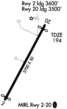
| Runways: | 02/20 |
| Longest Runway: | 02/20 is 4002 ft (1220 m) long |
| Runways with an Instrument Approach: |
M36 Airport Runway Details
| Runway 02/20 | 4002 ft x 75 ft (1220 m x 23 m) | |
| Runway Length Source: | 3RD PARTY SURVEY as of 09/12/2014 | |
| Surface: | Asphalt - Good condition - No special surface treatment | |
| Runway Edge Lights: | Medium Intensity | |
Runway Weight Bearing Capacity (in thousands of pounds) |
||
| Single Wheel Landing Gear: | 12.0 | |
Runway 02 |
Runway 20 |
|
Elevation: |
195.1 | 190.6 |
Latitude: |
34-52-31.1920N | 34-53-06.8249N |
Longitude: |
091-10-45.6345W | 091-10-24.7091W |
|
Runway True Alignment: |
026 | 206 |
Glide Path Angle: |
3.0 degrees | 3.0 degrees |
Traffic Pattern: |
Right | Left |
Runway Markings Type: |
Nonprecision Instrument | Nonprecision Instrument |
Runway Markings Condition: |
Good | Good |
Object at End: |
POLE | TREE |
Object Height: |
25 | 50 |
Distance from End: |
525 | 1250 |
Object Centerline Offset: |
200 ft. left of centerline | 130 ft. right of centerline |
Visual Glide Slope Indicators: |
2-Light PAPI On Left Side Of Runway | 2-Light PAPI On Left Side Of Runway |
Threshold Crossing Height: |
45 | 48 |
Threshold Elevation: |
194.7 | 190.3 |
Displaced Threshold: |
248 | 150 |
Threshold Latitude: |
34-52-33.3997N | 34-53-05.4934N |
Threshold Longitude: |
091-10-44.3384W | 091-10-25.4911W |
Services
Airframe Repair: |
Major |
Powerplant Repair: |
Major |
Bottled Oxygen: |
None |
Bulk Oxygen: |
None |
Fuel Available: |
100LL, Jet A |
Landing Fees: |
No |
Parking: |
Hangars and tiedowns available |
Maps & Diagrams
M36 Sectional
Flight Planning
at skyvector.com
at skyvector.com