Location
Latitude: |
36-46-10.6650N (36.769629) |
Longitude: |
088-35-04.8050W (-88.584668) |
Elevation: |
522.4 feet MSL (159 m MSL) |
Magnetic Variation: |
2.9 W (as of April 2024 from WMM2020 model) |
Time Zone: |
UTC -6.0 (Standard Time) UTC -5.0 (Daylight Savings Time) |
From City: |
03 N.M. NE of Mayfield, Kentucky |
Found On: |
St Louis Chart |
FAA Region: |
ASO |
Contacts
Manager: |
Publicly owned: |
| BRENT ROBERTSON 227 AIRPORT ROAD MAYFIELD, KY 42066 270-247-6878 |
MAYFIELD & GRAVES COUNTY ARPT BOARD 227 AIRPORT ROAD MAYFIELD, KY 42066 (270) 970-2754 |
Operations
Airport Status: |
Operational |
Facility Use: |
Public |
Type: |
Airport |
Activation Date: |
12/1945 |
Control tower: |
No |
Attendance (Months/Days/Hours): |
Months/Days/Hours ALL/ALL/0700-1500 |
Boundary ARTCC: |
ZME (Memphis) |
Responsible ARTCC: |
ZME (Memphis) |
Lighting Schedule: |
SEE RMK |
Segmented Circle Indicator: |
Yes |
Traffic Pattern Altitude (MSL): |
1522 feet (464 m) |
NOTAMs Facility: |
LOU |
NOTAM-D Service: |
Yes |
International Airport of Entry: |
No |
Customs Landing Rights: |
No |
Military Landing Rights: |
Yes |
Civil/Military Joint Use: |
No |
Based Aircraft
| Single Engine: | 14 |
| Multi Engine: | 3 |
| GA Helicopters: | 2 |
Annual Operations (as of 10/17/2019)
| Total Operations: | 15184 | |
| Air Taxi: | 787 | 5.2% |
| GA Local: | 4410 | 29.0% |
| GA Itinerant: | 9462 | 62.3% |
| Military Aircraft: | 525 | 3.5% |
Communications
| CTAF: | 122.800 |
| Unicom: | 122.800 |
| AWOS-3: | 120.625 (270-247-2094) |
- APCH/DEP SVC PRVDD BY MEMPHIS ARTCC ON FREQS 133.65/292.15 (PADUCAH RCAG).
Fixed Based Operators (FBOs) & Fuel
(Click on a business for detail)
Please help us keep this information up to date. This is a FREE SERVICE just like everything else on Airport Guide! If you see that a business needs to be added, modified, or deleted please fill out our Update Form.
To add, modify, or delete a business click here.
Please help us keep this information up to date. This is a FREE SERVICE just like everything else on Airport Guide! If you see that a business needs to be added, modified, or deleted please fill out our Update Form.
Area Code: 270 |
| Business Name | Frequency | Phone | Fuel Grade |
|---|---|---|---|
| Mayfield Aviation, Inc.
Update FBO info |
Unicom 122.8 | 247-6866 | 100LL, Jet A |
Flight Service Stations
| Primary | Alternate | |
| FSS on Field: | N | |
| FSS Name (ID): | Louisville(LOU) | |
| Frequency: | ||
| Toll Free Phone: | 1-800-WX-BRIEF |
Instrument Procedures / Charts
FAA Terminal Procedures valid from 0901Z 03/21/24 to 0901Z 04/18/24.
There are various types of charts available for an airport. They are listed in the Page Type column. Here is a legend for those types:
APD - Airport Diagram
DP - Departure Procedure Charts
HOT - Hot Spots
IAP - Instrument Approach Procedure Charts
MIN - Minimums
STAR - Standard Terminal Arrival Charts
| Page Type | Page Name | Volume | Action Since Last Cycle |
|---|---|---|---|
| IAP | RNAV (GPS) RWY 19 | SE-1 | |
| IAP | RNAV (GPS) Y RWY 01 | SE-1 | |
| IAP | RNAV (GPS) Z RWY 01 | SE-1 | |
| IAP | VOR/DME-A | SE-1 | |
| MIN | ALTERNATE MINIMUMS | SE-1 | |
| MIN | TAKEOFF MINIMUMS | SE-1 |
Terminal Procedures are only available for airports in several countries with more being added all the time. If you are looking for a specific country's charts, please send an email to support(at)airportguide.com stating the country name. This will be used to prioritize the implementation.
Navigation Aids (Navaids) near M25
| Dist (NM) | ID | Morse Code | Name | Type | Freq | True Hdg | Mag Hdg |
|---|---|---|---|---|---|---|---|
| 14.5 | EU | . . . _ | Murey | NDB | 368 | 101 | 104 |
| 18.8 | CNG | _ . _ . _ . _ _ . | Cunningham | VOR-DME | 113.10 | 319 | 322 |
| 22.9 | BDD | _ . . . _ . . _ . . | Bellgrade | NDB | 254 | 349 | 352 |
| 32.3 | TIQ | _ . . _ _ . _ | Trainer | NDB | 410 | 165 | 168 |
| 34.5 | UC | . . _ _ . _ . | Obion | NDB | 212 | 215 | 218 |
| 35.3 | CIR | _ . _ . . . . _ . | Cairo | NDB | 397 | 299 | 302 |
| 37.4 | CHQ | _ . _ . . . . . _ _ . _ | Charleston | NDB | 208 | 277 | 280 |
| 41.3 | HZD | . . . . _ _ . . _ . . | Huntingdon | NDB | 217 | 172 | 175 |
| 52.1 | HXW | . . . . _ . . _ . _ _ | Screaming Eagle | TACAN | 114.90 | 96 | 99 |
| 54.7 | CGI | _ . _ . _ _ . . . | Cape Girardeau | DME | 112.9 | 300 | 303 |
| 56.3 | FK | . . _ . _ . _ | Airbe | NDB | 273 | 91 | 94 |
| 56.5 | AEY | . _ . _ . _ _ | Waverly | NDB | 329 | 133 | 136 |
| 57.1 | CKV | _ . _ . _ . _ . . . _ | Clarksville | VOR-DME | 110.60 | 98 | 101 |
| 57.3 | DYR | _ . . _ . _ _ . _ . | Dyersburg | TACAN | 116.80 | 218 | 221 |
| 59.5 | CK | _ . _ . _ . _ | Snuff | NDB | 335 | 103 | 106 |
| 60.3 | HIX | . . . . . . _ . . _ | Honey Grove | NDB | 356 | 83 | 86 |
| 60.8 | CG | _ . _ . _ _ . | Dutch | NDB | 248 | 298 | 301 |
| 62.5 | MWA | _ _ . _ _ . _ | Marion | DME | 110.4 | 341 | 344 |
| 62.5 | HSB | . . . . . . . _ . . . | Harrisburg-Raleigh | NDB | 230 | 1 | 4 |
| 65.1 | MAW | _ _ . _ . _ _ | Malden | TACAN | 111.20 | 258 | 260 |
Nearby Airports with Fuel
Notices to Airmen (NOTAMS)
Remarks
| A11 | TODD MCBEE - 270-519-5586. |
| A110-1 | FOR CD CTC MEMPHIS ARTCC AT 901-368-8453/8449. |
| A42-01 | FADED & ALGAE COVD. MARKINGS ARE FADED AND ALGAE COVERED |
| A42-19 | FADED & ALGAE COVD. |
| A70-FUEL-10 | 0LL AVBL H24 WITH CREDIT CARD. |
| A81-APT | REIL RWY 01 & 19; PAPI RWY 01 & 19; MIRL RWY 01/19 OPR DUSK-DAWN & ACTVT REIL RWY 01 & 19; PAPI RWY 01 & 19; MIRL RWY 01/19 CTAF. |
| E111 | EXISTED PRIOR TO 1959. |
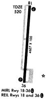
Runways
Runway Summary
| Runways: | 01/19 |
| Longest Runway: | 01/19 is 5002 ft (1525 m) long |
| Runways with an Instrument Approach: |
M25 Airport Runway Details
| Runway 01/19 | 5002 ft x 100 ft (1525 m x 30 m) | |
| Runway Length Source: | 3RD PARTY SURVEY as of 11/18/2021 | |
| Surface: | Asphalt - Fair condition - No special surface treatment | |
| Runway Pavement Class: | 6 /F/D/X/T | |
| Runway Edge Lights: | Medium Intensity | |
Runway Weight Bearing Capacity (in thousands of pounds) |
||
| Single Wheel Landing Gear: | 16.5 | |
Runway 01 |
Runway 19 |
|
Elevation: |
519.2 | 522.3 |
Latitude: |
36-45-46.0132N | 36-46-35.3176N |
Longitude: |
088-35-07.1989W | 088-35-02.4116W |
|
Runway True Alignment: |
004 | 184 |
Glide Path Angle: |
3.0 degrees | 3.0 degrees |
Traffic Pattern: |
Left | Left |
Runway Markings Type: |
Nonprecision Instrument | Nonprecision Instrument |
Runway Markings Condition: |
Poor | Poor |
Object at End: |
FENCE | TREE |
Object Height: |
6 | 65 |
Distance from End: |
270 | 1515 |
Object Centerline Offset: |
229 ft. left of centerline | 291 ft. left of centerline |
Visual Glide Slope Indicators: |
2-Light PAPI On Left Side Of Runway | 4-Light PAPI On Left Side Of Runway |
REIL: |
Yes | Yes |
Threshold Crossing Height: |
41 | 35 |
Services
Fuel Available: |
100LL, Jet A+ |
Landing Fees: |
No |
Parking: |
Hangars and tiedowns available |
Maps & Diagrams
M25 Sectional
Flight Planning
at skyvector.com
at skyvector.com