Location
Latitude: |
39-26-25.5000N (39.440417) |
Longitude: |
083-01-23.0000W (-83.023056) |
Elevation: |
725.0 feet MSL (221 m MSL) |
Magnetic Variation: |
7.1 W (as of April 2024 from WMM2020 model) |
Time Zone: |
UTC -5.0 (Standard Time) UTC -4.0 (Daylight Savings Time) |
From City: |
06 N.M. NW of Chillicothe, Ohio |
Found On: |
Cincinnati Chart |
FAA Region: |
AGL |
Contacts
Manager: |
Publicly owned: |
| JAMES PARKS 1296 STONE RD CHILLICOTHE, OH 45601-9739 740-773-4788 |
ROSS COUNTY BOARD OF COMM 2 N PAINT ST STE H CHILLICOTHE, OH 45601-3109 740-702-3085 |
Operations
Airport Status: |
Operational |
Facility Use: |
Public |
Type: |
Airport |
Activation Date: |
02/1965 |
Control tower: |
No |
Attendance (Months/Days/Hours): |
Months/Days/Hours ALL/ALL/0800-1700 |
Boundary ARTCC: |
ZID (Indianapolis) |
Responsible ARTCC: |
ZID (Indianapolis) |
Lighting Schedule: |
SEE RMK |
Segmented Circle Indicator: |
No |
Traffic Pattern Altitude (MSL): |
1725 feet (526 m) |
NOTAMs Facility: |
DAY |
NOTAM-D Service: |
Yes |
International Airport of Entry: |
No |
Customs Landing Rights: |
No |
Military Landing Rights: |
Yes |
Civil/Military Joint Use: |
No |
Based Aircraft
| Single Engine: | 24 |
| Jet Engine: | 1 |
Annual Operations (as of 09/07/2021)
| Total Operations: | 53750 | |
| Air Taxi: | 550 | 1.0% |
| GA Local: | 39600 | 73.7% |
| GA Itinerant: | 9600 | 17.9% |
| Military Aircraft: | 4000 | 7.4% |
Communications
| CTAF: | 122.800 |
| Unicom: | 122.800 |
| Approach: | COLUMBUS 132.3 ;100-279 132.3 ;100-279 132.3 ;100-279 132.3 ;100-279 |
| Departure: | COLUMBUS 132.3 ;100-279 132.3 ;100-279 132.3 ;100-279 132.3 ;100-279 |
| AWOS-3: | 119.225 (740-779-1364) |
Fixed Based Operators (FBOs) & Fuel
(Click on a business for detail)
Please help us keep this information up to date. This is a FREE SERVICE just like everything else on Airport Guide! If you see that a business needs to be added, modified, or deleted please fill out our Update Form.
To add, modify, or delete a business click here.
Please help us keep this information up to date. This is a FREE SERVICE just like everything else on Airport Guide! If you see that a business needs to be added, modified, or deleted please fill out our Update Form.
Area Code: 740 |
| Business Name | Frequency | Phone | Fuel Grade |
|---|---|---|---|
| T.R.M. Aviation, Inc.
Update FBO info |
Unicom 122.8 | 773-4788 | 100LL, Jet A |
Flight Service Stations
| Primary | Alternate | |
| FSS on Field: | N | |
| FSS Name (ID): | Dayton(DAY) | |
| Frequency: | ||
| Toll Free Phone: | 1-800-WX-BRIEF |
Instrument Procedures / Charts
FAA Terminal Procedures valid from 0901Z 03/21/24 to 0901Z 04/18/24.
There are various types of charts available for an airport. They are listed in the Page Type column. Here is a legend for those types:
APD - Airport Diagram
DP - Departure Procedure Charts
HOT - Hot Spots
IAP - Instrument Approach Procedure Charts
MIN - Minimums
STAR - Standard Terminal Arrival Charts
| Page Type | Page Name | Volume | Action Since Last Cycle |
|---|---|---|---|
| IAP | RNAV (GPS) RWY 23 | EC-2 | |
| IAP | VOR RWY 23 | EC-2 | |
| MIN | ALTERNATE MINIMUMS | EC-2 | |
| MIN | TAKEOFF MINIMUMS | EC-2 |
Terminal Procedures are only available for airports in several countries with more being added all the time. If you are looking for a specific country's charts, please send an email to support(at)airportguide.com stating the country name. This will be used to prioritize the implementation.
Navigation Aids (Navaids) near KRZT
| Dist (NM) | ID | Morse Code | Name | Type | Freq | True Hdg | Mag Hdg |
|---|---|---|---|---|---|---|---|
| 0.3 | RZT | . _ . _ _ . . _ | Ross County | NDB | 236 | 243 | 250 |
| 5.6 | XUB | _ . . _ . . _ _ . . . | Yellow Bud | VOR | 112.50 | 21 | 28 |
| 16.9 | EOP | . _ _ _ . _ _ . | Waverly | NDB | 385 | 165 | 172 |
| 18.2 | DD | _ . . _ . . | Cobbs | NDB | 253 | 0 | 7 |
| 19.6 | CSS | _ . _ . . . . . . . | Court House | NDB | 414 | 299 | 306 |
| 22.5 | LCK | . _ . . _ . _ . _ . _ | Rickenbacker | TACAN | 69X | 11 | 18 |
| 24.2 | BU | _ . . . . . _ | Boutn | NDB | 230 | 339 | 346 |
| 27.8 | LC | . _ . . _ . _ . | Pickl | NDB | 376 | 18 | 25 |
| 28.6 | HOC | . . . . _ _ _ _ . _ . | Hillsboro | NDB | 278 | 237 | 244 |
| 33.3 | IL | . . . _ . . | Airbo | NDB | 407 | 275 | 282 |
| 33.9 | CMH | _ . _ . _ _ . . . . | Port Columbus | VOT | 111.00 | 10 | 17 |
| 34.2 | CHC | _ . _ . . . . . _ . _ . | Grens | NDB | 272 | 359 | 366 |
| 34.2 | PZO | . _ _ . _ _ . . _ _ _ | Peebles | NDB | 329 | 204 | 211 |
| 35.0 | CM | _ . _ . _ _ | Sumie | NDB | 391 | 20 | 27 |
| 36.1 | MXQ | _ _ _ . . _ _ _ . _ | Midwest | VOR-DME | 112.90 | 269 | 276 |
| 38.8 | OS | _ _ _ . . . | Fuler | NDB | 515 | 348 | 355 |
| 39.9 | HW | . . . . . _ _ | Cubla | NDB | 299 | 262 | 269 |
| 40.5 | UNI | . . _ _ . . . | Athens | FAN MARKER | 108 | 115 | |
| 43.0 | UGS | . . _ _ _ . . . . | University | NDB | 250 | 104 | 111 |
| 43.2 | AMT | . _ _ _ _ | West Union | NDB | 359 | 215 | 222 |
Nearby Airports with Fuel
Notices to Airmen (NOTAMS)
Remarks
| A110-1 | FOR CD CTC COLUMBUS APCH AT 614-338-8537. |
| A110-2 | OCNL DEER, BIRDS, & OTR WILDLIFE ON & INVOF ARPT. |
| A14 | TRM@HORIZONVIEW.NET. |
| A17 | UNATNDD: NEW YEAR, JULY 4TH, THANKSGIVING, & CHRISTMAS. |
| A75 | PRIOR CDN RQRD. |
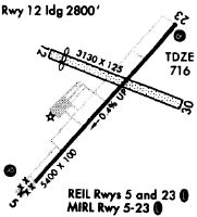
| A81-APT | ACTVT REIL RWY 05 & 23; PAPI RWY 05 & 23; MIRL RWY 05/23 - 123.0. |
Runways
Runway Summary
| Runways: | 05/23 |
| Longest Runway: | 05/23 is 5405 ft (1647 m) long |
| Runways with an Instrument Approach: |
KRZT Airport Runway Details
| Runway 05/23 | 5405 ft x 100 ft (1647 m x 30 m) | |
| Runway Length Source: | 3RD PARTY SURVEY as of 07/06/2012 | |
| Surface: | Asphalt - Good condition - No special surface treatment | |
| Runway Edge Lights: | Medium Intensity | |
Runway Weight Bearing Capacity (in thousands of pounds) |
||
| Single Wheel Landing Gear: | 75.0 | |
| Dual Wheel Landing Gear: | 100.0 | |
Runway 05 |
Runway 23 |
|
Elevation: |
724.9 | 704.5 |
Latitude: |
39-26-05.7815N | 39-26-45.2072N |
Longitude: |
083-01-46.2633W | 083-00-59.7807W |
|
Runway True Alignment: |
042 | 222 |
Glide Path Angle: |
3.0 degrees | 3.0 degrees |
Traffic Pattern: |
Left | Left |
Runway Markings Type: |
Nonprecision Instrument | Nonprecision Instrument |
Runway Markings Condition: |
Fair | Fair |
Object at End: |
TREES | TREES |
Object Height: |
75 | 40 |
Distance from End: |
1510 | 1050 |
Object Centerline Offset: |
215 ft. left of centerline | 380 ft. left of centerline |
Visual Glide Slope Indicators: |
4-Light PAPI On Left Side Of Runway | 4-Light PAPI On Left Side Of Runway |
REIL: |
Yes | Yes |
Threshold Crossing Height: |
44 | 45 |
Services
Bottled Oxygen: |
None |
Bulk Oxygen: |
None |
Fuel Available: |
100LL |
Landing Fees: |
No |
Maps & Diagrams
KRZT Sectional
Flight Planning
at skyvector.com
at skyvector.com