Location
Latitude: |
19-44-19.5540N (19.738765) |
Longitude: |
156-02-44.2720W (-156.045631) |
Elevation: |
48.6 feet MSL (15 m MSL) |
Magnetic Variation: |
9.5 E (as of April 2024 from WMM2020 model) |
Time Zone: |
UTC -10.0 (Standard Time) UTC -10.0 (Daylight Savings Time) |
From City: |
06 N.M. NW of Kailua/Kona, Hawaii |
Found On: |
Hawaiian Islands Chart |
FAA Region: |
AWP |
Contacts
Manager: |
Publicly owned: |
| CHAUNCEY WONG YUEN 73-200 KUPIPI ST, KONA INTL AIRPORT AT KEAHOLE KAILUA-KONA, HI 96740-2645 808-327-9520 |
HAWAII ST ARPTS DIV HONOLULU INTL ARPT HONOLULU, HI 96819 808-838-8600 |
Operations
Airport Status: |
Operational |
Facility Use: |
Public |
Type: |
Airport |
Activation Date: |
01/1971 |
Control tower: |
Yes |
Attendance (Months/Days/Hours): |
Months/Days/Hours ALL/ALL/0600-2200 |
Boundary ARTCC: |
ZHN (Honolulu Control Facility) |
Responsible ARTCC: |
ZHN (Honolulu Control Facility) |
Lighting Schedule: |
SEE RMK |
Segmented Circle Indicator: |
Yes |
Traffic Pattern Altitude (MSL): |
1049 feet (320 m) |
NOTAMs Facility: |
KOA |
NOTAM-D Service: |
Yes |
International Airport of Entry: |
No |
Customs Landing Rights: |
Yes |
Military Landing Rights: |
Yes |
Civil/Military Joint Use: |
No |
Aircraft Rescue and Firefighting: |
Class I ARFF Index: D Air Carrier Service: Scheduled Certification Date: 04/1973 |
Based Aircraft
| Single Engine: | 33 |
| Multi Engine: | 12 |
| GA Helicopters: | 20 |
Annual Operations (as of 12/31/2023)
| Total Operations: | 114370 | |
| Commercial: | 36358 | 31.8% |
| Air Taxi: | 9986 | 8.7% |
| GA Local: | 46216 | 40.4% |
| GA Itinerant: | 17250 | 15.1% |
| Military Aircraft: | 4560 | 4.0% |
Communications
| CTAF: | 120.300 |
| Tower: | KONA 120.3 254.3 Hrs: 0600-2200 |
| Clearance Del.: | 118.6 |
| Ground: | 121.9 |
| Approach: | HCF CENTER |
| Departure: | HCF CENTER |
| ATIS: | 127.4 Hrs: 24 |
| ASOS: | (808-329-0412) |
| EMERG: | 121.5 |
| EMERG: | 243.0 |
- APCH/DEP SVC PRVDD BY HONOLULU CONTROL FACILITY (ZHN) ON FREQS 118.45 (HALEAKALA)/278.3 (MOUNT HALEAKALA RCAG).
Fixed Based Operators (FBOs) & Fuel
(Click on a business for detail)
Please help us keep this information up to date. This is a FREE SERVICE just like everything else on Airport Guide! If you see that a business needs to be added, modified, or deleted please fill out our Update Form.
To add, modify, or delete a business click here.
Please help us keep this information up to date. This is a FREE SERVICE just like everything else on Airport Guide! If you see that a business needs to be added, modified, or deleted please fill out our Update Form.
Area Code: 808 |
| Business Name | Frequency | Phone | Fuel Grade |
|---|---|---|---|
| Bradley Pacific Aviation
Update FBO info |
Arinc 130.8 | 329-4682 | Jet A |
| Century Aviation
Update FBO info |
Unicom 122.95 | 329-8707 | 100LL, Jet A |
| Hawaiian Airlines, Inc.
Update FBO info |
329-2502 | Jet A | |
| KOA Air Service
Update FBO info |
326-2288 | ||
| Mauna Loa Helicopters, Inc.
Website Update FBO info |
334-0234 | 100 | |
| Mokulele Flight Service
Website Update FBO info |
326-7070, 888-584-5002 | ||
| Signature Flight Support
Update FBO info |
Unicom: 130.8, Arinc: 130.8 | +1 808 329 4682 | |
| Sporty's Academy Hawaii
Website Update FBO info |
969-2000, 800-538-7590 |
Flight Service Stations
| Primary | Alternate | |
| FSS on Field: | N | |
| FSS Name (ID): | Honolulu(HNL) | |
| Frequency: | ||
| Toll Free Phone: | 1-800-WX-BRIEF |
Instrument Procedures / Charts
FAA Terminal Procedures valid from 0901Z 03/21/24 to 0901Z 04/18/24.
There are various types of charts available for an airport. They are listed in the Page Type column. Here is a legend for those types:
APD - Airport Diagram
DP - Departure Procedure Charts
HOT - Hot Spots
IAP - Instrument Approach Procedure Charts
MIN - Minimums
STAR - Standard Terminal Arrival Charts
| Page Type | Page Name | Volume | Action Since Last Cycle |
|---|---|---|---|
| APD | AIRPORT DIAGRAM | PC-1 | |
| DP | AMERY FOUR | PC-1 | |
| DP | CRISI TWO (RNAV) | PC-1 | |
| DP | ONIZU ONE (RNAV) | PC-1 | |
| HOT | HOT SPOT | PC-1 | |
| IAP | ILS OR LOC RWY 17 | PC-1 | |
| IAP | LOC BC RWY 35 | PC-1 | |
| IAP | RNAV (GPS) RWY 35 | PC-1 | |
| IAP | RNAV (GPS) Y RWY 17 | PC-1 | |
| IAP | RNAV (RNP) Z RWY 17 | PC-1 | |
| IAP | VOR OR TACAN RWY 17 | PC-1 | |
| IAP | VOR OR TACAN RWY 35 | PC-1 | |
| MIN | ALTERNATE MINIMUMS | PC-1 | |
| MIN | DIVERSE VECTOR AREA | PC-1 | |
| MIN | TAKEOFF MINIMUMS | PC-1 | |
| STAR | KAYAK SIX | PC-1 | |
| STAR | KAYAK SIX[DELIMITER] CONT.1 | PC-1 | |
| STAR | VECKI NINE | PC-1 | |
| STAR | VECKI NINE[DELIMITER] CONT.1 | PC-1 |
Terminal Procedures are only available for airports in several countries with more being added all the time. If you are looking for a specific country's charts, please send an email to support(at)airportguide.com stating the country name. This will be used to prioritize the implementation.
Navigation Aids (Navaids) near KOA
| Dist (NM) | ID | Morse Code | Name | Type | Freq | True Hdg | Mag Hdg |
|---|---|---|---|---|---|---|---|
| 1.3 | KOA | _ . _ _ _ _ . _ | Kona | VORTAC | 112.10 | 178 | 169 |
| 25.5 | BSF | _ . . . . . . . . _ . | Bradshaw | NDB | 339 | 86 | 77 |
| 26.3 | MUE | _ _ . . _ . | Kamuela | VOR-DME | 113.30 | 53 | 44 |
| 30.0 | UPP | . . _ . _ _ . . _ _ . | Upolu Point | VORTAC | 112.30 | 22 | 13 |
| 58.4 | ITO | . . _ _ _ _ | Hilo | VORTAC | 116.90 | 90 | 81 |
| 61.8 | POA | . _ _ . _ _ _ . _ | Pahoa | NDB | 332 | 100 | 91 |
| 72.1 | VYI | . . . _ _ . _ _ . . | Valley Island | NDB | 327 | 342 | 333 |
| 73.2 | OGG | _ _ _ _ _ . _ _ . | Maui | VORTAC | 115.10 | 343 | 334 |
| 80.6 | LNY | . _ . . _ . _ . _ _ | Lanai | VORTAC | 117.70 | 319 | 310 |
| 81.1 | LLD | . _ . . . _ . . _ . . | Lanai | NDB | 353 | 320 | 311 |
Nearby Airports with Fuel
| Dist (NM) | Name (Airport IDs) | True Hdg | Mag Hdg | Fuel Grade |
|---|---|---|---|---|
| 56.3 | Hilo International Airport (ITO PHTO ITO) |
90 | 81 | 100LL, Jet A |
| 72.9 | Kahului Airport (OGG PHOG OGG) |
342 | 333 | 100, Jet A |
| 80.9 | Lanai Airport (LNY PHNY LNY) |
321 | 312 | Jet A |
Notices to Airmen (NOTAMS)
Remarks
| A110-16 | MIGRATORY BIRD ACTIVITY WITHIN A 5 NM RADIUS OF ARPT. |
| A110-17 | ALL WIDE-BODY AIRCRAFT CONTACT ATCT PRIOR TO ENGINE START. |
| A110-19 | DIVISION 1.1, 1.2, 1.3 EXPLOSIVES PROHIBITED. PPR FM ARPT MGR FOR TRANSPORTATION OF DIVISION 1.4 EXPLOSIVES AND HAZARDOUS MATERIAL IN AND OUT OF AIRPORT. |
| A110-20 | JET ACFT ON CARGO AND SOUTH RAMP CTC ATCT PRIOR TO ENGINE START. |
| A110-21 | U.S. CUSTOMS LCTD ON SOUTH RAMP. |
| A110-22 | PUSH BACK/PULL OUT REQUIRED FROM TERMINAL PARKING POSITIONS FOR ALL ACFT, NO POWER OUT. |
| A110-24 | HELICOPTER OPERATIONS ON AND INVOF TWY ALPHA. |
| A110-25 | FOR CD WHEN ATCT IS CLSD CTC HONOLULU CONTROL FACILITY AT 808-840-6262. |
| A110-26 | AP ARFF MNT CTAF 120.3 WHEN ATC CLSD. |
| A110-3 | TPA SMALL ACFT 800' MSL; LARGE ACFT 1500' MSL. |
| A110-4 | REQ FOUR ENG ACFT TAXI WITH OUTBOARD ENGS AT IDLE DUE NARROW TWYS. |
| A110-5 | ALL HELICOPTERS CONFINE OPNS TO PAVED AREAS. |
| A110-6 | PPR FM AMGR FOR TRANSIENT PARKING CALL 808-327-9520. |
| A38-17/35 | DOUBLE DUAL TANDEM WHEEL FOR DC10-10 450000 LBS GWT; B747-SP 700000 LBS GWT; B747-100 850000 LBS GWT. |
| A52-17 | TERRAIN |
| A70-FUEL-10 | 0 JET-A & 100 OCTANE FUEL AVBL DAILY 0800-1700, OTHER TIMES WITH PRIOR ARRANGMENTS, CALL 808-329-4682. |
| A81-APT | ACTVT MALSR RWY 17; HIRL RWY 17/35 & TWY LGTS - CTAF. |
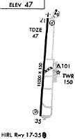
Runways
Runway Summary
| Runways: | 17/35 |
| Longest Runway: | 17/35 is 11000 ft (3353 m) long |
| Runways with an Instrument Approach: | 17 |
KOA Airport Runway Details
| Runway 17/35 | 11000 ft x 150 ft (3353 m x 46 m) | |
| Runway Length Source: | 3RD PARTY SURVEY as of 02/06/2020 | |
| Surface: | Asphalt - Good condition - Saw-cut or plastic grooved | |
| Runway Pavement Class: | 69 /F/A/W/T | |
| Runway Edge Lights: | High Intensity | |
Runway Weight Bearing Capacity (in thousands of pounds) |
||
| Single Wheel Landing Gear: | 75.0 | |
| Dual Wheel Landing Gear: | 200.0 | |
| Dual Tandem Wheel Landing Gear: | 400.0 | |
| Dual Dual Tandem Wheel Landing Gear: | 850.0 | |
Runway 17 |
Runway 35 |
|
Elevation: |
48.6 | 38.0 |
Latitude: |
19-45-13.8786N | 19-43-25.2289N |
Longitude: |
156-02-39.4386W | 156-02-49.1044W |
|
Runway True Alignment: |
185 | 005 |
ILS Type: |
ILS/DME | |
Glide Path Angle: |
3.0 degrees | 3.0 degrees |
Traffic Pattern: |
Right | Left |
Runway Markings Type: |
Precision Instrument | Precision Instrument |
Runway Markings Condition: |
Good | Good |
Object at End: |
OTHER | |
Object Height: |
6 | |
Distance from End: |
400 | |
Object Centerline Offset: |
400 ft. left of centerline | |
Visual Glide Slope Indicators: |
4-Light PAPI On Left Side Of Runway | 4-Light PAPI On Left Side Of Runway |
Approach Light System: |
1,400 Foot Medium Intensity Approach Lighting System With Runway Alignment Indicator Lights | |
REIL: |
No | No |
Touchdown Lights: |
No | No |
Centerline Lights: |
No | No |
Threshold Crossing Height: |
77 | 71 |
Declared Distances |
||
Take Off Run Avbl. (TORA): |
11000 | 11000 |
Take Off Distance Avbl. (TODA): |
11000 | 11000 |
Actual Stop Dist. Avbl. (ASDA): |
11000 | 11000 |
Landing Dist. Avbl. (LDA): |
11000 | 11000 |
Services
Airframe Repair: |
None |
Powerplant Repair: |
None |
Bottled Oxygen: |
None |
Bulk Oxygen: |
None |
Fuel Available: |
Jet A |
Landing Fees: |
No |
Parking: |
Tiedowns available |
Maps & Diagrams
KOA Sectional
Flight Planning
at skyvector.com
at skyvector.com