Location
Latitude: |
45-11-40.4000N (45.194556) |
Longitude: |
123-08-09.8000W (-123.136056) |
Elevation: |
162.6 feet MSL (50 m MSL) |
Magnetic Variation: |
14.8 E (as of April 2024 from WMM2020 model) |
Time Zone: |
UTC -8.0 (Standard Time) UTC -7.0 (Daylight Savings Time) |
From City: |
03 N.M. SE of Mc Minnville, Oregon |
Found On: |
Seattle Chart |
FAA Region: |
ANM |
Contacts
Manager: |
Publicly owned: |
| WILLY WILLIAMSON 4000 SE CIRRUS AVE MC MINNVILLE, OR 97128 (503) 376-0190 |
CITY OF MC MINNVILLE CITY HALL- 230 NORTH EAST SECOND ST MC MINNVILLE, OR 97128 503-434-7312 |
Operations
Airport Status: |
Operational |
Facility Use: |
Public |
Type: |
Airport |
Activation Date: |
12/1943 |
Control tower: |
No |
Attendance (Months/Days/Hours): |
Months/Days/Hours ALL/ALL/1600-0100Z |
Boundary ARTCC: |
ZSE (Seattle) |
Responsible ARTCC: |
ZSE (Seattle) |
Lighting Schedule: |
SEE RMK |
Segmented Circle Indicator: |
Yes |
Traffic Pattern Altitude (MSL): |
1163 feet (354 m) |
NOTAMs Facility: |
MMV |
NOTAM-D Service: |
Yes |
International Airport of Entry: |
No |
Customs Landing Rights: |
No |
Military Landing Rights: |
Yes |
Civil/Military Joint Use: |
No |
Based Aircraft
| Single Engine: | 120 |
| Multi Engine: | 8 |
| Jet Engine: | 2 |
| GA Helicopters: | 20 |
| Gliders: | 4 |
Annual Operations (as of 09/20/2021)
| Total Operations: | 63500 | |
| GA Local: | 22000 | 34.6% |
| GA Itinerant: | 40000 | 63.0% |
| Military Aircraft: | 1500 | 2.4% |
Communications
| CTAF: | 123.000 |
| Unicom: | 123.000 |
| Approach: | PORTLAND 118.1 ;NORTH 118.1 ;NORTH 118.1 ;NORTH 118.1 ;NORTH SEATTLE ARTCC |
| Departure: | PORTLAND 118.1 ;NORTH 118.1 ;NORTH 118.1 ;NORTH 118.1 ;NORTH SEATTLE ARTCC |
| ASOS: | 135.675 (503-434-9153) |
- WHEN APPROACHING FROM OR DEPARTING TO THE SOUTH CONTACT SEATTLE ARTCC ON FREQS 125.8/291.7 (HORTON RCAG).
Fixed Based Operators (FBOs) & Fuel
(Click on a business for detail)
Please help us keep this information up to date. This is a FREE SERVICE just like everything else on Airport Guide! If you see that a business needs to be added, modified, or deleted please fill out our Update Form.
To add, modify, or delete a business click here.
Please help us keep this information up to date. This is a FREE SERVICE just like everything else on Airport Guide! If you see that a business needs to be added, modified, or deleted please fill out our Update Form.
Area Code: 503 |
| Business Name | Frequency | Phone | Fuel Grade |
|---|---|---|---|
| Cascade Soaring
Update FBO info |
472-8805 | ||
| McMinnville Aviation
Update FBO info |
Unicom 123.0 | 472-0558 | 80, 100LL, Jet A |
| Northwest Airmotive
Update FBO info |
472-4790 |
Flight Service Stations
| Primary | Alternate | |
| FSS on Field: | N | |
| FSS Name (ID): | Mc Minnville(MMV) | |
| Frequency: | ||
| Toll Free Phone: | 1-800-WX-BRIEF |
Instrument Procedures / Charts
FAA Terminal Procedures valid from 0901Z 03/21/24 to 0901Z 04/18/24.
There are various types of charts available for an airport. They are listed in the Page Type column. Here is a legend for those types:
APD - Airport Diagram
DP - Departure Procedure Charts
HOT - Hot Spots
IAP - Instrument Approach Procedure Charts
MIN - Minimums
STAR - Standard Terminal Arrival Charts
| Page Type | Page Name | Volume | Action Since Last Cycle |
|---|---|---|---|
| IAP | ILS OR LOC RWY 22 | NW-1 | |
| IAP | RNAV (GPS) RWY 04 | NW-1 | Changed |
| IAP | RNAV (GPS) RWY 22 | NW-1 | |
| IAP | VOR/DME-B | NW-1 | |
| MIN | ALTERNATE MINIMUMS | NW-1 | |
| MIN | DIVERSE VECTOR AREA | NW-1 | |
| MIN | TAKEOFF MINIMUMS | NW-1 |
Terminal Procedures are only available for airports in several countries with more being added all the time. If you are looking for a specific country's charts, please send an email to support(at)airportguide.com stating the country name. This will be used to prioritize the implementation.
Navigation Aids (Navaids) near KMMV
| Dist (NM) | ID | Morse Code | Name | Type | Freq | True Hdg | Mag Hdg |
|---|---|---|---|---|---|---|---|
| 11.6 | UBG | . . _ _ . . . _ _ . | Newberg | VOR-DME | 117.40 | 34 | 19 |
| 22.2 | HIO | . . . . . . _ _ _ | Hillsboro | VOT | 115.20 | 20 | 5 |
| 22.3 | SL | . . . . _ . . | Turno | NDB | 266 | 159 | 144 |
| 26.4 | PND | . _ _ . _ . _ . . | Banks | NDB | 356 | 8 | 353 |
| 32.4 | CBU | _ . _ . _ . . . . . _ | Columbia | TACAN | 109.20 | 42 | 27 |
| 32.7 | PDX | . _ _ . _ . . _ . . _ | Portland | VOR-DME | 111.80 | 42 | 27 |
| 32.9 | PDX | . _ _ . _ . . _ . . _ | Portland | VOT | 111.00 | 42 | 27 |
| 35.2 | LBH | . _ . . _ . . . . . . . | Laker | NDB | 332 | 53 | 38 |
| 35.3 | LWG | . _ . . . _ _ _ _ . | Lewisburg | NDB | 225 | 189 | 174 |
| 40.3 | BTG | _ . . . _ _ _ . | Battle Ground | VORTAC | 116.60 | 34 | 19 |
| 42.2 | CVO | _ . _ . . . . _ _ _ _ | Corvallis | VOR-DME | 115.40 | 189 | 174 |
| 54.1 | ONP | _ _ _ _ . . _ _ . | Newport | VORTAC | 117.10 | 226 | 211 |
| 58.4 | LSO | . _ . . . . . _ _ _ | Kelso | NDB | 256 | 9 | 354 |
| 59.0 | EU | . . . _ | Frakk | NDB | 260 | 183 | 168 |
| 59.8 | PEN | . _ _ . . _ . | Karpen | NDB | 201 | 341 | 326 |
| 64.5 | EUG | . . . _ _ _ . | Eugene | VORTAC | 112.90 | 183 | 168 |
| 65.9 | AST | . _ . . . _ | Astoria | VOR-DME | 114.00 | 331 | 316 |
| 70.1 | AST | . _ . . . _ | Fort Stevens | FAN MARKER | 330 | 315 | |
| 91.1 | LTJ | . _ . . _ . _ _ _ | Klickitat | VOR-DME | 112.30 | 69 | 54 |
| 96.4 | DSD | _ . . . . . _ . . | Deschutes | VORTAC | 117.60 | 125 | 110 |
Nearby Airports with Fuel
Notices to Airmen (NOTAMS)
Remarks
| A110-2 | GLIDER OPNS RY 17/35 & WITHIN 8 NM BELOW 8000 FT DURING DALGT HRS FEB - NOV. |
| A110-5 | (A89) ADDNL PHONE NR. TO FSS LC434-5508. |
| A110-6 | TAXIWAYS 'A' AND 'D' HAVE BLUE EDGE REFLECTORS |
| A110-7 | AFTER HRS CALL OUT LIST POSTED ON DOOR |
| A110-8 | FOR CD CTC PORTLAND APCH AT 503-493-7545. |
| A110-9 | TWY A BTN A-3 AND A-4 HAS NO EDGE LGT OR REFLECTORS. |
| A42-17 | RWY CNTRLN VERY FADED. |
| A42-35 | RWY NRS AND CNRTLN VERY FADED. |
| A58-04 | 30 FT TREES ABM RWY END AND 450 FT L OF CNTRLN. |
| A70-FUEL-10 | 0LL 100LL FUEL 24 HR CREDIT CARD SVC AVBL. |
| A74 | HIGH PRESSURE BULK OXYGEN AVBL MON-SAT. |
| A81-APT | ACTVT MALSR RWY 22; REIL RWY 04; PAPI RWY 22; HIRL RWY 04/22 - CTAF. PAPI RWY 22 OPR CONSLY; CTL INTST USING CTAF. |
| A82 | FBO MAY BE CONTACTED ON FREQ 123.00. |
| E111 | ESTABD PRIOR TO 1959. |
Runways
Runway Summary
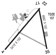
| Runways: | 04/22 17/35 |
| Longest Runway: | 04/22 is 5420 ft (1652 m) long |
| Runways with an Instrument Approach: | 22 |
KMMV Airport Runway Details
| Runway 04/22 | 5420 ft x 100 ft (1652 m x 30 m) | |
| Runway Length Source: | 3RD PARTY SURVEY as of 02/22/2018 | |
| Surface: | Asphalt - Excellent condition - No special surface treatment | |
| Runway Edge Lights: | High Intensity | |
Runway Weight Bearing Capacity (in thousands of pounds) |
||
| Single Wheel Landing Gear: | 40.0 | |
| Dual Wheel Landing Gear: | 50.0 | |
| Dual Tandem Wheel Landing Gear: | 80.0 | |
Runway 04 |
Runway 22 |
|
Elevation: |
160.6 | 160.7 |
Latitude: |
45-11-30.3272N | 45-11-59.3133N |
Longitude: |
123-08-53.4469W | 123-07-49.8311W |
|
Runway True Alignment: |
057 | 237 |
ILS Type: |
ILS | |
Glide Path Angle: |
3.0 degrees | 3.0 degrees |
Traffic Pattern: |
Left | Left |
Runway Markings Type: |
Nonprecision Instrument | Precision Instrument |
Runway Markings Condition: |
Good | Good |
Object at End: |
TREES | TREES |
Object Height: |
55 | 115 |
Distance from End: |
1620 | 2277 |
Object Centerline Offset: |
0 ft. left and right of centerline | 770 ft. left of centerline |
Visual Glide Slope Indicators: |
4-Light PAPI On Left Side Of Runway | 4-Light PAPI On Left Side Of Runway |
Approach Light System: |
1,400 Foot Medium Intensity Approach Lighting System With Runway Alignment Indicator Lights | |
REIL: |
Yes | |
Threshold Crossing Height: |
40 | 55 |
Declared Distances |
||
Take Off Run Avbl. (TORA): |
5420 | 5420 |
Take Off Distance Avbl. (TODA): |
5420 | 5420 |
Actual Stop Dist. Avbl. (ASDA): |
5320 | 5420 |
Landing Dist. Avbl. (LDA): |
5320 | 5420 |
| Runway 17/35 | 4340 ft x 75 ft (1323 m x 23 m) | |
| Runway Length Source: | 3RD PARTY SURVEY as of 02/22/2018 | |
| Surface: | Asphalt - Excellent condition - No special surface treatment | |
Runway Weight Bearing Capacity (in thousands of pounds) |
||
| Single Wheel Landing Gear: | 30.0 | |
Runway 17 |
Runway 35 |
|
Elevation: |
160.7 | 162.6 |
Latitude: |
45-11-56.1215N | 45-11-13.5067N |
Longitude: |
123-07-52.0037W | 123-07-58.2122W |
|
Runway True Alignment: |
186 | 006 |
Glide Path Angle: |
0.0 degrees | 0.0 degrees |
Traffic Pattern: |
Left | Left |
Runway Markings Type: |
Basic | Basic |
Runway Markings Condition: |
Poor | Poor |
Object at End: |
TREE | |
Object Height: |
85 | |
Distance from End: |
1808 | |
Object Centerline Offset: |
0 ft. left and right of centerline | 770 ft. left of centerline |
Services
Airframe Repair: |
Major |
Powerplant Repair: |
Major |
Bulk Oxygen: |
None |
Fuel Available: |
100LL |
Landing Fees: |
No |
Parking: |
Tiedowns available |
Maps & Diagrams
KMMV Sectional
Flight Planning
at skyvector.com
at skyvector.com