Location
Latitude: |
32-42-03.7000N (32.701028) |
Longitude: |
080-00-11.7000W (-80.00325) |
Elevation: |
18.6 feet MSL (6 m MSL) |
Magnetic Variation: |
8.2 W (as of April 2024 from WMM2020 model) |
Time Zone: |
UTC -5.0 (Standard Time) UTC -4.0 (Daylight Savings Time) |
From City: |
06 N.M. SW of Charleston, South Carolina |
Found On: |
Charlotte Chart |
FAA Region: |
ASO |
Contacts
Manager: |
Publicly owned: |
| ELLIOTT SUMMEY 5500 INTERNATIONAL BLVD, #101 CHARLESTON, SC 29418 843-767-7000 |
CHARLESTON CO AVN AUTHORITY 5500 INTL BLVD, # 101 CHARLESTON, SC 29418-6911 843-767-7000 |
Operations
Airport Status: |
Operational |
Facility Use: |
Public |
Type: |
Airport |
Activation Date: |
04/1943 |
Control tower: |
No |
Attendance (Months/Days/Hours): |
Months/Days/Hours ALL/ALL/0600-2200 |
Boundary ARTCC: |
ZJX (Jacksonville) |
Responsible ARTCC: |
ZJX (Jacksonville) |
Lighting Schedule: |
SEE RMK |
Segmented Circle Indicator: |
Yes |
Traffic Pattern Altitude (MSL): |
1019 feet (311 m) |
NOTAMs Facility: |
AND |
NOTAM-D Service: |
Yes |
International Airport of Entry: |
No |
Customs Landing Rights: |
No |
Military Landing Rights: |
Yes |
Civil/Military Joint Use: |
No |
Based Aircraft
| Single Engine: | 29 |
| Jet Engine: | 2 |
Annual Operations (as of 02/23/2022)
| Total Operations: | 31000 | |
| Air Taxi: | 2022 | 6.5% |
| GA Local: | 10108 | 32.6% |
| GA Itinerant: | 15870 | 51.2% |
| Military Aircraft: | 3000 | 9.7% |
Communications
| CTAF: | 122.800 |
| Unicom: | 122.800 |
| Clearance Del.: | 119.85 119.85 119.85 119.85 119.85 |
| Approach: | CHARLESTON |
| Departure: | CHARLESTON |
| AWOS-3: | 123.775 (843-559-3123) |
Fixed Based Operators (FBOs) & Fuel
(Click on a business for detail)
Please help us keep this information up to date. This is a FREE SERVICE just like everything else on Airport Guide! If you see that a business needs to be added, modified, or deleted please fill out our Update Form.
To add, modify, or delete a business click here.
Please help us keep this information up to date. This is a FREE SERVICE just like everything else on Airport Guide! If you see that a business needs to be added, modified, or deleted please fill out our Update Form.
Area Code: 803 |
| Business Name | Frequency | Phone | Fuel Grade |
|---|---|---|---|
| Charleston Executive Aviation
Update FBO info |
Unicom 122.8 | 559-2401 | 100LL, Jet A |
Flight Service Stations
| Primary | Alternate | |
| FSS on Field: | N | |
| FSS Name (ID): | Anderson(AND) | |
| Frequency: | ||
| Toll Free Phone: | 1-800-WX-BRIEF |
Instrument Procedures / Charts
FAA Terminal Procedures valid from 0901Z 03/21/24 to 0901Z 04/18/24.
There are various types of charts available for an airport. They are listed in the Page Type column. Here is a legend for those types:
APD - Airport Diagram
DP - Departure Procedure Charts
HOT - Hot Spots
IAP - Instrument Approach Procedure Charts
MIN - Minimums
STAR - Standard Terminal Arrival Charts
| Page Type | Page Name | Volume | Action Since Last Cycle |
|---|---|---|---|
| DP | EXECUTIVE ONE (RNAV) | SE-2 | |
| DP | KIAWAH TWO (RNAV) | SE-2 | |
| DP | KMBEE TWO (RNAV) | SE-2 | |
| IAP | ILS OR LOC RWY 09 | SE-2 | |
| IAP | RNAV (GPS) RWY 04 | SE-2 | |
| IAP | RNAV (GPS) RWY 09 | SE-2 | |
| IAP | RNAV (GPS) RWY 27 | SE-2 | |
| MIN | ALTERNATE MINIMUMS | SE-2 | |
| MIN | TAKEOFF MINIMUMS | SE-2 | |
| STAR | AMYLU THREE (RNAV) | SE-2 | |
| STAR | AMYLU THREE (RNAV)[DELIMITER] CONT.1 | SE-2 | |
| STAR | BAGGY THREE (RNAV) | SE-2 | |
| STAR | BAGGY THREE (RNAV)[DELIMITER] CONT.1 | SE-2 | |
| STAR | OSPRI SEVEN (RNAV) | SE-2 | |
| STAR | OSPRI SEVEN (RNAV)[DELIMITER] CONT.1 | SE-2 |
Terminal Procedures are only available for airports in several countries with more being added all the time. If you are looking for a specific country's charts, please send an email to support(at)airportguide.com stating the country name. This will be used to prioritize the implementation.
Navigation Aids (Navaids) near KJZI
| Dist (NM) | ID | Morse Code | Name | Type | Freq | True Hdg | Mag Hdg |
|---|---|---|---|---|---|---|---|
| 11.7 | CHS | _ . _ . . . . . . . . | Charleston | VORTAC | 113.50 | 351 | 359 |
| 12.4 | CHS | _ . _ . . . . . . . . | Charleston | VOT | 111.00 | 351 | 359 |
| 17.2 | CH | _ . _ . . . . . | Ashly | NDB | 329 | 343 | 351 |
| 25.7 | DYB | _ . . _ . _ _ _ . . . | Dorchester County | NDB | 365 | 327 | 335 |
| 34.8 | RBW | . _ . _ . . . . _ _ | Walterboro | NDB | 221 | 292 | 300 |
| 38.5 | NBC | _ . _ . . . _ . _ . | Beaufort | TACAN | 110.50 | 249 | 257 |
| 50.3 | GGE | _ _ . _ _ . . | Georgetown | NDB | 242 | 42 | 50 |
| 51.0 | PHH | . _ _ . . . . . . . . . | Andrews | NDB | 255 | 27 | 35 |
| 51.5 | VAN | . . . _ . _ _ . | Vance | VORTAC | 110.40 | 334 | 342 |
| 54.2 | MNI | _ _ _ . . . | Manning | NDB | 381 | 349 | 357 |
| 61.5 | CKI | _ . _ . _ . _ . . | Kingstree | NDB | 404 | 6 | 14 |
| 62.5 | EDS | . _ . . . . . | Edisto | VOR-DME | 111.40 | 316 | 324 |
| 65.0 | SV | . . . . . . _ | Wassa | NDB | 335 | 230 | 238 |
| 66.2 | HEK | . . . . . _ . _ | Stuckey | NDB | 236 | 21 | 29 |
| 67.6 | ALD | . _ . _ . . _ . . | Allendale | VOR | 116.70 | 286 | 294 |
| 69.1 | SAV | . . . . _ . . . _ | Savannah | VORTAC | 115.95 | 241 | 249 |
| 69.8 | SAV | . . . . _ . . . _ | Savannah Travis Fld | VOT | 111.00 | 240 | 248 |
| 70.3 | CFY | _ . _ . . . _ . _ . _ _ | Evans | NDB | 420 | 9 | 17 |
| 71.0 | SVN | . . . . . . _ _ . | Hunter | VOR-DME | 111.60 | 234 | 242 |
| 75.5 | SA | . . . . _ | Mavis | NDB | 368 | 243 | 251 |
Nearby Airports with Fuel
Notices to Airmen (NOTAMS)
Remarks
| A110-2 | DEER & BIRDS ON & INVOF ARPT. |
| A110-3 | FOR CD CTC CHARLESTON APCH AT 843-414-2832. |
| A57-27 | APPROACH SLOPE TO DISPLACED THR. IS 50:1. |
| A81-APT | SR-SS, TO ACTVT AND INCR INTST REIL RWY 09 & 27; HIRL RWY 09/27; MIRL RWY 04/22 - CTAF. SR-SS, PAPI RWY 09 & 27 OPR CONSLY. SS-SR, REIL RWY 09 & 27; PAPI RWY 09 & 27; HIRL RWY 09/27 OPR CONSLY, TO INCR INTST - CTAF. SS-SR, TO ACTVT MIRL RWY 04/22 - CTAF. |
| A83 | SUPPLEMENTARY LGTD WINDCONES RWYS 04, 22, 09 & 27. |
| E111 | ARPT EXISTED PRIOR TO 1958 |
Runways
Runway Summary
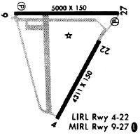
| Runways: | 04/22 09/27 |
| Longest Runway: | 09/27 is 5350 ft (1631 m) long |
| Runways with an Instrument Approach: | 09 |
KJZI Airport Runway Details
| Runway 04/22 | 4313 ft x 150 ft (1315 m x 46 m) | |
| Runway Length Source: | 3RD PARTY SURVEY as of 07/08/2009 | |
| Surface: | Concrete - Good condition - No special surface treatment | |
| Runway Edge Lights: | Medium Intensity | |
Runway Weight Bearing Capacity (in thousands of pounds) |
||
| Single Wheel Landing Gear: | 45.0 | |
| Dual Wheel Landing Gear: | 56.0 | |
Runway 04 |
Runway 22 |
|
Elevation: |
9.8 | 11.1 |
Latitude: |
32-41-28.0252N | 32-42-04.1342N |
Longitude: |
080-00-20.9895W | 079-59-54.0947W |
|
Runway True Alignment: |
032 | 212 |
Glide Path Angle: |
0.0 degrees | 0.0 degrees |
Traffic Pattern: |
Left | Left |
Runway Markings Type: |
Nonprecision Instrument | Basic |
Runway Markings Condition: |
Good | Good |
Object at End: |
TREE | |
Object Height: |
8 | |
Distance from End: |
310 | |
Object Centerline Offset: |
149 ft. right of centerline |
| Runway 09/27 | 5350 ft x 100 ft (1631 m x 30 m) | |
| Runway Length Source: | 3RD PARTY SURVEY as of 07/08/2009 | |
| Surface: | Concrete - Good condition - Saw-cut or plastic grooved | |
| Runway Edge Lights: | High Intensity | |
Runway Weight Bearing Capacity (in thousands of pounds) |
||
| Single Wheel Landing Gear: | 60.0 | |
| Dual Wheel Landing Gear: | 100.0 | |
Runway 09 |
Runway 27 |
|
Elevation: |
18.6 | 11.1 |
Latitude: |
32-42-17.4787N | 32-42-18.1738N |
Longitude: |
080-00-46.4272W | 079-59-43.8230W |
|
Runway True Alignment: |
089 | 269 |
ILS Type: |
ILS/DME | |
Glide Path Angle: |
3.0 degrees | 3.0 degrees |
Traffic Pattern: |
Left | Left |
Runway Markings Type: |
Precision Instrument | Nonprecision Instrument |
Runway Markings Condition: |
Good | Good |
Object at End: |
TREE | BRUSH |
Object Height: |
112 | 16 |
Distance from End: |
4162 | 438 |
Object Centerline Offset: |
149 ft. right of centerline | |
Visual Glide Slope Indicators: |
4-Light PAPI On Left Side Of Runway | 4-Light PAPI On Right Side Of Runway |
REIL: |
Yes | Yes |
Threshold Crossing Height: |
50 | 44 |
Threshold Elevation: |
11.7 | |
Displaced Threshold: |
350 | |
Threshold Latitude: |
32-42-18.1300N | |
Threshold Longitude: |
079-59-47.9185W |
Services
Airframe Repair: |
None |
Powerplant Repair: |
None |
Bottled Oxygen: |
None |
Bulk Oxygen: |
None |
Fuel Available: |
100LL |
Landing Fees: |
No |
Parking: |
Tiedowns available |
Maps & Diagrams
KJZI Sectional
Flight Planning
at skyvector.com
at skyvector.com