Location
Latitude: |
36-51-25.1000N (36.856972) |
Longitude: |
087-27-18.3000W (-87.455083) |
Elevation: |
563.5 feet MSL (172 m MSL) |
Magnetic Variation: |
3.7 W (as of April 2024 from WMM2020 model) |
Time Zone: |
UTC -6.0 (Standard Time) UTC -5.0 (Daylight Savings Time) |
From City: |
02 N.M. E of Hopkinsville, Kentucky |
Found On: |
St Louis Chart |
FAA Region: |
ASO |
Contacts
Manager: |
Publicly owned: |
| WILLIAM OUTLAW 300 MEMORIAL FIELD DRIVE HOPKINSVILLE, KY 42240 270-887-4157 |
CITY OF HOPKINSVILLE 300 MEMORIAL FIELD DRIVE HOPKINSVILLE, KY 42240 270-887-4157 |
Operations
Airport Status: |
Operational |
Facility Use: |
Public |
Type: |
Airport |
Activation Date: |
11/1952 |
Control tower: |
No |
Attendance (Months/Days/Hours): |
Months/Days/Hours ALL/ALL/0900-1700 |
Boundary ARTCC: |
ZME (Memphis) |
Responsible ARTCC: |
ZME (Memphis) |
Lighting Schedule: |
SEE RMK |
Segmented Circle Indicator: |
Yes |
Traffic Pattern Altitude (MSL): |
1564 feet (477 m) |
NOTAMs Facility: |
LOU |
NOTAM-D Service: |
Yes |
International Airport of Entry: |
No |
Customs Landing Rights: |
No |
Military Landing Rights: |
Yes |
Civil/Military Joint Use: |
No |
Based Aircraft
| Single Engine: | 36 |
| Multi Engine: | 1 |
| Gliders: | 1 |
Annual Operations (as of 11/05/2019)
| Total Operations: | 41000 | |
| Air Taxi: | 3000 | 7.3% |
| GA Local: | 18700 | 45.6% |
| GA Itinerant: | 13300 | 32.4% |
| Military Aircraft: | 6000 | 14.6% |
Communications
| CTAF: | 122.800 |
| Unicom: | 122.800 |
| Approach: | CAMPBELL 118.1 118.1 118.1 |
| Departure: | CAMPBELL 118.1 118.1 118.1 |
| AWOS-3: | 132.575 (270-886-6311) |
Fixed Based Operators (FBOs) & Fuel
(Click on a business for detail)
Please help us keep this information up to date. This is a FREE SERVICE just like everything else on Airport Guide! If you see that a business needs to be added, modified, or deleted please fill out our Update Form.
To add, modify, or delete a business click here.
Please help us keep this information up to date. This is a FREE SERVICE just like everything else on Airport Guide! If you see that a business needs to be added, modified, or deleted please fill out our Update Form.
Area Code: 270 |
| Business Name | Frequency | Phone | Fuel Grade |
|---|---|---|---|
| Aviation Services
Update FBO info |
Unicom 122.8 | 886-8638 | 100LL, Jet A |
| Hopkinsville-Christian County Airport
Update FBO info |
Unicom 122.8 | 887-4157 | 100LL, Mogas, Jet A |
Flight Service Stations
| Primary | Alternate | |
| FSS on Field: | N | |
| FSS Name (ID): | Louisville(LOU) | |
| Frequency: | ||
| Toll Free Phone: | 1-800-WX-BRIEF |
Instrument Procedures / Charts
FAA Terminal Procedures valid from 0901Z 03/21/24 to 0901Z 04/18/24.
There are various types of charts available for an airport. They are listed in the Page Type column. Here is a legend for those types:
APD - Airport Diagram
DP - Departure Procedure Charts
HOT - Hot Spots
IAP - Instrument Approach Procedure Charts
MIN - Minimums
STAR - Standard Terminal Arrival Charts
| Page Type | Page Name | Volume | Action Since Last Cycle |
|---|---|---|---|
| IAP | RNAV (GPS) RWY 08 | SE-1 | |
| IAP | RNAV (GPS) RWY 26 | SE-1 | |
| MIN | TAKEOFF MINIMUMS | SE-1 |
Terminal Procedures are only available for airports in several countries with more being added all the time. If you are looking for a specific country's charts, please send an email to support(at)airportguide.com stating the country name. This will be used to prioritize the implementation.
Navigation Aids (Navaids) near KHVC
| Dist (NM) | ID | Morse Code | Name | Type | Freq | True Hdg | Mag Hdg |
|---|---|---|---|---|---|---|---|
| 5.8 | HIX | . . . . . . _ . . _ | Honey Grove | NDB | 356 | 75 | 79 |
| 7.5 | FK | . . _ . _ . _ | Airbe | NDB | 273 | 164 | 168 |
| 12.2 | HXW | . . . . _ . . _ . _ _ | Screaming Eagle | TACAN | 114.90 | 192 | 196 |
| 14.2 | CKV | _ . _ . _ . _ . . . _ | Clarksville | VOR-DME | 110.60 | 171 | 175 |
| 20.1 | CK | _ . _ . _ . _ | Snuff | NDB | 335 | 170 | 174 |
| 26.3 | GMH | _ _ . _ _ . . . . | Muhlenberg | NDB | 362 | 32 | 36 |
| 32.8 | CCT | _ . _ . _ . _ . _ | Central City | DME | 109.8 | 16 | 20 |
| 32.9 | ON | _ _ _ _ . | Music | NDB | 279 | 136 | 140 |
| 40.9 | EU | . . . _ | Murey | NDB | 368 | 258 | 261 |
| 43.8 | DMZ | _ . . _ _ _ _ . . | Dickson | NDB | 203 | 178 | 182 |
| 46.5 | AEY | . _ . _ . _ _ | Waverly | NDB | 329 | 197 | 201 |
| 46.7 | BW | _ . . . . _ _ | Noora | NDB | 236 | 88 | 92 |
| 48.7 | BWG | _ . . . . _ _ _ _ . | Bowling Green | DME | 117.9 | 84 | 88 |
| 48.8 | OW | _ _ _ . _ _ | Higuy | NDB | 341 | 16 | 20 |
| 55.0 | OWB | _ _ _ . _ _ _ . . . | Owensboro | VOR-DME | 108.60 | 14 | 18 |
| 55.1 | VI | . . . _ . . | Opery | NDB | 344 | 135 | 139 |
| 57.0 | BNA | _ . . . _ . . _ | Nashville | VORTAC | 114.10 | 139 | 143 |
| 58.8 | BNA | _ . . . _ . . _ | Nashville Metropoln | VOT | 108.60 | 139 | 143 |
| 58.9 | TIQ | _ . . _ _ . _ | Trainer | NDB | 410 | 232 | 235 |
| 60.8 | BDD | _ . . . _ . . _ . . | Bellgrade | NDB | 254 | 286 | 289 |
Nearby Airports with Fuel
Notices to Airmen (NOTAMS)
Remarks
| A110-2 | FOR CD CTC CAMPBELL APCH AT 270-798-6441. |
| A13 | 270-498-3566 |
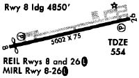
| A81-APT | ACTVT REIL RWY 08 & 26; PAPI RWY 08 & 26; MIRL RWY 08/26 - CTAF |
| E111 | EXISTED PRIOR TO 1959. |
Runways
Runway Summary
| Runways: | 08/26 |
| Longest Runway: | 08/26 is 5505 ft (1678 m) long |
| Runways with an Instrument Approach: | 26 |
KHVC Airport Runway Details
| Runway 08/26 | 5505 ft x 100 ft (1678 m x 30 m) | |
| Runway Length Source: | 3RD PARTY SURVEY as of 10/25/2012 | |
| Surface: | Asphalt - Good condition - No special surface treatment | |
| Runway Edge Lights: | Medium Intensity | |
Runway Weight Bearing Capacity (in thousands of pounds) |
||
| Single Wheel Landing Gear: | 14.0 | |
Runway 08 |
Runway 26 |
|
Elevation: |
536.7 | 563.5 |
Latitude: |
36-51-19.3277N | 36-51-30.8434N |
Longitude: |
087-27-51.3864W | 087-26-45.1818W |
|
Runway True Alignment: |
078 | 258 |
ILS Type: |
LOCALIZER | |
Glide Path Angle: |
3.5 degrees | 4.0 degrees |
Traffic Pattern: |
Left | Left |
Runway Markings Type: |
Nonprecision Instrument | Nonprecision Instrument |
Runway Markings Condition: |
Good | Good |
Object at End: |
TREES | TREES |
Object Height: |
87 | 61 |
Distance from End: |
863 | 1682 |
Object Centerline Offset: |
344 ft. left of centerline | 393 ft. left of centerline |
Visual Glide Slope Indicators: |
4-Light PAPI On Left Side Of Runway | 4-Light PAPI On Left Side Of Runway |
REIL: |
Yes | Yes |
Threshold Crossing Height: |
38 | 34 |
Services
Fuel Available: |
100LL |
Landing Fees: |
No |
Parking: |
Tiedowns available |
Maps & Diagrams
KHVC Sectional
Flight Planning
at skyvector.com
at skyvector.com