Location
Latitude: |
35-27-37.9990N (35.460555) |
Longitude: |
077-57-53.7390W (-77.964928) |
Elevation: |
133.6 feet MSL (41 m MSL) |
Magnetic Variation: |
9.7 W (as of April 2024 from WMM2020 model) |
Time Zone: |
UTC -5.0 (Standard Time) UTC -4.0 (Daylight Savings Time) |
From City: |
03 N.M. N of Goldsboro, North Carolina |
Found On: |
Charlotte Chart |
FAA Region: |
ASO |
Contacts
Manager: |
Publicly owned: |
| MARK LOVEDAY 240 AVIATION ROAD PIKEVILLE, NC 27863 919-734-7630 |
WAYNE COUNTY 240 AVIATION ROAD PIKEVILLE, NC 27863 919-734-7630 |
Operations
Airport Status: |
Operational |
Facility Use: |
Public |
Type: |
Airport |
Activation Date: |
11/1967 |
Control tower: |
No |
Attendance (Months/Days/Hours): |
Months/Days/Hours ALL/MON-SAT/0800-1700 |
Boundary ARTCC: |
ZDC (Washington) |
Responsible ARTCC: |
ZDC (Washington) |
Lighting Schedule: |
SEE RMK |
Segmented Circle Indicator: |
Yes |
Traffic Pattern Altitude (MSL): |
1134 feet (346 m) |
NOTAMs Facility: |
GWW |
NOTAM-D Service: |
Yes |
International Airport of Entry: |
No |
Customs Landing Rights: |
No |
Military Landing Rights: |
Yes |
Civil/Military Joint Use: |
No |
Based Aircraft
| Single Engine: | 39 |
| Multi Engine: | 5 |
| GA Helicopters: | 4 |
Annual Operations (as of 05/12/2023)
| Total Operations: | 16200 | |
| Air Taxi: | 2000 | 12.3% |
| GA Local: | 6500 | 40.1% |
| GA Itinerant: | 6700 | 41.4% |
| Military Aircraft: | 1000 | 6.2% |
Communications
| CTAF: | 122.975 |
| Unicom: | 122.975 |
| Approach: | SEYMOUR JOHNSON 121.175 121.175 WASHINGTON ARTCC |
| Departure: | SEYMOUR JOHNSON 121.175 121.175 WASHINGTON ARTCC |
| AWOS-3P: | 118.975 (919-731-4473) |
- APCH/DEP SVC PRVDD BY WASHINGTON ARTCC (ZDC) ON 123.85/279.65 (NEW BERN RCAG) WHEN APCH CTL CLSD.
Fixed Based Operators (FBOs) & Fuel
(Click on a business for detail)
Please help us keep this information up to date. This is a FREE SERVICE just like everything else on Airport Guide! If you see that a business needs to be added, modified, or deleted please fill out our Update Form.
To add, modify, or delete a business click here.
Please help us keep this information up to date. This is a FREE SERVICE just like everything else on Airport Guide! If you see that a business needs to be added, modified, or deleted please fill out our Update Form.
Area Code: 919 |
| Business Name | Frequency | Phone | Fuel Grade |
|---|---|---|---|
| Spitfire Aviation
Update FBO info |
Unicom 122.7 | 734-7630 | 100LL, Jet A |
Flight Service Stations
| Primary | Alternate | |
| FSS on Field: | N | |
| FSS Name (ID): | Raleigh(RDU) | |
| Frequency: | ||
| Toll Free Phone: | 1-800-WX-BRIEF |
Instrument Procedures / Charts
FAA Terminal Procedures valid from 0901Z 03/21/24 to 0901Z 04/18/24.
There are various types of charts available for an airport. They are listed in the Page Type column. Here is a legend for those types:
APD - Airport Diagram
DP - Departure Procedure Charts
HOT - Hot Spots
IAP - Instrument Approach Procedure Charts
MIN - Minimums
STAR - Standard Terminal Arrival Charts
| Page Type | Page Name | Volume | Action Since Last Cycle |
|---|---|---|---|
| IAP | ILS OR LOC RWY 23 | SE-2 | |
| IAP | RNAV (GPS) RWY 05 | SE-2 | |
| IAP | RNAV (GPS) RWY 23 | SE-2 | |
| IAP | RNAV (GPS)-A | SE-2 | |
| MIN | ALTERNATE MINIMUMS | SE-2 | |
| MIN | TAKEOFF MINIMUMS | SE-2 |
Terminal Procedures are only available for airports in several countries with more being added all the time. If you are looking for a specific country's charts, please send an email to support(at)airportguide.com stating the country name. This will be used to prioritize the implementation.
Navigation Aids (Navaids) near KGWW
| Dist (NM) | ID | Morse Code | Name | Type | Freq | True Hdg | Mag Hdg |
|---|---|---|---|---|---|---|---|
| 7.5 | GSB | _ _ . . . . _ . . . | Seymour Johnson | TACAN | 116.50 | 182 | 192 |
| 18.4 | IS | . . . . . | Stals | NDB | 276 | 134 | 144 |
| 20.6 | ISO | . . . . . _ _ _ | Kinston | VORTAC | 117.50 | 105 | 115 |
| 22.5 | JN | . _ _ _ _ . | Jurly | NDB | 263 | 272 | 282 |
| 23.4 | DKA | _ . . _ . _ . _ | Kenan | NDB | 332 | 174 | 184 |
| 30.4 | PGV | . _ _ . _ _ . . . . _ | Belvoir | FAN MARKER | 69 | 79 | |
| 32.5 | AQE | . _ _ _ . _ . | Alwood | NDB | 230 | 62 | 72 |
| 33.5 | TYI | _ _ . _ _ . . | Tar River | VORTAC | 117.80 | 22 | 32 |
| 34.7 | HQT | . . . . _ _ . _ _ | Harnett | NDB | 417 | 267 | 277 |
| 35.0 | CTZ | _ . _ . _ _ _ . . | Clinton | NDB | 412 | 213 | 223 |
| 35.1 | ETC | . _ _ . _ . | Tarboro | NDB | 257 | 35 | 45 |
| 42.0 | RNW | . _ . _ . . _ _ | Chocowinity | NDB | 388 | 85 | 95 |
| 44.5 | OA | _ _ _ . _ | Ellas | NDB | 261 | 163 | 173 |
| 45.2 | MCZ | _ _ _ . _ . _ _ . . | Williamston | NDB | 336 | 57 | 67 |
| 45.8 | FGP | . . _ . _ _ . . _ _ . | Fort Bragg | NDB | 393 | 245 | 254 |
| 46.3 | LE | . _ . . . | Leevy | NDB | 350 | 307 | 317 |
| 46.9 | RDU | . _ . _ . . . . _ | Raleigh/Durham | VORTAC | 117.20 | 302 | 312 |
| 50.4 | POB | . _ _ . _ _ _ _ . . . | Pope | NDB | 338 | 254 | 263 |
| 50.7 | EWN | . . _ _ _ . | New Bern | VOR-DME | 113.60 | 117 | 127 |
| 50.8 | EW | . . _ _ | Katfi | NDB | 362 | 121 | 131 |
Nearby Airports with Fuel
Notices to Airmen (NOTAMS)
Remarks
| A110-2 | ULTRALIGHT; GLIDER & PARACHUTE ACTIVITY PPR CALL 919-734-7630. |
| A110-3 | HELICOPTER OPS ON TWY LEADING TO T HANGERS. HELIPAD ON TWY WITH TRAFFIC CONES AND FLAGS. |
| A110-4 | BIRD ACTIVITY INVOF ARPT. |
| A110-5 | FOR EMERG SVC AFT HRS CALL 919-734-7630. |
| A110-6 | FOR CD CTC SEYMOUR JOHNSON APCH AT 919-722-4186. WHEN APCH CLSD, FOR CD CTC WASHINGTON ARTCC AT 703-771-3587. |
| A17 | UNATNDD FEDERAL HOL. |
| A43-23 | RWY 23 PAPI NOT COINCIDENTAL WITH ILS RWY 23 GP. |
| A58-05 | HAS 9 FT BRUSH 135 FT FM THR OFFSET 327 LEFT OF CNTRLN. |
| A70-FUEL-10 | 0LL 24 HR SS FUEL AVAILABLE W CC. |
| A81-APT | ACTVT REIL RWY 05 & 23; ODALS RWY 23; MIRL RWY 05/23 - CTAF. PAPIS RWY 05 & 23 OPERS CONS. |
Runways
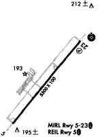
Runway Summary
| Runways: | 05/23 |
| Longest Runway: | 05/23 is 5501 ft (1677 m) long |
| Runways with an Instrument Approach: | 23 |
KGWW Airport Runway Details
| Runway 05/23 | 5501 ft x 100 ft (1677 m x 30 m) | |
| Runway Length Source: | 3RD PARTY SURVEY as of 08/16/2018 | |
| Surface: | Asphalt - Excellent condition - No special surface treatment | |
| Runway Pavement Class: | 19 /F/C/X/T | |
| Runway Edge Lights: | Medium Intensity | |
Runway Weight Bearing Capacity (in thousands of pounds) |
||
| Single Wheel Landing Gear: | 51.0 | |
| Dual Wheel Landing Gear: | 71.0 | |
Runway 05 |
Runway 23 |
|
Elevation: |
132.7 | 132.7 |
Latitude: |
35-27-16.7824N | 35-27-59.2154N |
Longitude: |
077-58-14.5482W | 077-57-32.9264W |
|
Runway True Alignment: |
039 | 219 |
ILS Type: |
ILS | |
Glide Path Angle: |
3.0 degrees | 3.0 degrees |
Traffic Pattern: |
Left | Left |
Runway Markings Type: |
Nonprecision Instrument | Precision Instrument |
Runway Markings Condition: |
Good | Good |
Object at End: |
TREES | TREES |
Object Height: |
93 | 52 |
Distance from End: |
2163 | 782 |
Object Centerline Offset: |
393 ft. right of centerline | 581 ft. right of centerline |
Visual Glide Slope Indicators: |
4-Light PAPI On Left Side Of Runway | 4-Light PAPI On Left Side Of Runway |
Approach Light System: |
Omnidirectional Approach Lighting System | |
REIL: |
Yes | Yes |
Threshold Crossing Height: |
40 | 44 |
Services
Fuel Available: |
100LL, Jet A-1+ |
Parking: |
Tiedowns available |
Maps & Diagrams
KGWW Sectional
Flight Planning
at skyvector.com
at skyvector.com