Location
Latitude: |
41-12-00.7700N (41.200214) |
Longitude: |
074-37-22.9270W (-74.623035) |
Elevation: |
421.6 feet MSL (129 m MSL) |
Magnetic Variation: |
12.4 W (as of April 2024 from WMM2020 model) |
Time Zone: |
UTC -5.0 (Standard Time) UTC -4.0 (Daylight Savings Time) |
From City: |
01 N.M. SW of Sussex, New Jersey |
Found On: |
New York Chart |
FAA Region: |
AEA |
Contacts
Manager: |
Privately owned: |
| JOHN MASSARI PO BOX 311 SUSSEX, NJ 07461 (973) 702-1640 |
SUSSEX AVIATION LLC PO BOX 311 SUSSEX, NJ 07461 (973) 702-1640 |
Operations
Airport Status: |
Operational |
Facility Use: |
Public |
Type: |
Airport |
Activation Date: |
05/1945 |
Control tower: |
No |
Attendance (Months/Days/Hours): |
Months/Days/Hours ALL/ALL/0830-1700 |
Boundary ARTCC: |
ZNY (New York) |
Responsible ARTCC: |
ZNY (New York) |
Lighting Schedule: |
SEE RMK |
Segmented Circle Indicator: |
No |
Traffic Pattern Altitude (MSL): |
1422 feet (433 m) |
NOTAMs Facility: |
MIV |
NOTAM-D Service: |
Yes |
International Airport of Entry: |
No |
Customs Landing Rights: |
No |
Military Landing Rights: |
No |
Civil/Military Joint Use: |
No |
Based Aircraft
| Single Engine: | 22 |
| Multi Engine: | 3 |
Annual Operations (as of 05/01/2019)
| Total Operations: | 21444 | |
| GA Local: | 13922 | 64.9% |
| GA Itinerant: | 7522 | 35.1% |
Communications
| CTAF: | 122.700 |
| Unicom: | 122.700 |
| Approach: | NEW YORK 127.6 127.6 |
| Departure: | NEW YORK 127.6 127.6 |
| ASOS: | 118.525 (973-875-0859) |
Fixed Based Operators (FBOs) & Fuel
(Click on a business for detail)
Please help us keep this information up to date. This is a FREE SERVICE just like everything else on Airport Guide! If you see that a business needs to be added, modified, or deleted please fill out our Update Form.
To add, modify, or delete a business click here.
Please help us keep this information up to date. This is a FREE SERVICE just like everything else on Airport Guide! If you see that a business needs to be added, modified, or deleted please fill out our Update Form.
Area Code: 973 |
| Business Name | Frequency | Phone | Fuel Grade |
|---|---|---|---|
| Aerobatex
Update FBO info |
875-7337, 850-1819 | 100LL, Jet A | |
| Sussex Airport, Inc.
Update FBO info |
Unicom 122.7 | 875-7337, -0783 | 100LL, Jet A |
Flight Service Stations
| Primary | Alternate | |
| FSS on Field: | N | |
| FSS Name (ID): | Millville(MIV) | |
| Frequency: | ||
| Toll Free Phone: | 1-800-WX-BRIEF |
Instrument Procedures / Charts
FAA Terminal Procedures valid from 0901Z 03/21/24 to 0901Z 04/18/24.
There are various types of charts available for an airport. They are listed in the Page Type column. Here is a legend for those types:
APD - Airport Diagram
DP - Departure Procedure Charts
HOT - Hot Spots
IAP - Instrument Approach Procedure Charts
MIN - Minimums
STAR - Standard Terminal Arrival Charts
| Page Type | Page Name | Volume | Action Since Last Cycle |
|---|---|---|---|
| IAP | RNAV (GPS) RWY 03 | NE-2 | Changed |
| IAP | VOR-A | NE-2 | Changed |
| MIN | ALTERNATE MINIMUMS | NE-2 | |
| MIN | TAKEOFF MINIMUMS | NE-2 |
Terminal Procedures are only available for airports in several countries with more being added all the time. If you are looking for a specific country's charts, please send an email to support(at)airportguide.com stating the country name. This will be used to prioritize the implementation.
Navigation Aids (Navaids) near KFWN
| Dist (NM) | ID | Morse Code | Name | Type | Freq | True Hdg | Mag Hdg |
|---|---|---|---|---|---|---|---|
| 8.8 | SAX | . . . . _ _ . . _ | Sparta | VORTAC | 115.70 | 154 | 166 |
| 12.6 | HUO | . . . . . . _ _ _ _ | Huguenot | VOR-DME | 116.10 | 6 | 18 |
| 16.6 | STW | . . . _ . _ _ | Stillwater | VOR-DME | 109.60 | 222 | 234 |
| 24.7 | SW | . . . . _ _ | Neely | NDB | 335 | 45 | 58 |
| 25.7 | BWZ | _ . . . . _ _ _ _ . . | Broadway | VOR-DME | 114.20 | 200 | 212 |
| 28.9 | CAT | _ . _ . . _ _ | Chatham | NDB | 254 | 162 | 174 |
| 32.5 | TE | _ . | Torby | NDB | 214 | 136 | 149 |
| 32.6 | SKU | . . . _ . _ . . _ | Stanwyck | FAN MARKER | 52 | 65 | |
| 32.6 | SKU | . . . _ . _ . . _ | Stanwyck | NDB | 261 | 52 | 65 |
| 33.0 | TEB | _ . _ . . . | Teterboro | VOR-DME | 108.40 | 129 | 142 |
| 35.6 | MS | _ _ . . . | Monga | NDB | 359 | 342 | 354 |
| 35.8 | EWR | . . _ _ . _ . | Maryann | FAN MARKER | 146 | 158 | |
| 37.2 | PO | . _ _ . _ _ _ | Meier | NDB | 403 | 52 | 65 |
| 37.4 | SBJ | . . . _ . . . . _ _ _ | Solberg | VOR-DME | 112.90 | 188 | 200 |
| 37.5 | EWR | . . _ _ . _ . | Newark | DME | 113.75 | 147 | 159 |
| 42.1 | LHY | . _ . . . . . . _ . _ _ | Lake Henry | VORTAC | 110.80 | 293 | 305 |
| 42.3 | LGA | . _ . . _ _ . . _ | La Guardia | VOR-DME | 113.10 | 125 | 138 |
| 45.6 | IGN | . . _ _ . _ . | Kingston | VOR-DME | 117.60 | 51 | 64 |
| 47.2 | FJC | . . _ . . _ _ _ _ . _ . | Allentown | VORTAC | 117.50 | 233 | 245 |
| 47.2 | CMK | _ . _ . _ _ _ . _ | Carmel | VOR-DME | 116.60 | 83 | 96 |
Nearby Airports with Fuel
Notices to Airmen (NOTAMS)
Remarks
| A110-1 | PAJA, DROP ZONE LCTD SW SIDE OF RWY. |
| A110-10 | NO TGL OR PLA ALLOWED. |
| A110-3 | NON-STD TWY WIDTH, TWY AND RWY MRKGS. AIRCRAFT OPNS ON BLACKTOP ONLY. |
| A110-6 | MAIN TWY SW 1500 FT CLSD. |
| A110-8 | FOR CD CTC NEW YORK APCH AT 800-645-3206. |
| A110-9 | DEER AND BIRDS ON AND INVOF ARPT. |
| A43-03 | RWY 03 PAPI OTS INDEFLY. |
| A48-03 | RWY 03 REIL OTS INDEFLY. |
| A48-21 | RWY 21 REIL OTS INDEFLY. |
| A57-03 | RWY 03 APCH RATIO 14:1 TO DSPLCD THR. |
| A57-21 | RWY 21 APCH RATIO 16:1 TO DSPLCD THR. |
| A58-03 | 15 FT TREE, 38 FT FM RWY END, 176 FT RIGHT. |
| A58-21 | 10 FT SIGN, 41 FT FM RWY END, 44 FT RIGHT. |
| A70-FUEL-A | SELF-SVC. |
| A81-APT | DUSK-DAWN. ACTVT MIRL RWY 03/21 - CTAF. |
| E111 | BUILT PRIOR TO 1959. |
Runways
Runway Summary
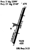
| Runways: | 03/21 |
| Longest Runway: | 03/21 is 3506 ft (1069 m) long |
| Runways with an Instrument Approach: |
KFWN Airport Runway Details
| Runway 03/21 | 3506 ft x 75 ft (1069 m x 23 m) | |
| Runway Length Source: | 3RD PARTY SURVEY as of 12/30/2017 | |
| Surface: | Asphalt - Fair condition - No special surface treatment | |
| Runway Edge Lights: | Medium Intensity | |
Runway 03 |
Runway 21 |
|
Elevation: |
421.1 | 401.0 |
Latitude: |
41-11-44.1037N | 41-12-17.4370N |
Longitude: |
074-37-29.1674W | 074-37-16.6853W |
|
Runway True Alignment: |
016 | 196 |
Glide Path Angle: |
4.0 degrees | 0.0 degrees |
Traffic Pattern: |
Left | Left |
Runway Markings Type: |
Basic | Basic |
Runway Markings Condition: |
Fair | Fair |
Object at End: |
TREES | TREES |
Object Height: |
50 | 69 |
Distance from End: |
250 | 375 |
Object Centerline Offset: |
260 ft. right of centerline | 79 ft. right of centerline |
Visual Glide Slope Indicators: |
2-Light PAPI On Left Side Of Runway | |
REIL: |
Yes | Yes |
Threshold Crossing Height: |
40 | |
Threshold Elevation: |
419.6 | 401.4 |
Displaced Threshold: |
466 | 756 |
Threshold Latitude: |
41-11-48.5334N | 41-12-10.2583N |
Threshold Longitude: |
074-37-27.5164W | 074-37-19.3767W |
Services
Airframe Repair: |
Minor |
Powerplant Repair: |
Minor |
Bottled Oxygen: |
None |
Bulk Oxygen: |
None |
Fuel Available: |
100LL, Jet A |
Landing Fees: |
Yes |
Parking: |
Hangars and tiedowns available |
Maps & Diagrams
KFWN Sectional
Flight Planning
at skyvector.com
at skyvector.com