Location
Latitude: |
40-30-37.1744N (40.510326) |
Longitude: |
101-37-12.5257W (-101.620146) |
Elevation: |
3276.0 feet MSL (999 m MSL) |
Magnetic Variation: |
5.8 E (as of April 2024 from WMM2020 model) |
Time Zone: |
UTC -7.0 (Standard Time) UTC -6.0 (Daylight Savings Time) |
From City: |
01 N.M. SE of Imperial, Nebraska |
Found On: |
Cheyenne Chart |
FAA Region: |
ACE |
Contacts
Manager: |
Publicly owned: |
| KEN SCHILKE P.O. BOX 637 IMPERIAL, NE 69033-0637 308-883-1593 |
IMPERIAL AIRPORT AUTHORITY P.O. BOX 637, BOX 637 IMPERIAL, NE 69033-0637 308-882-5643 |
Operations
Airport Status: |
Operational |
Facility Use: |
Public |
Type: |
Airport |
Activation Date: |
01/1943 |
Control tower: |
No |
Attendance (Months/Days/Hours): |
Months/Days/Hours ALL/MON-FRI/0800-1700 |
Boundary ARTCC: |
ZDV (Denver) |
Responsible ARTCC: |
ZDV (Denver) |
Lighting Schedule: |
SEE RMK |
Segmented Circle Indicator: |
Yes |
Traffic Pattern Altitude (MSL): |
4276 feet (1303 m) |
NOTAMs Facility: |
IML |
NOTAM-D Service: |
Yes |
International Airport of Entry: |
No |
Customs Landing Rights: |
No |
Military Landing Rights: |
Yes |
Civil/Military Joint Use: |
No |
Based Aircraft
| Single Engine: | 15 |
| Multi Engine: | 2 |
Annual Operations (as of 05/25/2021)
| Total Operations: | 9700 | |
| Air Taxi: | 1000 | 10.3% |
| GA Local: | 7500 | 77.3% |
| GA Itinerant: | 1200 | 12.4% |
Communications
| CTAF: | 122.800 |
| Unicom: | 122.800 |
| ASOS: | 124.175 (308-882-5186) |
- APCH/DEP CTL SVC PRVDD BY DENVER ARTCC (ZDV) ON FREQS 132.7/397.85 (OGALLALA RCAG).
Fixed Based Operators (FBOs) & Fuel
(Click on a business for detail)
Please help us keep this information up to date. This is a FREE SERVICE just like everything else on Airport Guide! If you see that a business needs to be added, modified, or deleted please fill out our Update Form.
To add, modify, or delete a business click here.
Please help us keep this information up to date. This is a FREE SERVICE just like everything else on Airport Guide! If you see that a business needs to be added, modified, or deleted please fill out our Update Form.
Area Code: 308 |
| Business Name | Frequency | Phone | Fuel Grade |
|---|
Flight Service Stations
| Primary | Alternate | |
| FSS on Field: | N | |
| FSS Name (ID): | Columbus(OLU) | |
| Frequency: | ||
| Toll Free Phone: | 1-800-WX-BRIEF |
Instrument Procedures / Charts
FAA Terminal Procedures valid from 0901Z 03/21/24 to 0901Z 04/18/24.
There are various types of charts available for an airport. They are listed in the Page Type column. Here is a legend for those types:
APD - Airport Diagram
DP - Departure Procedure Charts
HOT - Hot Spots
IAP - Instrument Approach Procedure Charts
MIN - Minimums
STAR - Standard Terminal Arrival Charts
| Page Type | Page Name | Volume | Action Since Last Cycle |
|---|---|---|---|
| IAP | RNAV (GPS) RWY 13 | NC-2 | |
| IAP | RNAV (GPS) RWY 31 | NC-2 | |
| MIN | ALTERNATE MINIMUMS | NC-2 | |
| MIN | TAKEOFF MINIMUMS | NC-2 |
Terminal Procedures are only available for airports in several countries with more being added all the time. If you are looking for a specific country's charts, please send an email to support(at)airportguide.com stating the country name. This will be used to prioritize the implementation.
Navigation Aids (Navaids) near IML
| Dist (NM) | ID | Morse Code | Name | Type | Freq | True Hdg | Mag Hdg |
|---|---|---|---|---|---|---|---|
| 22.2 | GGF | _ _ . _ _ . . . _ . | Grant | NDB | 359 | 346 | 340 |
| 32.0 | HCT | . . . . _ . _ . _ | Hayes Center | VORTAC | 117.70 | 95 | 89 |
| 37.2 | SAE | . . . . _ . | Searle | VOR-DME | 110.20 | 349 | 343 |
| 47.4 | SYF | . . . _ . _ _ . . _ . | St Francis | NDB | 386 | 188 | 182 |
| 50.4 | MCK | _ _ _ . _ . _ . _ | Mc Cook | VOR-DME | 115.30 | 111 | 106 |
| 51.1 | CNP | _ . _ . _ . . _ _ . | Chappell | NDB | 383 | 312 | 306 |
| 51.2 | LBF | . _ . . _ . . . . . _ . | North Platte | VOR-DME | 117.40 | 50 | 44 |
| 53.0 | MCK | _ _ _ . _ . _ . _ | Mc Cook | FAN MARKER | 111 | 106 | |
| 58.2 | LB | . _ . . _ . . . | Panbe | NDB | 416 | 54 | 49 |
| 62.9 | OKS | _ _ _ _ . _ . . . | Oshkosh | NDB | 233 | 328 | 322 |
| 64.3 | OIN | _ _ _ . . _ . | Oberlin | NDB | 341 | 129 | 124 |
| 65.5 | JDM | . _ _ _ _ . . _ _ | Wheatfield | NDB | 408 | 156 | 150 |
| 67.4 | GLD | _ _ . . _ . . _ . . | Goodland | VORTAC | 115.10 | 182 | 176 |
| 67.9 | CSB | _ . _ . . . . _ . . . | Harry Strunk | NDB | 389 | 100 | 95 |
| 71.2 | SNY | . . . _ . _ . _ _ | Sidney | VOR-DME | 115.90 | 300 | 294 |
| 73.0 | GL | _ _ . . _ . . | Shugr | NDB | 414 | 179 | 173 |
| 73.4 | BAJ | _ . . . . _ . _ _ _ | Batten | NDB | 392 | 271 | 265 |
| 73.7 | DWL | _ . . . _ _ . _ . . | Willow | NDB | 353 | 72 | 67 |
| 74.4 | AKO | . _ _ . _ _ _ _ | Akron | VOR-DME | 114.40 | 253 | 247 |
| 76.6 | OZB | _ _ _ _ _ . . _ . . . | Cozad | VOR | 109.00 | 73 | 68 |
Nearby Airports with Fuel
Notices to Airmen (NOTAMS)
Remarks
| A110-1 | BIRDS INVOF ARPT - SEASONAL. |
| A110-2 | EXTENSIVE CROP SPRAYING OPNS INVOF ARPT APR THRU AUG. |
| A110-3 | RY 03/21 NOT PLOWED WINTER MONTHS. |
| A110-4 | FOR CD CTC DENVER ARTCC AT 303-651-4257. |
| A70-FUEL-10 | 0LL 100LL SELF SVC AVBL 24 HRS WITH CREDIT CARD. |
| A81-APT | ACTVT MIRL RY 13/31 PAPI RY 13 & 31 AND REIL RY 13 & 31 - CTAF. |
| A84 | 4 FT X 8 FT CONCRETE MARKER SEGMENTS. |
| E111 | EXISTED PRIOR TO 1959. |
Runways
Runway Summary
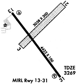
| Runways: | 03/21 13/31 |
| Longest Runway: | 13/31 is 5022 ft (1531 m) long |
| Runways with an Instrument Approach: |
IML Airport Runway Details
| Runway 03/21 | 2756 ft x 280 ft (840 m x 85 m) | |
| Runway Length Source: | FAA as of 10/24/2007 | |
| Surface: | Turf - Fair condition - No special surface treatment | |
Runway 03 |
Runway 21 |
|
Elevation: |
3267.2 | 3274.3 |
Latitude: |
40-30-34.4300N | 40-30-53.4700N |
Longitude: |
101-37-22.8600W | 101-36-57.3500W |
|
Runway True Alignment: |
046 | 226 |
Glide Path Angle: |
0.0 degrees | 0.0 degrees |
Traffic Pattern: |
Left | Left |
Runway Markings Type: |
None | None |
Object at End: |
POLE | TREES |
Object Height: |
36 | 20 |
Distance from End: |
1252 | 476 |
Object Centerline Offset: |
230 ft. right of centerline | 53 ft. left of centerline |
| Runway 13/31 | 5022 ft x 100 ft (1531 m x 30 m) | |
| Runway Length Source: | 3RD PARTY SURVEY as of 05/29/2006 | |
| Surface: | Turf - Fair condition - No special surface treatment | |
| Runway Edge Lights: | Medium Intensity | |
Runway Weight Bearing Capacity (in thousands of pounds) |
||
| Single Wheel Landing Gear: | 21.0 | |
Runway 13 |
Runway 31 |
|
Elevation: |
3272.6 | 3264.6 |
Latitude: |
40-30-53.4362N | 40-30-13.4759N |
Longitude: |
101-37-33.1222W | 101-36-54.5862W |
|
Runway True Alignment: |
144 | 324 |
Glide Path Angle: |
3.0 degrees | 3.0 degrees |
Traffic Pattern: |
Left | Left |
Runway Markings Type: |
Nonprecision Instrument | Nonprecision Instrument |
Runway Markings Condition: |
Good | Good |
Object at End: |
ROAD | RR |
Object Height: |
20 | 27 |
Distance from End: |
750 | 900 |
Object Centerline Offset: |
230 ft. right of centerline | 53 ft. left of centerline |
Visual Glide Slope Indicators: |
2-Light PAPI On Left Side Of Runway | 2-Light PAPI On Left Side Of Runway |
REIL: |
Yes | Yes |
Threshold Crossing Height: |
40 | 40 |
Services
Airframe Repair: |
None |
Powerplant Repair: |
None |
Fuel Available: |
100LL |
Landing Fees: |
No |
Parking: |
Tiedowns available |
Maps & Diagrams
IML Sectional
Flight Planning
at skyvector.com
at skyvector.com