Location
Latitude: |
38-55-47.2000N (38.929778) |
Longitude: |
081-49-10.1000W (-81.819472) |
Elevation: |
758.2 feet MSL (231 m MSL) |
Magnetic Variation: |
7.9 W (as of April 2024 from WMM2020 model) |
Time Zone: |
UTC -5.0 (Standard Time) UTC -4.0 (Daylight Savings Time) |
From City: |
06 N.M. SW of Ravenswood, West Virginia |
Found On: |
Cincinnati Chart |
FAA Region: |
AEA |
Contacts
Manager: |
Publicly owned: |
| RALPH DENNIS 912 AIRPORT RD MILLWOOD, WV 25262 304-273-8114 |
JACKSON COUNTY CMSN P. O. BOX 800 RIPLEY, WV 25271 304-373-2220 |
Operations
Airport Status: |
Operational |
Facility Use: |
Public |
Type: |
Airport |
Control tower: |
No |
Attendance (Months/Days/Hours): |
Months/Days/Hours ALL/ALL/0800-1600 |
Boundary ARTCC: |
ZID (Indianapolis) |
Responsible ARTCC: |
ZID (Indianapolis) |
Lighting Schedule: |
SEE RMK |
Segmented Circle Indicator: |
Yes |
Traffic Pattern Altitude (MSL): |
1758 feet (536 m) |
NOTAMs Facility: |
EKN |
NOTAM-D Service: |
Yes |
Military Landing Rights: |
Yes |
Based Aircraft
| Single Engine: | 24 |
| Multi Engine: | 1 |
| GA Helicopters: | 1 |
Annual Operations (as of 07/06/2022)
| Total Operations: | 12402 | |
| Air Taxi: | 102 | 0.8% |
| GA Local: | 6000 | 48.4% |
| GA Itinerant: | 6000 | 48.4% |
| Military Aircraft: | 300 | 2.4% |
Communications
| CTAF: | 122.800 |
| Unicom: | 122.800 |
| Approach: | HUNTINGTON 128.4 128.4 |
| Departure: | HUNTINGTON 128.4 128.4 |
| AWOS-2: | 121.3 (304-273-3424) |
Fixed Based Operators (FBOs) & Fuel
(Click on a business for detail)
Please help us keep this information up to date. This is a FREE SERVICE just like everything else on Airport Guide! If you see that a business needs to be added, modified, or deleted please fill out our Update Form.
To add, modify, or delete a business click here.
Please help us keep this information up to date. This is a FREE SERVICE just like everything else on Airport Guide! If you see that a business needs to be added, modified, or deleted please fill out our Update Form.
Area Code: 304 |
| Business Name | Frequency | Phone | Fuel Grade |
|---|
Flight Service Stations
| Primary | Alternate | |
| FSS on Field: | N | |
| FSS Name (ID): | Elkins(EKN) | |
| Frequency: | ||
| Toll Free Phone: | 1-800-WX-BRIEF |
Instrument Procedures / Charts
FAA Terminal Procedures valid from 0901Z 03/21/24 to 0901Z 04/18/24.
There are various types of charts available for an airport. They are listed in the Page Type column. Here is a legend for those types:
APD - Airport Diagram
DP - Departure Procedure Charts
HOT - Hot Spots
IAP - Instrument Approach Procedure Charts
MIN - Minimums
STAR - Standard Terminal Arrival Charts
| Page Type | Page Name | Volume | Action Since Last Cycle |
|---|---|---|---|
| IAP | RNAV (GPS) RWY 04 | NE-4 | |
| IAP | RNAV (GPS) RWY 22 | NE-4 | |
| MIN | TAKEOFF MINIMUMS | NE-4 |
Terminal Procedures are only available for airports in several countries with more being added all the time. If you are looking for a specific country's charts, please send an email to support(at)airportguide.com stating the country name. This will be used to prioritize the implementation.
Navigation Aids (Navaids) near I18
| Dist (NM) | ID | Morse Code | Name | Type | Freq | True Hdg | Mag Hdg |
|---|---|---|---|---|---|---|---|
| 14.3 | HNN | . . . . _ . _ . | Henderson | DME | 115.9 | 222 | 230 |
| 24.3 | UGS | . . _ _ _ . . . . | University | NDB | 250 | 324 | 332 |
| 24.9 | PK | . _ _ . _ . _ | Versi | NDB | 388 | 38 | 46 |
| 25.0 | UNI | . . _ _ . . . | Athens | FAN MARKER | 315 | 323 | |
| 33.2 | PKB | . _ _ . _ . _ _ . . . | Marietta Ohio | FAN MARKER | 34 | 42 | |
| 34.9 | HVQ | . . . . . . . _ _ _ . _ | Charleston | VOR-DME | 117.40 | 176 | 184 |
| 35.0 | CRW | _ . _ . . _ . . _ _ | Charleston | VOT | 108.80 | 162 | 170 |
| 37.0 | JPU | . _ _ _ . _ _ . . . _ | Parkersburg | VOR-DME | 114.45 | 33 | 41 |
| 53.7 | EOP | . _ _ _ . _ _ . | Waverly | NDB | 385 | 285 | 293 |
| 56.8 | YRK | _ . _ _ . _ . _ . _ | York | VORTAC | 112.80 | 252 | 260 |
| 58.8 | HRA | . . . . . _ . . _ | Zanesville | NDB | 204 | 355 | 363 |
| 60.8 | ZZV | _ _ . . _ _ . . . . . _ | Zanesville | VOR-DME | 114.95 | 356 | 364 |
| 64.0 | RZT | . _ . _ _ . . _ | Ross County | NDB | 236 | 298 | 306 |
| 64.7 | XUB | _ . . _ . . _ _ . . . | Yellow Bud | VOR | 112.50 | 304 | 312 |
| 69.0 | GTC | _ _ . _ _ . _ . | Guyandot | NDB | 293 | 183 | 191 |
| 69.0 | ECB | . _ . _ . _ . . . | Newcombe | DME | 110.4 | 228 | 235 |
| 70.4 | PZO | . _ _ . _ _ . . _ _ _ | Peebles | NDB | 329 | 270 | 277 |
| 72.2 | HEH | . . . . . . . . . | Newark | NDB | 524 | 335 | 343 |
| 73.7 | LCK | . _ . . _ . _ . _ . _ | Rickenbacker | TACAN | 69X | 316 | 324 |
| 74.0 | LC | . _ . . _ . _ . | Pickl | NDB | 376 | 320 | 328 |
Nearby Airports with Fuel
Notices to Airmen (NOTAMS)
Remarks
| A110-2 | DEER AND BIRDS ON & INVOF ARPT. |
| A110-3 | +482 FT STACK 1/2 MILE NW OF ARPT. |
| A110-4 | RWY SAFETY AREA HAS SFC VARIATIONS. |
| A110-5 | RWY 04/22, 50 FT DROP-OFF 200 FT FM THR - EACH END. |
| A110-6 | 15 FT TREES PARALLEL TO RWY 04, 75 FT L OF CNTRLN. |
| A110-7 | FOR CD CTC HUNTINGTON ATCT AT 304-453-2490. |
| A16 | 304-532-6781 MGR CELL. |
| A43-22 | VGSI AND DESCENT ANGLES NOT COINCIDENT. |
| A58-22 | 16 FT TREES, 150-200 DSTC, 170-250 FT L. |
| A81-APT | ACTVT REIL RWY 04 & 22, PAPI RWY 04 & 22; MIRL RWY 04/22 & WINDSOCK LGT - CTAF. |
Runways
Runway Summary
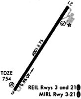
| Runways: | 04/22 |
| Longest Runway: | 04/22 is 4000 ft (1219 m) long |
| Runways with an Instrument Approach: |
I18 Airport Runway Details
| Runway 04/22 | 4000 ft x 75 ft (1219 m x 23 m) | |
| Runway Length Source: | 3RD PARTY SURVEY as of 02/02/2011 | |
| Surface: | Asphalt - Excellent condition - No special surface treatment | |
| Runway Edge Lights: | Medium Intensity | |
Runway Weight Bearing Capacity (in thousands of pounds) |
||
| Single Wheel Landing Gear: | 12.5 | |
Runway 04 |
Runway 22 |
|
Elevation: |
738.0 | 758.2 |
Latitude: |
38-55-29.9704N | 38-56-04.3519N |
Longitude: |
081-49-22.6281W | 081-48-57.6420W |
|
Runway True Alignment: |
030 | 210 |
Glide Path Angle: |
3.0 degrees | 4.0 degrees |
Runway Markings Type: |
Nonprecision Instrument | Nonprecision Instrument |
Runway Markings Condition: |
Good | Good |
Object at End: |
TREES | TREES |
Object Height: |
61 | 22 |
Distance from End: |
1430 | 220 |
Object Centerline Offset: |
0 ft. left and right of centerline | 245 ft. left of centerline |
Visual Glide Slope Indicators: |
2-Light PAPI On Left Side Of Runway | 2-Light PAPI On Left Side Of Runway |
REIL: |
Yes | Yes |
Threshold Crossing Height: |
50 | 50 |
Services
Airframe Repair: |
Major |
Powerplant Repair: |
Major |
Bottled Oxygen: |
None |
Bulk Oxygen: |
None |
Fuel Available: |
100LL |
Landing Fees: |
No |
Parking: |
Hangars and tiedowns available |
Maps & Diagrams
I18 Sectional
Flight Planning
at skyvector.com
at skyvector.com