Location
Latitude: |
37-48-40.5220N (37.811256) |
Longitude: |
088-33-00.9347W (-88.550259) |
Elevation: |
398.0 feet MSL (121 m MSL) |
Magnetic Variation: |
3.1 W (as of April 2024 from WMM2020 model) |
Time Zone: |
UTC -6.0 (Standard Time) UTC -5.0 (Daylight Savings Time) |
From City: |
04 N.M. N of Harrisburg, Illinois |
Found On: |
St Louis Chart |
FAA Region: |
AGL |
Contacts
Manager: |
Publicly owned: |
| DALE SHELTON P.O. BOX 33 HARRISBURG, IL 62946 618-253-7806 |
HARRISBURG RALEIGH AIRPORT P.O. BOX 33 HARRISBURG, IL 62946 618-253-7806 |
Operations
Airport Status: |
Operational |
Facility Use: |
Public |
Type: |
Airport |
Activation Date: |
09/1950 |
Control tower: |
No |
Attendance (Months/Days/Hours): |
Months/Days/Hours ALL/ALL/0800-1700 |
Boundary ARTCC: |
ZKC (Kansas City) |
Responsible ARTCC: |
ZKC (Kansas City) |
Lighting Schedule: |
SEE RMK |
Segmented Circle Indicator: |
Yes |
Traffic Pattern Altitude (MSL): |
1398 feet (426 m) |
NOTAMs Facility: |
HSB |
NOTAM-D Service: |
Yes |
International Airport of Entry: |
No |
Customs Landing Rights: |
No |
Military Landing Rights: |
Yes |
Civil/Military Joint Use: |
No |
Based Aircraft
| Single Engine: | 13 |
| Multi Engine: | 1 |
| GA Helicopters: | 1 |
Annual Operations (as of 03/31/2018)
| Total Operations: | 18000 | |
| Air Taxi: | 1500 | 8.3% |
| GA Local: | 10400 | 57.8% |
| GA Itinerant: | 5800 | 32.2% |
| Military Aircraft: | 300 | 1.7% |
Communications
| CTAF: | 122.800 |
| Unicom: | 122.800 |
| AWOS-3PT: | 135.925 (618-253-3010) |
- APCH/DEP SVC PRVDD BY KANSAS CITY ARTCC ON FREQS 127.475/346.275 (MARION RCAG).
Fixed Based Operators (FBOs) & Fuel
(Click on a business for detail)
Please help us keep this information up to date. This is a FREE SERVICE just like everything else on Airport Guide! If you see that a business needs to be added, modified, or deleted please fill out our Update Form.
To add, modify, or delete a business click here.
Please help us keep this information up to date. This is a FREE SERVICE just like everything else on Airport Guide! If you see that a business needs to be added, modified, or deleted please fill out our Update Form.
Area Code: 618 |
| Business Name | Frequency | Phone | Fuel Grade |
|---|---|---|---|
| Harrisburg-Raleigh Airport
Update FBO info |
Unicom 122.8 | 253-7806 | 100LL, Jet A |
Flight Service Stations
| Primary | Alternate | |
| FSS on Field: | N | |
| FSS Name (ID): | Saint Louis(STL) | |
| Frequency: | ||
| Toll Free Phone: | 1-800-WX-BRIEF |
Instrument Procedures / Charts
FAA Terminal Procedures valid from 0901Z 03/21/24 to 0901Z 04/18/24.
There are various types of charts available for an airport. They are listed in the Page Type column. Here is a legend for those types:
APD - Airport Diagram
DP - Departure Procedure Charts
HOT - Hot Spots
IAP - Instrument Approach Procedure Charts
MIN - Minimums
STAR - Standard Terminal Arrival Charts
| Page Type | Page Name | Volume | Action Since Last Cycle |
|---|---|---|---|
| IAP | RNAV (GPS) RWY 06 | EC-3 | |
| IAP | RNAV (GPS) RWY 24 | EC-3 | |
| MIN | ALTERNATE MINIMUMS | EC-3 | |
| MIN | TAKEOFF MINIMUMS | EC-3 |
Terminal Procedures are only available for airports in several countries with more being added all the time. If you are looking for a specific country's charts, please send an email to support(at)airportguide.com stating the country name. This will be used to prioritize the implementation.
Navigation Aids (Navaids) near HSB
| Dist (NM) | ID | Morse Code | Name | Type | Freq | True Hdg | Mag Hdg |
|---|---|---|---|---|---|---|---|
| 0.2 | HSB | . . . . . . . _ . . . | Harrisburg-Raleigh | NDB | 230 | 84 | 87 |
| 20.0 | MW | _ _ . _ _ | Jonny | NDB | 382 | 274 | 277 |
| 22.2 | MWA | _ _ . _ _ . _ | Marion | DME | 110.4 | 261 | 264 |
| 33.1 | MD | _ _ _ . . | Cabbi | NDB | 388 | 276 | 279 |
| 34.8 | FWC | . . _ . . _ _ _ . _ . | Wayne County | NDB | 257 | 10 | 13 |
| 35.2 | VNN | . . . _ _ . _ . | Mount Vernon | DME | 113.8 | 339 | 342 |
| 38.0 | PXV | . _ _ . _ . . _ . . . _ | Pocket City | VORTAC | 113.30 | 79 | 82 |
| 40.4 | BDD | _ . . . _ . . _ . . | Bellgrade | NDB | 254 | 188 | 191 |
| 46.0 | SAM | . . . . _ _ _ | Samsville | DME | 116.6 | 28 | 31 |
| 46.5 | ENL | . _ . . _ . . | Centralia | VORTAC | 115.00 | 321 | 324 |
| 50.1 | CNG | _ . _ . _ . _ _ . | Cunningham | VOR-DME | 113.10 | 195 | 198 |
| 50.2 | PDW | . _ _ . _ . . . _ _ | Evansville | NDB | 284 | 73 | 76 |
| 53.7 | SLO | . . . . _ . . _ _ _ | Salem | NDB | 400 | 338 | 341 |
| 55.3 | CIR | _ . _ . . . . _ . | Cairo | NDB | 397 | 215 | 218 |
| 57.3 | OLY | _ _ _ . _ . . _ . _ _ | Olney | NDB | 272 | 17 | 20 |
| 59.9 | CGI | _ . _ . _ _ . . . | Cape Girardeau | DME | 112.9 | 234 | 237 |
| 64.2 | CG | _ . _ . _ _ . | Dutch | NDB | 248 | 238 | 241 |
| 65.8 | OWB | _ _ _ . _ _ _ . . . | Owensboro | VOR-DME | 108.60 | 93 | 97 |
| 66.4 | CCT | _ . _ . _ . _ . _ | Central City | DME | 109.8 | 112 | 116 |
| 66.6 | EU | . . . _ | Murey | NDB | 368 | 169 | 172 |
Nearby Airports with Fuel
Notices to Airmen (NOTAMS)
Remarks
| A110-1 | ULTRALIGHT ACTIVITY ON & INVOF ARPT. |
| A110-2 | FOR SVCS OR JET A FUEL AFT HRS CALL AMGR AT 618-499-5058 (CELL). |
| A110-3 | 24 HR SELF SERVE 100LL FUEL AVBL WITH CREDIT CARD. |
| A110-4 | FOR CD CTC KANSAS CITY ARTCC AT 913-254-8508. |
| A15 | EMAIL ADDRESS: DSHELTON1018@GMAIL.COM (ALL LOWER CASE) |
| A31-14/32 | HAS A 900 FT STWY NW END. |
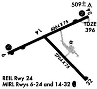
| A81-APT | REIL RWY 06 & 24; MIRL RWY 06/24 PRESET ON LOW INTST; TO INCR INTST & ACTVT MIRL RWY 14/32 - CTAF. |
Runways
Runway Summary
| Runways: | 06/24 14/32 |
| Longest Runway: | 06/24 is 5013 ft (1528 m) long |
| Runways with an Instrument Approach: |
HSB Airport Runway Details
| Runway 06/24 | 5013 ft x 75 ft (1528 m x 23 m) | |
| Runway Length Source: | STATE as of 11/30/2005 | |
| Surface: | Asphalt - Fair condition - No special surface treatment | |
| Runway Edge Lights: | Medium Intensity | |
Runway Weight Bearing Capacity (in thousands of pounds) |
||
| Single Wheel Landing Gear: | 12.0 | |
Runway 06 |
Runway 24 |
|
Elevation: |
386.7 | 396.2 |
Latitude: |
37-48-32.2651N | 37-48-54.6989N |
Longitude: |
088-33-34.0917W | 088-32-38.3814W |
|
Runway True Alignment: |
063 | 243 |
Glide Path Angle: |
3.0 degrees | 3.0 degrees |
Traffic Pattern: |
Left | Left |
Runway Markings Type: |
Nonprecision Instrument | Nonprecision Instrument |
Runway Markings Condition: |
Good | Good |
Object at End: |
TREE | |
Object Height: |
31 | |
Distance from End: |
721 | |
Object Centerline Offset: |
179 ft. left of centerline | |
Visual Glide Slope Indicators: |
4-Light PAPI On Left Side Of Runway | 4-Light PAPI On Left Side Of Runway |
REIL: |
Yes | Yes |
Touchdown Lights: |
No | No |
Centerline Lights: |
No | No |
Threshold Crossing Height: |
35 | 35 |
| Runway 14/32 | 2764 ft x 75 ft (842 m x 23 m) | |
| Surface: | Asphalt - Fair condition - No special surface treatment | |
| Runway Edge Lights: | Medium Intensity | |
Runway Weight Bearing Capacity (in thousands of pounds) |
||
| Single Wheel Landing Gear: | 26.0 | |
Runway 14 |
Runway 32 |
|
Elevation: |
387.4 | 381.9 |
Latitude: |
37-48-45.7550N | 37-48-24.5520N |
Longitude: |
088-33-02.1790W | 088-32-40.4590W |
|
Runway True Alignment: |
141 | 321 |
Glide Path Angle: |
0.0 degrees | 0.0 degrees |
Traffic Pattern: |
Left | Left |
Runway Markings Type: |
Basic | Basic |
Runway Markings Condition: |
Fair | Fair |
Object Centerline Offset: |
179 ft. left of centerline | |
REIL: |
No | No |
Touchdown Lights: |
No | No |
Centerline Lights: |
No | No |
Services
Airframe Repair: |
Minor |
Powerplant Repair: |
Minor |
Bottled Oxygen: |
None |
Bulk Oxygen: |
None |
Fuel Available: |
100LL, Jet A |
Landing Fees: |
No |
Parking: |
Hangars and tiedowns available |
Maps & Diagrams
HSB Sectional
Flight Planning
at skyvector.com
at skyvector.com