
Location
Latitude: |
57-39-46.0794N (57.6628) |
Longitude: |
012-16-47.2815E (12.2798) |
Elevation: |
506 feet MSL (154 m MSL) |
Magnetic Variation: |
5.1 E (as of April 2024 from WMM2020 model) |
Time Zone: |
UTC +1.0 (Standard Time) UTC +2.0 (Daylight Savings Time) |
Contacts
Manager: |
: |
Operations
Airport Status: |
Operational |
Facility Use: |
Public |
Type: |
Airport |
Traffic Pattern Altitude (MSL): |
1506 feet (459 m) |
Based Aircraft
Annual Operations (as of )
Communications
| TWR: | 118.6 |
| TWR: | 123.5 |
| GND: | 121.9 |
| GOTEBORG APP: | 124.68 |
| ATIS: | 118.375 |
Fixed Based Operators (FBOs) & Fuel
(Click on a business for detail)
Please help us keep this information up to date. This is a FREE SERVICE just like everything else on Airport Guide! If you see that a business needs to be added, modified, or deleted please fill out our Update Form.
To add, modify, or delete a business click here.
Please help us keep this information up to date. This is a FREE SERVICE just like everything else on Airport Guide! If you see that a business needs to be added, modified, or deleted please fill out our Update Form.
| Business Name | Frequency | Phone | Fuel Grade |
|---|
Flight Service Stations
| Primary | Alternate | |
| FSS on Field: | ||
| FSS Name (ID): | ||
| Frequency: | ||
| Toll Free Phone: |
Instrument Procedures / Charts
Terminal Procedures are only available for airports in several countries with more being added all the time. If you are looking for a specific country's charts, please send an email to support(at)airportguide.com stating the country name. This will be used to prioritize the implementation.
Navigation Aids (Navaids) near GOT
| Dist (NM) | ID | Morse Code | Name | Type | Freq | True Hdg | Mag Hdg |
|---|---|---|---|---|---|---|---|
| 0.5 | LAV | Landvetter | VOR-DME | 114.60 | 141 | 136 | |
| 11.7 | BAK | Backa | VOR-DME | 112.70 | 236 | 231 | |
| 16.1 | NOL | Nolvik | VOR | 113.20 | 294 | 289 | |
| 16.4 | HAR | Harry | VOR | 117.50 | 53 | 48 | |
| 57.5 | JON | Jonkoping | VOR-DME | 115.80 | 83 | 78 | |
| 81.1 | AAL | Aalborg | VOR-DME | 116.70 | 246 | 241 | |
| 81.2 | AAL | Aalborg | TACAN | 116.70 | 246 | 241 | |
| 82.9 | KBG | Karlsborg | NDB | 312 | 52 | 47 | |
| 89.7 | JX | Vaxjo | NDB | 349 | 115 | 110 | |
| 90.1 | SVD | Sveda | VOR-DME | 116.20 | 173 | 168 | |
| 91.0 | GL | Aalborg | NDB | 398 | 248 | 243 | |
| 92.1 | VX | Vaxjo | NDB | 329 | 120 | 115 | |
| 95.9 | VEY | Vedby | VOR | 116.90 | 160 | 155 | |
| 96.0 | TU | Aarhus | NDB | 374 | 211 | 206 | |
| 99.5 | LJU | Ljungbyhed | VOR-DME | 113.40 | 161 | 156 |
Nearby Airports with Fuel
| Dist (NM) | Name (Airport IDs) | True Hdg | Mag Hdg | Fuel Grade |
|---|
Notices to Airmen (NOTAMS)
Remarks
No remarks for this landing facility
Runways
Runway Summary
| Runways: | 03/21 |
| Longest Runway: | 03/21 is 10823 ft (3299 m) long |
| Runways with an Instrument Approach: |
GOT Airport Runway Details
| Runway 03/21 | 10823 ft x 148 ft (3299 m x 45 m) | |
| Runway Edge Lights: | Yes Intensity | |
Runway 03 |
Runway 21 |
|
Elevation: |
478 | 506 |
Latitude: |
57.64950180053 | 57.67610168457 |
Longitude: |
12.267700195312 | 12.291899681091 |
|
Runway True Alignment: |
26 | 206 |
Glide Path Angle: |
0.0 degrees | 0.0 degrees |
REIL: |
Yes | Yes |
Threshold Elevation: |
478 | 506 |
Services
Maps & Diagrams
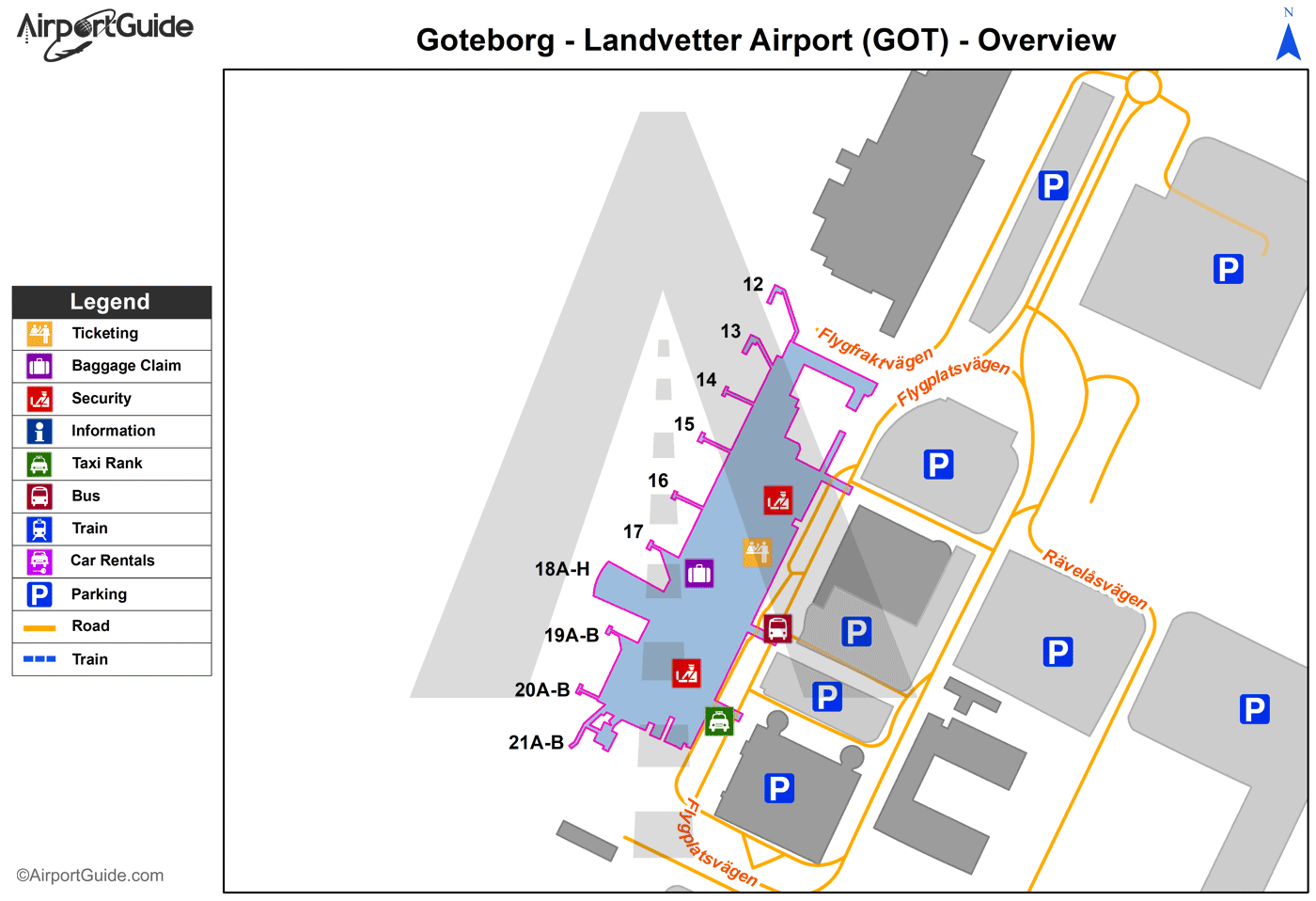
GOT Sectional
Flight Planning
at skyvector.com
at skyvector.com
