Location
Latitude: |
47-37-08.5000N (47.619028) |
Longitude: |
117-32-06.8000W (-117.535222) |
Elevation: |
2385.0 feet MSL (727 m MSL) |
Magnetic Variation: |
14.1 E (as of April 2024 from WMM2020 model) |
Time Zone: |
UTC -8.0 (Standard Time) UTC -7.0 (Daylight Savings Time) |
From City: |
05 N.M. SW of Spokane, Washington |
Found On: |
Seattle Chart |
FAA Region: |
ANM |
Contacts
Manager: |
Publicly owned: |
| LAWRENCE J KRAUTER 9000 W AIRPORT DR., SUITE 204 SPOKANE, WA 99224 (509) 455-6418 |
SPOKANE COUNTY-CITY ARPT BOARD, 9000 W AIRPORT DRIVE SPOKANE, WA 99224 509-455-6455 |
Operations
Airport Status: |
Operational |
Facility Use: |
Public |
Type: |
Airport |
Activation Date: |
08/1943 |
Control tower: |
Yes |
Attendance (Months/Days/Hours): |
Months/Days/Hours ALL/ALL/ALL |
Boundary ARTCC: |
ZSE (Seattle) |
Responsible ARTCC: |
ZSE (Seattle) |
Segmented Circle Indicator: |
No |
Traffic Pattern Altitude (MSL): |
3385 feet (1032 m) |
NOTAMs Facility: |
GEG |
NOTAM-D Service: |
Yes |
International Airport of Entry: |
No |
Customs Landing Rights: |
Yes |
Military Landing Rights: |
Yes |
Civil/Military Joint Use: |
No |
Aircraft Rescue and Firefighting: |
Class I ARFF Index: C Air Carrier Service: Scheduled Certification Date: 05/1973 |
Based Aircraft
| Single Engine: | 36 |
| Multi Engine: | 10 |
| Jet Engine: | 12 |
| GA Helicopters: | 2 |
Annual Operations (as of 01/01/2019)
| Total Operations: | 68256 | |
| Commercial: | 46134 | 67.6% |
| Air Taxi: | 7423 | 10.9% |
| GA Local: | 4489 | 6.6% |
| GA Itinerant: | 7906 | 11.6% |
| Military Aircraft: | 2304 | 3.4% |
Communications
| Unicom: | 122.950 |
| Tower: | SPOKANE 118.3 278.3 Hrs: 24 |
| Clearance Del.: | 127.55 |
| Ground: | 121.9 348.6 |
| Approach: | SPOKANE 123.75 ;205-025 133.35 ;026-204 263.0 ;026-204 282.25 ;205-025 Hrs: 24 372.9 |
| Departure: | SPOKANE 123.75 ;205-025 133.35 ;026-204 263.0 ;026-204 282.25 ;205-025 Hrs: 24 372.9 |
| ATIS: | 124.325 254.375 Hrs: 24 |
| ASOS: | (509-742-2544) |
| CLASS C: | 133.35 ;026-204 |
| CLASS C: | 282.25 ;205-025 |
| EMERG: | 121.5 |
| HILIE STAR: | 133.35 |
| ZOOMR STAR: | 282.25 |
| EMERG: | 243.0 |
| CLASS C: | 123.75 ;205-025 |
| ZOOMR STAR: | 123.75 |
| CLASS C: | 263.0 ;026-204 |
| HILIE STAR: | 263.0 |
Fixed Based Operators (FBOs) & Fuel
(Click on a business for detail)
Please help us keep this information up to date. This is a FREE SERVICE just like everything else on Airport Guide! If you see that a business needs to be added, modified, or deleted please fill out our Update Form.
To add, modify, or delete a business click here.
Please help us keep this information up to date. This is a FREE SERVICE just like everything else on Airport Guide! If you see that a business needs to be added, modified, or deleted please fill out our Update Form.
Area Code: 509 |
| Business Name | Frequency | Phone | Fuel Grade |
|---|---|---|---|
| Signature Flight Support
Update FBO info |
Unicom: 122.95, Arinc: 122.775 | +1 509 455 5204 | |
| Spokane Airways, Inc.
Update FBO info |
Unicom 122.95 | 747-2017 | 100LL, Jet A |
Flight Service Stations
| Primary | Alternate | |
| FSS on Field: | N | |
| FSS Name (ID): | Seattle(SEA) | |
| Frequency: | ||
| Toll Free Phone: | 1-800-WX-BRIEF |
Instrument Procedures / Charts
FAA Terminal Procedures valid from 0901Z 03/21/24 to 0901Z 04/18/24.
There are various types of charts available for an airport. They are listed in the Page Type column. Here is a legend for those types:
APD - Airport Diagram
DP - Departure Procedure Charts
HOT - Hot Spots
IAP - Instrument Approach Procedure Charts
MIN - Minimums
STAR - Standard Terminal Arrival Charts
| Page Type | Page Name | Volume | Action Since Last Cycle |
|---|---|---|---|
| APD | AIRPORT DIAGRAM | NW-1 | |
| DP | SPOKANE SEVEN | NW-1 | |
| DP | SPOKANE SEVEN[DELIMITER] CONT.1 | NW-1 | |
| IAP | ILS OR LOC RWY 03 | NW-1 | |
| IAP | ILS OR LOC RWY 21 | NW-1 | |
| IAP | ILS RWY 03 (CAT II - III) | NW-1 | |
| IAP | ILS RWY 03 (SA CAT I) | NW-1 | |
| IAP | ILS RWY 21 (CAT II - III) | NW-1 | |
| IAP | ILS RWY 21 (SA CAT I) | NW-1 | |
| IAP | RIDDLE HILL VISUAL RWY 08 | NW-1 | |
| IAP | RNAV (GPS) Y RWY 03 | NW-1 | |
| IAP | RNAV (GPS) Y RWY 08 | NW-1 | |
| IAP | RNAV (GPS) Y RWY 21 | NW-1 | |
| IAP | RNAV (GPS) Y RWY 26 | NW-1 | |
| IAP | RNAV (RNP) Z RWY 03 | NW-1 | |
| IAP | RNAV (RNP) Z RWY 08 | NW-1 | |
| IAP | RNAV (RNP) Z RWY 21 | NW-1 | |
| IAP | RNAV (RNP) Z RWY 26 | NW-1 | |
| IAP | VOR RWY 03 | NW-1 | |
| IAP | VOR RWY 21 | NW-1 | |
| MIN | ALTERNATE MINIMUMS | NW-1 | |
| MIN | DIVERSE VECTOR AREA | NW-1 | |
| MIN | TAKEOFF MINIMUMS | NW-1 | |
| STAR | HILIE THREE | NW-1 | |
| STAR | ZOOMR TWO | NW-1 |
Terminal Procedures are only available for airports in several countries with more being added all the time. If you are looking for a specific country's charts, please send an email to support(at)airportguide.com stating the country name. This will be used to prioritize the implementation.
Navigation Aids (Navaids) near GEG
| Dist (NM) | ID | Morse Code | Name | Type | Freq | True Hdg | Mag Hdg |
|---|---|---|---|---|---|---|---|
| 0.4 | GEG | _ _ . . _ _ . | Spokane Intl | VOT | 109.60 | 137 | 123 |
| 4.9 | CRK | _ . _ . . _ . _ . _ | Canyon | NDB | 388 | 44 | 30 |
| 4.9 | GEG | _ _ . . _ _ . | Spokane | VORTAC | 115.50 | 228 | 214 |
| 5.2 | SKA | . . . _ . _ . _ | Fairchild | TACAN | 111.40 | 264 | 250 |
| 9.5 | SFF | . . . . . _ . . . _ . | Spokane/Felts Field | VOT | 114.00 | 66 | 52 |
| 21.4 | DPY | _ . . . _ _ . _ . _ _ | Deer Park | NDB | 365 | 11 | 357 |
| 24.4 | LEN | . _ . . . _ . | Post Falls | NDB | 347 | 72 | 58 |
| 30.3 | COE | _ . _ . _ _ _ . | Coeur D'alene | VOR-DME | 108.80 | 71 | 57 |
| 56.1 | SZT | . . . _ _ . . _ | Sandpoe | NDB | 264 | 43 | 29 |
| 58.1 | PUW | . _ _ . . . _ . _ _ | Pullman | VOR-DME | 117.15 | 167 | 153 |
| 65.7 | ION | . . _ _ _ _ . | Ione | NDB | 379 | 4 | 350 |
| 76.4 | MWH | _ _ . _ _ . . . . | Moses Lake | VOR-DME | 115.00 | 251 | 237 |
| 76.9 | MW | _ _ . _ _ | Pelly | NDB | 408 | 247 | 233 |
| 77.1 | MLP | _ _ . _ . . . _ _ . | Mullan Pass | VOR-DME | 117.80 | 96 | 82 |
| 77.9 | EPH | . . _ _ . . . . . | Ephrata | VORTAC | 112.60 | 259 | 245 |
| 79.1 | MQG | _ _ _ _ . _ _ _ . | Nez Perce | VOR-DME | 114.45 | 159 | 145 |
| 90.7 | AL | . _ . _ . . | Trina | NDB | 353 | 197 | 183 |
| 91.1 | 2J | Grand Forks | NDB-DME | 250 | 337 | 323 | |
| 91.6 | LYI | . _ . . _ . _ _ . . | Libby | NDB | 414 | 62 | 48 |
| 94.0 | OMK | _ _ _ _ _ _ . _ | Omak | NDB | 219 | 302 | 288 |
Nearby Airports with Fuel
Notices to Airmen (NOTAMS)
Remarks
| A110-2 | BE ALERT TO TURBULENCE OVER SMOKE STACKS 1 MILE EAST OF ARPT. |
| A110-4 | WATERFOWL & BIRDS ON & INVOF ARPT. |
| A110-6 | TWY K UNLGTD ON RAMP SIDE ALONG MAINTENANCE RAMP AND IS UNAVBL BELOW 1200 RVR UNLESS UNDER ESCORT BY 'FOLLOW ME'. |
| A110-7 | PORTIONS OF TWY K NOT VISIBLE FM ATCT. |
| A49-21 | ALSF 2 MAY BE OPERATED AS SSALR DURING FAVORABLE WX CONDITIONS. |
| E111 | ESTABD PRIOR 1959 |
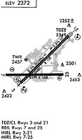
Runways
Runway Summary
| Runways: | 03/21 08/26 |
| Longest Runway: | 03/21 is 11002 ft (3353 m) long |
| Runways with an Instrument Approach: | 03, 21 |
GEG Airport Runway Details
| Runway 03/21 | 11002 ft x 150 ft (3353 m x 46 m) | |
| Runway Length Source: | NGS as of 03/01/2012 | |
| Surface: | Asphalt/Concrete - Excellent condition - Saw-cut or plastic grooved | |
| Runway Pavement Class: | 88 /R/B/W/T | |
| Runway Edge Lights: | High Intensity | |
Runway Weight Bearing Capacity (in thousands of pounds) |
||
| Single Wheel Landing Gear: | 200.0 | |
| Dual Wheel Landing Gear: | 200.0 | |
| Dual Tandem Wheel Landing Gear: | 400.0 | |
Runway 03 |
Runway 21 |
|
Elevation: |
2385.0 | 2322.4 |
Latitude: |
47-36-36.2909N | 47-37-52.3811N |
Longitude: |
117-33-00.2876W | 117-31-05.7573W |
|
Runway True Alignment: |
045 | 225 |
ILS Type: |
ILS/DME | ILS/DME |
Glide Path Angle: |
3.0 degrees | 3.0 degrees |
Traffic Pattern: |
Right | Left |
Runway Markings Type: |
Precision Instrument | Precision Instrument |
Runway Markings Condition: |
Good | Good |
Object at End: |
GND | |
Object Height: |
9 | |
Distance from End: |
325 | |
Object Centerline Offset: |
500 ft. left of centerline | |
Visual Glide Slope Indicators: |
4-Light PAPI On Left Side Of Runway | 4-Light PAPI On Left Side Of Runway |
Runway Visual Range (RVR): |
Touchdown, Midfield, Rollout | Touchdown, Midfield, Rollout |
Approach Light System: |
Standard 2,400 Foot High Intensity Approach Lighting System With Sequenced Flashers, Cat. II or III Config. | Standard 2,400 Foot High Intensity Approach Lighting System With Sequenced Flashers, Cat. II or III Config. |
Touchdown Lights: |
Yes | Yes |
Centerline Lights: |
Yes | Yes |
Threshold Crossing Height: |
69 | 73 |
Declared Distances |
||
Take Off Run Avbl. (TORA): |
11002 | 11002 |
Take Off Distance Avbl. (TODA): |
11002 | 11002 |
Actual Stop Dist. Avbl. (ASDA): |
11002 | 11002 |
Landing Dist. Avbl. (LDA): |
11002 | 11002 |
| Runway 08/26 | 8199 ft x 150 ft (2499 m x 46 m) | |
| Runway Length Source: | NGS as of 03/01/2012 | |
| Surface: | Asphalt/Concrete - Excellent condition - Saw-cut or plastic grooved | |
| Runway Pavement Class: | 40 /R/B/X/T | |
| Runway Edge Lights: | Medium Intensity | |
Runway Weight Bearing Capacity (in thousands of pounds) |
||
| Single Wheel Landing Gear: | 150.0 | |
| Dual Wheel Landing Gear: | 180.0 | |
| Dual Tandem Wheel Landing Gear: | 280.0 | |
Runway 08 |
Runway 26 |
|
Elevation: |
2376.2 | 2371.5 |
Latitude: |
47-37-01.0687N | 47-37-00.3642N |
Longitude: |
117-33-11.7639W | 117-31-12.1045W |
|
Runway True Alignment: |
090 | 270 |
Glide Path Angle: |
3.0 degrees | 3.0 degrees |
Traffic Pattern: |
Right | Left |
Runway Markings Type: |
Nonprecision Instrument | Nonprecision Instrument |
Runway Markings Condition: |
Good | Good |
Object Centerline Offset: |
500 ft. left of centerline | |
Visual Glide Slope Indicators: |
4-Light PAPI On Right Side Of Runway | 4-Light PAPI On Left Side Of Runway |
REIL: |
Yes | Yes |
Threshold Crossing Height: |
45 | 48 |
Declared Distances |
||
Take Off Run Avbl. (TORA): |
8199 | 8199 |
Take Off Distance Avbl. (TODA): |
8199 | 8199 |
Actual Stop Dist. Avbl. (ASDA): |
8199 | 8199 |
Landing Dist. Avbl. (LDA): |
8199 | 8199 |
Services
Airframe Repair: |
Minor |
Powerplant Repair: |
Minor |
Bottled Oxygen: |
None |
Fuel Available: |
100LL |
Landing Fees: |
No |
Parking: |
Hangars and tiedowns available |
Maps & Diagrams
GEG Sectional
Flight Planning
at skyvector.com
at skyvector.com