Location
Latitude: |
42-11-03.1710N (42.184214) |
Longitude: |
073-24-11.6660W (-73.403241) |
Elevation: |
739.4 feet MSL (225 m MSL) |
Magnetic Variation: |
13.1 W (as of April 2024 from WMM2020 model) |
Time Zone: |
UTC -5.0 (Standard Time) UTC -4.0 (Daylight Savings Time) |
From City: |
02 N.M. W of Great Barrington, Massachusetts |
Found On: |
New York Chart |
FAA Region: |
ANE |
Contacts
Manager: |
Privately owned: |
| JOSEPH SOLAN BOX 179, 70 EGREMONT PLAIN RD. GREAT BARRINGTON, MA 01230 413-528-1010 |
BERKSHIRE AVIATION ENTERP BOX 179, 70 EGREMONT PLAIN RD. GREAT BARRINGTON, MA 01230 413-528-1010 |
Operations
Airport Status: |
Operational |
Facility Use: |
Public |
Type: |
Airport |
Activation Date: |
04/1942 |
Control tower: |
No |
Attendance (Months/Days/Hours): |
Months/Days/Hours ALL/ALL/0800-1700 |
Boundary ARTCC: |
ZBW (Boston) |
Responsible ARTCC: |
ZBW (Boston) |
Lighting Schedule: |
SEE RMK |
Segmented Circle Indicator: |
No |
Traffic Pattern Altitude (MSL): |
1739 feet (530 m) |
NOTAMs Facility: |
BTV |
NOTAM-D Service: |
Yes |
International Airport of Entry: |
No |
Customs Landing Rights: |
No |
Military Landing Rights: |
No |
Civil/Military Joint Use: |
No |
Based Aircraft
| Single Engine: | 38 |
| Multi Engine: | 2 |
Annual Operations (as of 07/11/2022)
| Total Operations: | 12275 | |
| Air Taxi: | 175 | 1.4% |
| GA Local: | 10000 | 81.5% |
| GA Itinerant: | 2000 | 16.3% |
| Military Aircraft: | 100 | 0.8% |
Communications
| CTAF: | 122.800 |
| Unicom: | 122.800 |
| Approach: | ALBANY 132.825 132.825 |
| Departure: | ALBANY 132.825 132.825 |
Fixed Based Operators (FBOs) & Fuel
(Click on a business for detail)
Please help us keep this information up to date. This is a FREE SERVICE just like everything else on Airport Guide! If you see that a business needs to be added, modified, or deleted please fill out our Update Form.
To add, modify, or delete a business click here.
Please help us keep this information up to date. This is a FREE SERVICE just like everything else on Airport Guide! If you see that a business needs to be added, modified, or deleted please fill out our Update Form.
Area Code: 413 |
| Business Name | Frequency | Phone | Fuel Grade |
|---|---|---|---|
| Berkshire Aviation Enterprises, Inc.
Website Update FBO info |
Unicom 122.8 | 528-1010, 528-1061 | 100LL |

|
Phillips | 100LL - 2.43 USD per gallon on 10/16/01 |
Pumps 3% discount for cash |
Flight Service Stations
| Primary | Alternate | |
| FSS on Field: | N | |
| FSS Name (ID): | Burlington(BTV) | |
| Frequency: | ||
| Toll Free Phone: | 1-800-WX-BRIEF |
Instrument Procedures / Charts
FAA Terminal Procedures valid from 0901Z 03/21/24 to 0901Z 04/18/24.
There are various types of charts available for an airport. They are listed in the Page Type column. Here is a legend for those types:
APD - Airport Diagram
DP - Departure Procedure Charts
HOT - Hot Spots
IAP - Instrument Approach Procedure Charts
MIN - Minimums
STAR - Standard Terminal Arrival Charts
| Page Type | Page Name | Volume | Action Since Last Cycle |
|---|---|---|---|
| IAP | RNAV (GPS) RWY 11 | NE-1 | |
| IAP | RNAV (GPS)-B | NE-1 | |
| MIN | TAKEOFF MINIMUMS | NE-1 |
Terminal Procedures are only available for airports in several countries with more being added all the time. If you are looking for a specific country's charts, please send an email to support(at)airportguide.com stating the country name. This will be used to prioritize the implementation.
Navigation Aids (Navaids) near GBR
| Dist (NM) | ID | Morse Code | Name | Type | Freq | True Hdg | Mag Hdg |
|---|---|---|---|---|---|---|---|
| 0.1 | GBR | _ _ . _ . . . . _ . | Great Barrington | NDB | 395 | 204 | 217 |
| 14.8 | PFH | . _ _ . . . _ . . . . . | Philmont | NDB | 272 | 286 | 299 |
| 21.2 | CTR | _ . _ . _ . _ . | Chester | VOR-DME | 115.10 | 72 | 85 |
| 26.4 | PWL | . _ _ . . _ _ . _ . . | Pawling | VOR-DME | 114.30 | 199 | 212 |
| 30.6 | BAF | _ . . . . _ . . _ . | Barnes | VORTAC | 113.00 | 92 | 105 |
| 35.0 | BDL | _ . . . _ . . . _ . . | Bradley | VORTAC | 109.00 | 114 | 127 |
| 35.3 | BDL | _ . . . _ . . . _ . . | Bradley | VOT | 111.40 | 115 | 128 |
| 36.3 | IGN | . . _ _ . _ . | Kingston | VOR-DME | 117.60 | 211 | 224 |
| 38.1 | ALB | . _ . _ . . _ . . . | Albany | VORTAC | 115.30 | 332 | 345 |
| 38.3 | ALB | . _ . _ . . _ . . . | Albany | VOT | 108.20 | 331 | 344 |
| 39.0 | CEF | _ . _ . . . . _ . | Westover | TACAN | 114.00 | 88 | 101 |
| 43.0 | HFD | . . . . . . _ . _ . . | Hartford | VOT | 108.20 | 128 | 141 |
| 44.3 | PO | . _ _ . _ _ _ | Meier | NDB | 403 | 214 | 227 |
| 46.5 | HEU | . . . . . . . _ | Hunter | NDB | 356 | 329 | 342 |
| 48.7 | CAM | _ . _ . . _ _ _ | Cambridge | VOR-DME | 115.00 | 3 | 16 |
| 48.7 | SKU | . . . _ . _ . . _ | Stanwyck | NDB | 261 | 216 | 229 |
| 48.7 | SKU | . . . _ . _ . . _ | Stanwyck | FAN MARKER | 216 | 229 | |
| 49.8 | JWE | . _ _ _ . _ _ . | Clera | NDB | 362 | 164 | 177 |
| 50.2 | HFD | . . . . . . _ . _ . . | Hartford | VOR-DME | 114.90 | 130 | 143 |
| 50.6 | VWD | . . . _ . _ _ _ . . | Mount Snow | NDB | 224 | 27 | 40 |
Nearby Airports with Fuel
Notices to Airmen (NOTAMS)
Remarks
| A110*G | THIS AIRPORT HAS BEEN SURVEYED BY THE NATIONAL GEODETIC SURVEY. |
| A110-2 | TGLS NA. |
| A110-3 | PRACTICE VFR GPS RWY 11 NA WHEN RWY 29 IS IN USE FOR STUDENT TFC. |
| A110-4 | FOR CD CTC ALBANY APCH AT 518-862-2299. |
| A110-5 | WILDLIFE ON & INVOF ARPT. |
| A110-6 | COLD TEMPERATURE AIRPORT. ALTITUDE CORRECTION REQUIRED AT OR BELOW -20C. |
| A110-7 | COMPASS ROSE ADZY ONLY, NOT CRTFYD. |
| A24 | AVCARD NOT ACPTD. |
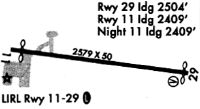
| A51-11 | LGTD THR RELCTD 170 FT; 2409 FT OF RWY USBL FOR NGT OPS. |
| A57-29 | APCH RATIO 19:1 TO DTHR. |
| A58-29 | +15 FT ROAD IN PRIM SFC AREA. |
| A81-APT | ACTVT REIL RWY 11; LIRL RWY 11/29 - 121.6. |
| E111 | FILED FOR RECORD PURPOSES ONLY. |
Runways
Runway Summary
| Runways: | 11/29 |
| Longest Runway: | 11/29 is 2579 ft (786 m) long |
| Runways with an Instrument Approach: |
GBR Airport Runway Details
| Runway 11/29 | 2579 ft x 50 ft (786 m x 15 m) | |
| Surface: | Asphalt - Fair condition - No special surface treatment | |
| Runway Edge Lights: | Low Intensity | |
Runway Weight Bearing Capacity (in thousands of pounds) |
||
| Single Wheel Landing Gear: | 8.0 | |
Runway 11 |
Runway 29 |
|
Elevation: |
739.4 | 733.6 |
Latitude: |
42-11-04.6080N | 42-11-01.7330N |
Longitude: |
073-24-28.6840W | 073-23-54.6470W |
|
Runway True Alignment: |
096 | 276 |
Glide Path Angle: |
0.0 degrees | 0.0 degrees |
Traffic Pattern: |
Left | Left |
Runway Markings Type: |
Basic | Basic |
Runway Markings Condition: |
Good | Good |
Object at End: |
TREES | TREES |
Object Height: |
30 | 57 |
Distance from End: |
425 | 1000 |
Object Centerline Offset: |
130 ft. right of centerline | 210 ft. right of centerline |
REIL: |
Yes | No |
Touchdown Lights: |
No | No |
Centerline Lights: |
No | No |
Threshold Elevation: |
739.4 | 734.2 |
Displaced Threshold: |
170 | 75 |
Threshold Latitude: |
42-11-04.4200N | 42-11-01.8390N |
Threshold Longitude: |
073-24-26.4500W | 073-23-55.8980W |
Services
Airframe Repair: |
Major |
Powerplant Repair: |
Major |
Bottled Oxygen: |
None |
Bulk Oxygen: |
None |
Fuel Available: |
100LL, Jet A-1 |
Landing Fees: |
No |
Parking: |
Hangars and tiedowns available |
Maps & Diagrams
GBR Sectional
Flight Planning
at skyvector.com
at skyvector.com