Location
Latitude: |
44-38-27.8485N (44.641069) |
Longitude: |
088-12-54.7293W (-88.215203) |
Elevation: |
783.0 feet MSL (239 m MSL) |
Magnetic Variation: |
4 W (as of April 2024 from WMM2020 model) |
Time Zone: |
UTC -6.0 (Standard Time) UTC -5.0 (Daylight Savings Time) |
From City: |
02 N.M. SSE of Pulaski, Wisconsin |
Found On: |
Green Bay Chart |
FAA Region: |
AGL |
Contacts
Manager: |
Privately owned: |
| BLUE SKIES AVIATION 3736 STATE ROAD 32 PULASKI, WI 54162 920-822-3644 |
PLANE AND SIMPLE LLP 5207 FRONTIER RD DENMARK, WI 54208 920-822-3644 |
Operations
Airport Status: |
Operational |
Facility Use: |
Public |
Type: |
Airport |
Activation Date: |
06/1965 |
Control tower: |
No |
Attendance (Months/Days/Hours): |
Months/Days/Hours ALL/ALL/DALGT |
Boundary ARTCC: |
ZMP (Minneapolis) |
Responsible ARTCC: |
ZMP (Minneapolis) |
Lighting Schedule: |
SEE RMK |
Segmented Circle Indicator: |
Yes |
Traffic Pattern Altitude (MSL): |
1783 feet (543 m) |
NOTAMs Facility: |
GRB |
NOTAM-D Service: |
Yes |
International Airport of Entry: |
No |
Customs Landing Rights: |
No |
Military Landing Rights: |
No |
Civil/Military Joint Use: |
No |
Based Aircraft
| Single Engine: | 31 |
| Ultralights: | 2 |
Annual Operations (as of 08/04/2023)
| Total Operations: | 3260 | |
| Air Taxi: | 10 | 0.3% |
| GA Local: | 3000 | 92.0% |
| GA Itinerant: | 250 | 7.7% |
Communications
| CTAF: | 122.900 |
| Approach: | GREEN BAY 119.4 119.4 119.4 MINNEAPOLIS ARTCC |
| Departure: | GREEN BAY 119.4 119.4 119.4 MINNEAPOLIS ARTCC |
- APCH/DEP SVC PRVDD BY MINNEAPOLIS ARTCC ON 125.55/370.9 (GREEN BAY RCAG) WHEN GREEN BAY APCH CLSD.
Fixed Based Operators (FBOs) & Fuel
(Click on a business for detail)
Please help us keep this information up to date. This is a FREE SERVICE just like everything else on Airport Guide! If you see that a business needs to be added, modified, or deleted please fill out our Update Form.
To add, modify, or delete a business click here.
Please help us keep this information up to date. This is a FREE SERVICE just like everything else on Airport Guide! If you see that a business needs to be added, modified, or deleted please fill out our Update Form.
Area Code: 920 |
| Business Name | Frequency | Phone | Fuel Grade |
|---|
Flight Service Stations
| Primary | Alternate | |
| FSS on Field: | N | |
| FSS Name (ID): | Green Bay(GRB) | |
| Frequency: | ||
| Toll Free Phone: | 1-800-WX-BRIEF |
Instrument Procedures / Charts
| Page Type | Page Name | Volume | Action Since Last Cycle |
|---|
Terminal Procedures are only available for airports in several countries with more being added all the time. If you are looking for a specific country's charts, please send an email to support(at)airportguide.com stating the country name. This will be used to prioritize the implementation.
Navigation Aids (Navaids) near 92C
| Dist (NM) | ID | Morse Code | Name | Type | Freq | True Hdg | Mag Hdg |
|---|---|---|---|---|---|---|---|
| 5.2 | GRB | _ _ . . _ . _ . . . | Green Bay | VORTAC | 115.50 | 170 | 174 |
| 12.1 | GR | _ _ . . _ . | Famis | NDB | 356 | 184 | 188 |
| 15.0 | SG | . . . _ _ . | Depre | NDB | 332 | 166 | 170 |
| 19.1 | OCQ | _ _ _ _ . _ . _ _ . _ | Oconto | NDB | 388 | 42 | 46 |
| 22.2 | CLI | _ . _ . . _ . . . . | Clintonville | NDB | 209 | 266 | 270 |
| 26.7 | AQ | . _ _ _ . _ | Kooky | NDB | 407 | 197 | 201 |
| 32.8 | AT | . _ _ | Gamie | NDB | 230 | 209 | 213 |
| 33.5 | TN | _ _ . | Tribe | NDB | 239 | 41 | 45 |
| 34.4 | MT | _ _ _ | Mawoc | NDB | 362 | 140 | 144 |
| 35.8 | SUE | . . . . . _ . | Sturgeon Bay | NDB | 414 | 70 | 74 |
| 38.4 | MTW | _ _ _ . _ _ | Manitowoc | DME | 111 | 143 | 147 |
| 39.0 | PCZ | . _ _ . _ . _ . _ _ . . | Waupaca | NDB | 382 | 242 | 246 |
| 40.4 | MNM | _ _ _ . _ _ | Menominee | DME | 109.6 | 36 | 40 |
| 41.7 | OSH | _ _ _ . . . . . . . | Oshkosh | VORTAC | 116.75 | 200 | 204 |
| 48.3 | OS | _ _ _ . . . | Pober | NDB | 395 | 197 | 201 |
| 49.2 | AIG | . _ . . _ _ . | Antigo | NDB | 347 | 309 | 313 |
| 54.7 | FAH | . . _ . . _ . . . . | Falls | DME | 110 | 163 | 167 |
| 56.5 | STE | . . . _ . | Stevens Point | VORTAC | 110.60 | 264 | 268 |
| 59.7 | AUW | . _ . . _ . _ _ | Wausau | VOR-DME | 111.60 | 282 | 286 |
| 61.2 | PH | . _ _ . . . . . | Bayye | NDB | 351 | 272 | 275 |
Nearby Airports with Fuel
Notices to Airmen (NOTAMS)
Remarks
| A110-1 | PAJA ON ARPT. |
| A110-2 | ULTRA-LIGHT FLYING ON & INVOF ARPT. |
| A110-3 | LIMITED LINE-OF-SIGHT BETWEEN RWY 04 & 12; RWY 04 & 30. |
| A110-4 | FOR CD CTC GREEN BAY APCH AT 920-431-5741, WHEN GREEN BAY APCH CLSD, FOR CD CTC MINNEAPOLIS ARTCC AT 651-463-5588. |
| A15 | EMAIL ADDRESS: TEKO299@AOL.COM (ALL LOWER CASEE) |
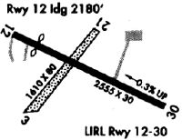
| A40-12/30 | RY 12/30 NSTD LIRL SPACED EVERY 300 FT. RY LIGHTED 2205 FT. |
| A57-04 | CTLN OBSTN EXCEEDS A 45 DEG SLP. |
| A57-12 | APCH RATIO 15:1 TO DSPLCD THR; 45 FT TREES 670 FT FM DSPLCD THR, 80 FT R. |
| A57-30 | APCH RATIO 10:1 TO DSPLCD THR; 60 FT TREES 380 FT FM DSPLCD THR, 125 FT L. |
| A58-12 | 30 FT TREES 170 FT FM RWY END, 25 FT R; RD 0-70 FT FM RWY END, 60-0 FT L. |
| A58-30 | 50 FT TREES 0-200 FT FM RWY END, 100 FT L. |
| A81-APT | ACTVT NSTD LIRL RY 12/30, 3 CLICKS ON 5 CLICKS OFF - CTAF. |
| A81-BCN | ACTVT ROTG BCN , 3 CLICKS ON 5 CLICKS OFF - CTAF. |
Runways
Runway Summary
| Runways: | 04/22 12/30 |
| Longest Runway: | 12/30 is 2955 ft (901 m) long |
| Runways with an Instrument Approach: |
92C Airport Runway Details
| Runway 04/22 | 1281 ft x 80 ft (390 m x 24 m) | |
| Runway Length Source: | OWNER as of 11/13/2023 | |
| Surface: | Turf - Fair condition - No special surface treatment | |
Runway 04 |
Runway 22 |
|
Elevation: |
774.0 | 777.0 |
Latitude: |
44-38-23.2299N | 44-38-33.3366N |
Longitude: |
088-13-05.7272W | 088-12-55.0773W |
Glide Path Angle: |
0.0 degrees | 0.0 degrees |
Traffic Pattern: |
Left | Left |
Object at End: |
TREE | TREES |
Object Height: |
50 | 25 |
Distance from End: |
50 | 0 |
Object Centerline Offset: |
80 ft. right of centerline | 95 ft. right of centerline |
REIL: |
No | No |
Touchdown Lights: |
No | No |
Centerline Lights: |
No | No |
| Runway 12/30 | 2955 ft x 38 ft (901 m x 12 m) | |
| Runway Length Source: | FAA OE/AAA as of 08/08/2017 | |
| Surface: | Turf - Fair condition - No special surface treatment | |
| Runway Edge Lights: | Non-standard lighting system Intensity | |
Runway 12 |
Runway 30 |
|
Elevation: |
782.2 | 773.8 |
Latitude: |
44-38-33.4600N | 44-38-21.8600N |
Longitude: |
088-13-11.0100W | 088-12-33.5300W |
|
Runway True Alignment: |
114 | 294 |
Glide Path Angle: |
0.0 degrees | 0.0 degrees |
Traffic Pattern: |
Left | Left |
Runway Markings Type: |
Basic | Basic |
Runway Markings Condition: |
Good | Good |
Object at End: |
TREES | TREES |
Object Height: |
35 | 60 |
Distance from End: |
200 | 200 |
Object Centerline Offset: |
80 ft. right of centerline | 95 ft. right of centerline |
REIL: |
No | No |
Touchdown Lights: |
No | No |
Centerline Lights: |
No | No |
Threshold Elevation: |
781.4 | 773.8 |
Displaced Threshold: |
375 | 380 |
Threshold Latitude: |
44-38-32.0000N | 44-38-23.3600N |
Threshold Longitude: |
088-13-06.2500W | 088-12-38.3400W |
Services
Airframe Repair: |
Major |
Powerplant Repair: |
Minor |
Bottled Oxygen: |
None |
Bulk Oxygen: |
None |
Fuel Available: |
100LL, Jet A+ |
Landing Fees: |
No |
Parking: |
Hangars and tiedowns available |
Maps & Diagrams
92C Sectional
Flight Planning
at skyvector.com
at skyvector.com