Location
Latitude: |
45-05-59.6910N (45.099914) |
Longitude: |
114-48-03.3440W (-114.800929) |
Elevation: |
4190.0 feet MSL (1277 m MSL) |
Magnetic Variation: |
12.7 E (as of April 2024 from WMM2020 model) |
Time Zone: |
UTC -7.0 (Standard Time) UTC -6.0 (Daylight Savings Time) |
From City: |
01 N.M. SW of Soldier Bar, Idaho |
Found On: |
Great Falls Chart |
FAA Region: |
ANM |
Contacts
Manager: |
Publicly owned: |
| PAYETTE FOREST AIR OFFICER P.O. BOX 1026 MC CALL, ID 83638 208-634-0746 |
U S FOREST SERVICE 324 25TH ST OGDEN, UT 84401 801-625-5511 |
Operations
Airport Status: |
Operational |
Facility Use: |
Public |
Type: |
Airport |
Activation Date: |
08/1947 |
Control tower: |
No |
Attendance (Months/Days/Hours): |
Months/Days/Hours Unattended |
Boundary ARTCC: |
ZLC (Salt Lake City) |
Responsible ARTCC: |
ZLC (Salt Lake City) |
Segmented Circle Indicator: |
No |
Traffic Pattern Altitude (MSL): |
5190 feet (1582 m) |
NOTAMs Facility: |
BOI |
NOTAM-D Service: |
Yes |
Military Landing Rights: |
No |
Civil/Military Joint Use: |
No |
Based Aircraft
Annual Operations (as of 06/30/2023)
| Total Operations: | 300 | |
| Air Taxi: | 100 | 33.3% |
| GA Itinerant: | 200 | 66.7% |
Communications
| CTAF: | 122.900 |
Fixed Based Operators (FBOs) & Fuel
(Click on a business for detail)
Please help us keep this information up to date. This is a FREE SERVICE just like everything else on Airport Guide! If you see that a business needs to be added, modified, or deleted please fill out our Update Form.
To add, modify, or delete a business click here.
Please help us keep this information up to date. This is a FREE SERVICE just like everything else on Airport Guide! If you see that a business needs to be added, modified, or deleted please fill out our Update Form.
Area Code: 208 |
| Business Name | Frequency | Phone | Fuel Grade |
|---|
Flight Service Stations
| Primary | Alternate | |
| FSS on Field: | N | |
| FSS Name (ID): | Boise(BOI) | |
| Frequency: | ||
| Toll Free Phone: | 1-800-WX-BRIEF |
Instrument Procedures / Charts
Terminal Procedures are only available for airports in several countries with more being added all the time. If you are looking for a specific country's charts, please send an email to support(at)airportguide.com stating the country name. This will be used to prioritize the implementation.
Navigation Aids (Navaids) near 85U
| Dist (NM) | ID | Morse Code | Name | Type | Freq | True Hdg | Mag Hdg |
|---|---|---|---|---|---|---|---|
| 30.7 | LKT | . _ . . _ . _ _ | Salmon | VOR-DME | 113.50 | 98 | 85 |
| 62.9 | DNJ | _ . . _ . . _ _ _ | Donnelly | VOR-DME | 116.20 | 252 | 239 |
| 90.8 | IDQ | . . _ . . _ _ . _ | Cottonwood | DME | 115.65 | 310 | 297 |
| 95.7 | DLN | _ . . . _ . . _ . | Dillon | VOR-DME | 113.00 | 83 | 71 |
Nearby Airports with Fuel
| Dist (NM) | Name (Airport IDs) | True Hdg | Mag Hdg | Fuel Grade |
|---|---|---|---|---|
| 39.0 | Lemhi County Airport (SMN KSMN SMN) |
87 | 75 | 100, Jet A |
| 42.6 | Challis Airport (CHL KLLJ LLJ) |
144 | 132 | 100, Jet A |
| 51.9 | West Fork Lodge Airport (4U7) |
28 | 15 | Mogas |
| 53.8 | Stanley Airport (2U7) |
186 | 173 | 100LL |
| 56.6 | Mc Call Municipal Airport (MYL KMYL MYL) |
257 | 244 | 100LL, Jet A, Jet A-1+ |
| 63.2 | Cascade Airport (U70) |
235 | 222 | 100LL, Jet A |
| 72.9 | Council Municipal Airport (U82) |
253 | 240 | 100LL |
| 75.0 | Ravalli County Airport (HRF) |
21 | 8 | 100LL, Jet A, Jet A+ |
| 75.1 | Idaho County Airport (KGIC GIC) |
312 | 299 | 100LL, Jet A |
| 84.3 | Kamiah Municipal Airport (S73) |
323 | 310 | 100LL |
| 85.5 | Cottonwood Municipal Airport (S84) |
311 | 298 | 100LL |
| 91.1 | Stevensville Airport (32S) |
19 | 6 | 100LL |
| 95.5 | Dillon Airport (DLN KDLN DLN) |
83 | 71 | 100LL, Jet A |
| 98.2 | Friedman Meml Airport (SUN KSUN SUN) |
167 | 155 | 100LL, Jet A-1+ |
| 98.5 | Craigmont Municipal Airport (S89) |
314 | 301 | 100LL |
Notices to Airmen (NOTAMS)
Remarks
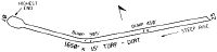
| A110-1 | STEEP CANYON WALLS IN ALL DRCTNS. |
| A110-3 | ARPT ON BENCH 500 FT ABOVE BIG CREEK ON S SIDE. |
| A110-4 | CABIN CREEK ARPT APPROX 7 MILES WEST UP BIG CREEK CANYON. |
| A110-5 | WEST 1/3 OF RY HAS 4 DEG SLOPE DOWN TO THE NORTH. |
| A110-6 | GO-AROUNDS NOT RECOMMENDED. |
| A110-7 | NO TELEPHONE AVBL AT ARPT. |
| A110-8 | FOR CD CTC SALT LAKE ARTCC AT 801-320-2568. |
| A110-9 | RWY 7/25 HAS TWO BIG HUMPS ARND THE MID-FLD & TO THE W OF IT. |
| A30-07/25 | SHARP DOG LEG ON WEST 1/3 OF RY TO THE NORTH. LAND RY 25; TKOF RY 07. |
Runways
Runway Summary
| Runways: | 07/25 |
| Longest Runway: | 07/25 is 1650 ft (503 m) long |
| Runways with an Instrument Approach: |
85U Airport Runway Details
| Runway 07/25 | 1650 ft x 15 ft (503 m x 5 m) | |
| Surface: | Dirt - Fair condition - No special surface treatment | |
Runway 07 |
Runway 25 |
|
Glide Path Angle: |
0.0 degrees | 0.0 degrees |
Traffic Pattern: |
Left | Left |
Object at End: |
TREES | HILL |
Object Height: |
90 | 200 |
Distance from End: |
200 | 1100 |
Object Centerline Offset: |
0 ft. left and right of centerline | 0 ft. left and right of centerline |
Services
Bottled Oxygen: |
None |
Bulk Oxygen: |
None |
Fuel Available: |
100LL |
Landing Fees: |
No |
Parking: |
Tiedowns available |
Maps & Diagrams
85U Sectional
Flight Planning
at skyvector.com
at skyvector.com