Location
Latitude: |
41-26-58.5440N (41.449596) |
Longitude: |
081-03-46.5640W (-81.062934) |
Elevation: |
1174.3 feet MSL (358 m MSL) |
Magnetic Variation: |
8.8 W (as of April 2024 from WMM2020 model) |
Time Zone: |
UTC -5.0 (Standard Time) UTC -4.0 (Daylight Savings Time) |
From City: |
01 N.M. SE of Middlefield, Ohio |
Found On: |
Detroit Chart |
FAA Region: |
AGL |
Contacts
Manager: |
Publicly owned: |
| RICHARD BLAMER PO BOX 1308 MIDDLEFIELD, OH 44062-1308 440-632-1884 |
GEAUGA CO BOARD OF COMM COURTHOUSE ANNEX, 231 MAIN ST CHARDON, OH 44024-1263 440-285-2222 |
Operations
Airport Status: |
Operational |
Facility Use: |
Public |
Type: |
Airport |
Control tower: |
No |
Attendance (Months/Days/Hours): |
Months/Days/Hours ALL/MON-FRI/0900-1700 IREG |
Boundary ARTCC: |
ZOB (Cleveland) |
Responsible ARTCC: |
ZOB (Cleveland) |
Lighting Schedule: |
SEE RMK |
Segmented Circle Indicator: |
No |
Traffic Pattern Altitude (MSL): |
2174 feet (663 m) |
NOTAMs Facility: |
CLE |
NOTAM-D Service: |
Yes |
International Airport of Entry: |
No |
Customs Landing Rights: |
No |
Military Landing Rights: |
No |
Civil/Military Joint Use: |
No |
Based Aircraft
| Single Engine: | 40 |
| Multi Engine: | 2 |
| GA Helicopters: | 1 |
| Gliders: | 5 |
Annual Operations (as of 06/29/2023)
| Total Operations: | 20800 | |
| Air Taxi: | 800 | 3.8% |
| GA Local: | 18000 | 86.5% |
| GA Itinerant: | 1500 | 7.2% |
| Military Aircraft: | 500 | 2.4% |
Communications
| CTAF: | 123.000 |
| Unicom: | 123.000 |
| Approach: | CLEVELAND 125.35 125.35 |
| Departure: | CLEVELAND 125.35 125.35 |
Fixed Based Operators (FBOs) & Fuel
(Click on a business for detail)
Please help us keep this information up to date. This is a FREE SERVICE just like everything else on Airport Guide! If you see that a business needs to be added, modified, or deleted please fill out our Update Form.
To add, modify, or delete a business click here.
Please help us keep this information up to date. This is a FREE SERVICE just like everything else on Airport Guide! If you see that a business needs to be added, modified, or deleted please fill out our Update Form.
Area Code: 216 |
| Business Name | Frequency | Phone | Fuel Grade |
|---|
Flight Service Stations
| Primary | Alternate | |
| FSS on Field: | N | |
| FSS Name (ID): | Cleveland(CLE) | |
| Frequency: | ||
| Toll Free Phone: | 1-800-WX-BRIEF |
Instrument Procedures / Charts
FAA Terminal Procedures valid from 0901Z 03/21/24 to 0901Z 04/18/24.
There are various types of charts available for an airport. They are listed in the Page Type column. Here is a legend for those types:
APD - Airport Diagram
DP - Departure Procedure Charts
HOT - Hot Spots
IAP - Instrument Approach Procedure Charts
MIN - Minimums
STAR - Standard Terminal Arrival Charts
| Page Type | Page Name | Volume | Action Since Last Cycle |
|---|---|---|---|
| IAP | RNAV (GPS) RWY 11 | EC-2 | |
| IAP | RNAV (GPS) RWY 29 | EC-2 | |
| MIN | TAKEOFF MINIMUMS | EC-2 |
Terminal Procedures are only available for airports in several countries with more being added all the time. If you are looking for a specific country's charts, please send an email to support(at)airportguide.com stating the country name. This will be used to prioritize the implementation.
Navigation Aids (Navaids) near 7G8
| Dist (NM) | ID | Morse Code | Name | Type | Freq | True Hdg | Mag Hdg |
|---|---|---|---|---|---|---|---|
| 6.1 | CXR | _ . _ . _ . . _ . _ . | Chardon | VOR-DME | 112.70 | 311 | 320 |
| 18.9 | YNG | _ . _ _ _ . _ _ . | Youngstown | VORTAC | 109.00 | 112 | 121 |
| 19.9 | LQL | . _ . . _ _ . _ . _ . . | Lakeland | NDB | 263 | 314 | 323 |
| 21.4 | ACO | . _ _ . _ . _ _ _ | Akron | VOR-DME | 114.40 | 196 | 205 |
| 23.4 | JFN | . _ _ _ . . _ . _ . | Jefferson | DME | 115.2 | 37 | 46 |
| 25.8 | YN | _ . _ _ _ . | Fetch | NDB | 338 | 125 | 134 |
| 27.1 | AK | . _ _ . _ | Akron | NDB | 362 | 212 | 221 |
| 29.8 | HBD | . . . . _ . . . _ . . | Hubbard | NDB | 408 | 126 | 135 |
| 35.5 | CLE | _ . _ . . _ . . . | Cleveland | VOT | 110.40 | 267 | 276 |
| 36.3 | CAK | _ . _ . . _ _ . _ | Akron/Canton Regional | VOT | 110.60 | 208 | 217 |
| 38.8 | UCP | . . _ _ . _ . . _ _ . | Castle | NDB | 272 | 131 | 140 |
| 45.7 | BSV | _ . . . . . . . . . _ | Briggs | VOR-DME | 112.40 | 201 | 210 |
| 48.5 | ERI | . . _ . . . | Erie | TACAN | 109.40 | 45 | 54 |
| 49.8 | DJB | _ . . . _ _ _ _ . . . | Dryer | VOR-DME | 113.60 | 264 | 272 |
| 50.6 | ERI | . . _ . . . | Esmer | NDB | 349 | 45 | 54 |
| 53.7 | EWC | . . _ _ _ . _ . | Ellwood City | VOR-DME | 115.80 | 133 | 142 |
| 54.3 | FKL | . . _ . _ . _ . _ . . | Franklin | VOR | 109.60 | 90 | 99 |
| 58.8 | CQD | _ . _ . _ _ . _ _ . . | Cascade | NDB | 372 | 46 | 55 |
| 61.1 | AAU | . _ . _ . . _ | Ashland | NDB | 329 | 241 | 249 |
| 65.7 | MLR | _ _ . _ . . . _ . | Millersburg/Dcmsnd | NDB | 382 | 214 | 222 |
Nearby Airports with Fuel
Notices to Airmen (NOTAMS)
Remarks
| A110-3 | PARL TWY EAST OF TEE HNGRS CLSD PERMLY. |
| A110-6 | EXTSV GLDR ACT ON & INVOF ARPT. |
| A110-7 | DEER, BIRDS, & OTR WILDLIFE ON & INVOF ARPT. |
| A110-8 | FOR CD CTC CLEVELAND APCH AT 216-352-2323. |
| A110-9 | ADZY ONLY WX AVBL - 4 CLICKS CTAF. |
| A14 | 7G8MANAGER@GMAIL.COM. |
| A16 | CELL 216-509-8858. |
| A57-11 | APCH RATIO 16:1 TO DTHR. |
| A58-11 | +3-6 FT BRUSH, 0-140 FT DIST, 220 FT L. |
| A70-FUEL-10 | 0LL 100LL AVBL H24 VIA CREDIT CARD. |
| A75 | SUBJ AVBLTY. |
| A75 1 | ROPES NOT PRVDD. |
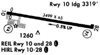
| A81-APT | ACTVT REIL RWY 11 & 29; PAPI RWY 29; MIRL RWY 11/29 - CTAF. |
Runways
Runway Summary
| Runways: | 11/29 |
| Longest Runway: | 11/29 is 3500 ft (1067 m) long |
| Runways with an Instrument Approach: |
7G8 Airport Runway Details
| Runway 11/29 | 3500 ft x 65 ft (1067 m x 20 m) | |
| Runway Length Source: | 3RD PARTY SURVEY as of 01/21/2020 | |
| Surface: | Asphalt - Good condition - No special surface treatment | |
| Runway Edge Lights: | Medium Intensity | |
Runway Weight Bearing Capacity (in thousands of pounds) |
||
| Single Wheel Landing Gear: | 18.5 | |
Runway 11 |
Runway 29 |
|
Elevation: |
1174.3 | 1157.9 |
Latitude: |
41-27-01.5319N | 41-26-55.5551N |
Longitude: |
081-04-09.1941W | 081-03-23.9341W |
|
Runway True Alignment: |
100 | 280 |
Glide Path Angle: |
0.0 degrees | 3.0 degrees |
Traffic Pattern: |
Left | Left |
Runway Markings Type: |
Nonprecision Instrument | Nonprecision Instrument |
Runway Markings Condition: |
Good | Good |
Object at End: |
ANT | |
Object Height: |
45 | |
Object Marked/Lighted?: |
Lighted | |
Distance from End: |
551 | |
Object Centerline Offset: |
160 ft. right of centerline | |
Visual Glide Slope Indicators: |
2-Light PAPI On Left Side Of Runway | |
REIL: |
Yes | Yes |
Touchdown Lights: |
No | No |
Centerline Lights: |
No | No |
Threshold Crossing Height: |
23 | |
Threshold Elevation: |
1172.0 | |
Displaced Threshold: |
179 | |
Threshold Latitude: |
41-27-01.2265N | |
Threshold Longitude: |
081-04-06.8793W |
Services
Airframe Repair: |
Major |
Powerplant Repair: |
Major |
Bottled Oxygen: |
None |
Bulk Oxygen: |
None |
Fuel Available: |
100LL |
Landing Fees: |
No |
Parking: |
Hangars and tiedowns available |
Maps & Diagrams
7G8 Sectional
Flight Planning
at skyvector.com
at skyvector.com