Location
Latitude: |
40-50-24.6000N (40.840167) |
Longitude: |
081-18-30.0000W (-81.308333) |
Elevation: |
1135.0 feet MSL (346 m MSL) |
Magnetic Variation: |
8.5 W (as of April 2024 from WMM2020 model) |
Time Zone: |
UTC -5.0 (Standard Time) UTC -4.0 (Daylight Savings Time) |
From City: |
04 N.M. E of Canton, Ohio |
Found On: |
Detroit Chart |
FAA Region: |
AGL |
Contacts
Manager: |
Publicly owned: |
| PAT HEMPHILL 4500 ATLANTIC BLVD NORTHEAST CANTON, OH 44705-4374 234-804-1440 |
STARK CO COMM 4500 ATLANTIC BLVD NE CANTON, OH 44705-4374 330-430-3800 |
Operations
Airport Status: |
Operational |
Facility Use: |
Public |
Type: |
Heliport |
Activation Date: |
03/1971 |
Control tower: |
No |
Attendance (Months/Days/Hours): |
Months/Days/Hours ALL/ALL/ALL |
Boundary ARTCC: |
ZOB (Cleveland) |
Responsible ARTCC: |
ZOB (Cleveland) |
Segmented Circle Indicator: |
No |
Traffic Pattern Altitude (MSL): |
2135 feet (651 m) |
NOTAMs Facility: |
CLE |
NOTAM-D Service: |
Yes |
Based Aircraft
Annual Operations (as of 07/29/2020)
| Total Operations: | 66 | |
| GA Itinerant: | 56 | 84.8% |
| Military Aircraft: | 10 | 15.2% |
Communications
| CTAF: | 122.900 |
Fixed Based Operators (FBOs) & Fuel
(Click on a business for detail)
Please help us keep this information up to date. This is a FREE SERVICE just like everything else on Airport Guide! If you see that a business needs to be added, modified, or deleted please fill out our Update Form.
To add, modify, or delete a business click here.
Please help us keep this information up to date. This is a FREE SERVICE just like everything else on Airport Guide! If you see that a business needs to be added, modified, or deleted please fill out our Update Form.
Area Code: 330 |
| Business Name | Frequency | Phone | Fuel Grade |
|---|
Flight Service Stations
| Primary | Alternate | |
| FSS on Field: | N | |
| FSS Name (ID): | Cleveland(CLE) | |
| Frequency: | ||
| Toll Free Phone: | 1-800-WX-BRIEF |
Instrument Procedures / Charts
Terminal Procedures are only available for airports in several countries with more being added all the time. If you are looking for a specific country's charts, please send an email to support(at)airportguide.com stating the country name. This will be used to prioritize the implementation.
Navigation Aids (Navaids) near 5D1
| Dist (NM) | ID | Morse Code | Name | Type | Freq | True Hdg | Mag Hdg |
|---|---|---|---|---|---|---|---|
| 7.6 | CAK | _ . _ . . _ _ . _ | Akron/Canton Regional | VOT | 110.60 | 307 | 315 |
| 8.2 | BSV | _ . . . . . . . . . _ | Briggs | VOR-DME | 112.40 | 223 | 231 |
| 14.2 | AK | . _ _ . _ | Akron | NDB | 362 | 345 | 354 |
| 16.8 | ACO | . _ _ . _ . _ _ _ | Akron | VOR-DME | 114.40 | 16 | 25 |
| 31.3 | MLR | _ _ . _ . . . _ . | Millersburg/Dcmsnd | NDB | 382 | 235 | 243 |
| 37.5 | CTW | _ . _ . _ . _ _ | Newcomerstown | DME | 111.8 | 191 | 199 |
| 38.6 | CFX | _ . _ . . . _ . _ . . _ | Cadiz | NDB | 239 | 159 | 168 |
| 38.8 | YN | _ . _ _ _ . | Fetch | NDB | 338 | 55 | 64 |
| 39.9 | HBD | . . . . _ . . . _ . . | Hubbard | NDB | 408 | 61 | 70 |
| 41.1 | YNG | _ . _ _ _ . _ _ . | Youngstown | VORTAC | 109.00 | 44 | 53 |
| 41.1 | CXR | _ . _ . _ . . _ . _ . | Chardon | VOR-DME | 112.70 | 9 | 18 |
| 41.9 | UCP | . . _ _ . _ . . _ _ . | Castle | NDB | 272 | 74 | 83 |
| 42.5 | CLE | _ . _ . . _ . . . | Cleveland | VOT | 110.40 | 324 | 332 |
| 43.5 | AAU | . _ . _ . . _ | Ashland | NDB | 329 | 280 | 288 |
| 48.5 | HLG | . . . . . _ . . _ _ . | Wheeling | VOR-DME | 114.25 | 135 | 144 |
| 49.6 | DJB | _ . . . _ _ _ _ . . . | Dryer | VOR-DME | 113.60 | 309 | 317 |
| 49.8 | EWC | . . _ _ _ . _ . | Ellwood City | VOR-DME | 115.80 | 90 | 99 |
| 50.6 | LQL | . _ . . _ _ . _ . _ . . | Lakeland | NDB | 263 | 356 | 365 |
| 51.8 | MF | _ _ . . _ . | Manns | NDB | 372 | 265 | 273 |
| 54.2 | AIR | . _ . . . _ . | Bellaire | VOR-DME | 117.10 | 155 | 164 |
Nearby Airports with Fuel
Notices to Airmen (NOTAMS)
Remarks
| A110-1 | INGRESS/EGRESS CLKWS FM PAD. INGRESS NE FATO 220 DEG, EGRESS NE FATO 040 DEG |
| A110-2 | FOR CD CTC CLEVELAND APCH AT 216-352-2323, WHEN APCH CLSD CTC CLEVELAND ARTCC AT 440-774-0223. |
| A16 | AMGR CELL 234-804-1440. |
| A33-H1 | EXTSV CRACKING, LOOSE STONES. |
| A42-H1 | FADED. |
| A42-H1 1 | HELI MKD WITH H. |
| A52-H1 | ALSO +230 FT LGTD TWR, 465 FT SW; +271 FT LGTD TWR, 1364 FT SE. |
| E111 | VFR ONLY. |
Runways
Runway Summary
| Runways: | H1 |
| Longest Runway: | H1 is 120 ft (37 m) long |
| Runways with an Instrument Approach: |
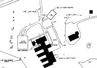
5D1 Airport Runway Details
| Helipad H1 | 120 ft x 75 ft (37 m x 23 m) | |
| Surface: | Asphalt - Poor condition - No special surface treatment | |
Helipad H1 |
||
Elevation: |
1135.0 | |
Latitude: |
40-50-24.6000N | |
Longitude: |
081-18-30.0000W | |
Glide Path Angle: |
0.0 degrees | 0.0 degrees |
Runway Markings Type: |
Basic | |
Runway Markings Condition: |
Poor | |
Object at End: |
POLE | |
Object Height: |
28 | |
Distance from End: |
85 | |
Object Centerline Offset: |
10 ft. right of centerline |
Services
Airframe Repair: |
Minor |
Powerplant Repair: |
Minor |
Bottled Oxygen: |
None |
Bulk Oxygen: |
None |
Fuel Available: |
100LL, Jet A, Jet A+ |
Landing Fees: |
No |
Parking: |
Hangars and tiedowns available |
Maps & Diagrams
5D1 Sectional
Flight Planning
at skyvector.com
at skyvector.com