Location
Latitude: |
41-20-09.6000N (41.336) |
Longitude: |
083-43-23.5000W (-83.723194) |
Elevation: |
690.0 feet MSL (210 m MSL) |
Magnetic Variation: |
6.9 W (as of April 2024 from WMM2020 model) |
Time Zone: |
UTC -5.0 (Standard Time) UTC -4.0 (Daylight Savings Time) |
From City: |
04 N.M. SW of Bowling Green, Ohio |
Found On: |
Detroit Chart |
FAA Region: |
AGL |
Contacts
Manager: |
Privately owned: |
| BERNIE STEINBAUGH 16662 HODGMAN RD WESTON, OH 43569-9723 419-353-4732 |
BERNIE STEINBAUGH 16662 HODGMAN RD WESTON, OH 43569-9723 419-353-4732 |
Operations
Airport Status: |
Operational |
Facility Use: |
Public |
Type: |
Airport |
Activation Date: |
11/1960 |
Control tower: |
No |
Attendance (Months/Days/Hours): |
Months/Days/Hours ALL/ALL/IREG |
Boundary ARTCC: |
ZOB (Cleveland) |
Responsible ARTCC: |
ZOB (Cleveland) |
Lighting Schedule: |
SEE RMK |
Segmented Circle Indicator: |
No |
Traffic Pattern Altitude (MSL): |
1690 feet (515 m) |
NOTAMs Facility: |
CLE |
NOTAM-D Service: |
Yes |
Based Aircraft
| Single Engine: | 3 |
Annual Operations (as of 09/23/2022)
| Total Operations: | 36 | |
| GA Local: | 12 | 33.3% |
| GA Itinerant: | 24 | 66.7% |
Communications
| CTAF: | 122.900 |
Fixed Based Operators (FBOs) & Fuel
(Click on a business for detail)
Please help us keep this information up to date. This is a FREE SERVICE just like everything else on Airport Guide! If you see that a business needs to be added, modified, or deleted please fill out our Update Form.
To add, modify, or delete a business click here.
Please help us keep this information up to date. This is a FREE SERVICE just like everything else on Airport Guide! If you see that a business needs to be added, modified, or deleted please fill out our Update Form.
Area Code: 419 |
| Business Name | Frequency | Phone | Fuel Grade |
|---|
Flight Service Stations
| Primary | Alternate | |
| FSS on Field: | N | |
| FSS Name (ID): | Cleveland(CLE) | |
| Frequency: | ||
| Toll Free Phone: | 1-800-WX-BRIEF |
Instrument Procedures / Charts
Terminal Procedures are only available for airports in several countries with more being added all the time. If you are looking for a specific country's charts, please send an email to support(at)airportguide.com stating the country name. This will be used to prioritize the implementation.
Navigation Aids (Navaids) near 3D8
| Dist (NM) | ID | Morse Code | Name | Type | Freq | True Hdg | Mag Hdg |
|---|---|---|---|---|---|---|---|
| 7.9 | VWV | . . . _ . _ _ . . . _ | Waterville | VOR-DME | 113.10 | 28 | 35 |
| 15.8 | TO | _ _ _ _ | Tophr | NDB | 219 | 325 | 332 |
| 15.8 | TOL | _ _ _ _ . _ . . | Toledo | TACAN | 112.50 | 347 | 354 |
| 17.1 | FZI | . . _ . _ _ . . . . | Fostoria | NDB | 379 | 120 | 127 |
| 19.0 | BNR | _ . . . _ . . _ . | Benton Ridge | NDB | 334 | 172 | 179 |
| 22.9 | FBC | . . _ . _ . . . _ . _ . | Flag City | VORTAC | 108.20 | 183 | 190 |
| 24.6 | USE | . . _ . . . . | Fulton | NDB | 375 | 311 | 318 |
| 27.1 | TII | _ . . . . | Tiffin | NDB | 269 | 122 | 129 |
| 35.8 | ADG | . _ _ . . _ _ . | Adrian | NDB | 278 | 333 | 340 |
| 39.3 | AOH | . _ _ _ _ . . . . | Allen County | VOR | 108.40 | 196 | 203 |
| 40.0 | PCW | . _ _ . _ . _ . . _ _ | Port Clinton | NDB | 423 | 73 | 80 |
| 42.5 | TCU | _ _ . _ . . . _ | Tecumseh | NDB | 239 | 350 | 357 |
| 44.3 | CRL | _ . _ . . _ . . _ . . | Carleton | VOR-DME | 115.70 | 15 | 22 |
| 48.5 | SKY | . . . _ . _ _ . _ _ | Sandusky | VOR-DME | 109.20 | 82 | 89 |
| 49.3 | VFU | . . . _ . . _ . . . _ | Stanley | NDB | 411 | 235 | 242 |
| 52.5 | BUD | _ . . . . . _ _ . . | Buckeye | VOR | 109.80 | 145 | 152 |
| 52.5 | RYS | . _ . _ . _ _ . . . | Grosse Ile | NDB | 419 | 28 | 35 |
| 52.7 | RUV | . _ . . . _ . . . _ | Rushsylvania | NDB | 326 | 177 | 184 |
| 54.6 | YIP | _ . _ _ . . . _ _ . | Willow Run | VOT | 108.85 | 9 | 16 |
| 55.0 | DXO | _ . . _ . . _ _ _ _ | Detroit | VOR-DME | 113.40 | 16 | 23 |
Nearby Airports with Fuel
Notices to Airmen (NOTAMS)
Remarks
| A110*G | THIS AIRPORT HAS BEEN SURVEYED BY THE NATIONAL GEODETIC SURVEY. |
| A110-2 | NO STUDENT OPS. |
| A110-3 | FOR CD CTC TOLEDO APCH AT 419-865-1495. |
| A110-4 | CTC AMGR TO VFY FLD CONDS BFR ARR. |
| A33-09/27 | GRASS GROWING INTO SOME OF THE ASPH. |
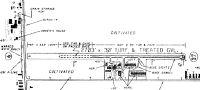
| A33-09/27 1 | LDG AREA TURF/GRVL & ASPH; WEST 550 FT TURF, THEN 800 FT TURF/ASPH, THEN 625 FT ASPH/GRVL, THEN EAST 675 FT TURF/ASPH. |
| A40-09/27 | NSTD LIRL DUE TO SOLAR LGTS. |
| A81-APT | NSTD LIRL RWY 09/27 OTS INDEFLY. |
| E111 | PRVDD RWY 09/27 MOVED NORTH TO PRVD ADNL CLNC FM ELEVATORS ON SOUTH SIDE; OBSTS IN APCH SLP ARE REMOVED/LWRD OR RWY THR DSPLCD/MKD TO PRVD A MNM 20:1 APCH CLNC OF OBSTS. |
Runways
Runway Summary
| Runways: | 09/27 |
| Longest Runway: | 09/27 is 2623 ft (799 m) long |
| Runways with an Instrument Approach: |
3D8 Airport Runway Details
| Runway 09/27 | 2623 ft x 30 ft (799 m x 9 m) | |
| Runway Length Source: | NGS as of 11/28/2001 | |
| Surface: | Turf/Gravel - Fair condition - No special surface treatment | |
| Runway Edge Lights: | Non-standard lighting system Intensity | |
Runway Weight Bearing Capacity (in thousands of pounds) |
||
| Single Wheel Landing Gear: | 5.0 | |
Runway 09 |
Runway 27 |
|
Elevation: |
684.5 | 689.5 |
Latitude: |
41-20-09.8846N | 41-20-09.2303N |
Longitude: |
083-43-40.6750W | 083-43-06.3048W |
|
Runway True Alignment: |
091 | 271 |
Glide Path Angle: |
0.0 degrees | 0.0 degrees |
Traffic Pattern: |
Right | Left |
Object at End: |
PLINE | CROPS |
Object Height: |
29 | 15 |
Object Marked/Lighted?: |
Marked | |
Distance from End: |
48 | 0 |
Object Centerline Offset: |
0 ft. left and right of centerline | 45 ft. left and right of centerline |
REIL: |
No | No |
Touchdown Lights: |
No | No |
Centerline Lights: |
No | No |
Services
Airframe Repair: |
None |
Powerplant Repair: |
None |
Bottled Oxygen: |
None |
Bulk Oxygen: |
None |
Fuel Available: |
100LL, Jet A+ |
Landing Fees: |
No |
Parking: |
Hangars and tiedowns available |
Maps & Diagrams
3D8 Sectional
Flight Planning
at skyvector.com
at skyvector.com