Location
Latitude: |
37-54-24.7000N (37.906861) |
Longitude: |
100-31-53.1000W (-100.531417) |
Elevation: |
2814.0 feet MSL (858 m MSL) |
Magnetic Variation: |
5 E (as of April 2024 from WMM2020 model) |
Time Zone: |
UTC -6.0 (Standard Time) UTC -5.0 (Daylight Savings Time) |
From City: |
06 N.M. NW of Ingalls, Kansas |
Found On: |
Wichita Chart |
FAA Region: |
ACE |
Contacts
Manager: |
Publicly owned: |
| LEONARD RODENDER BOX 103 INGALLS, KS 67853 (620) 335-5118 |
CITY OF INGALLS BOX 103 INGALLS, KS 67853 620-335-5118 |
Operations
Airport Status: |
Operational |
Facility Use: |
Public |
Type: |
Airport |
Activation Date: |
02/1944 |
Control tower: |
No |
Attendance (Months/Days/Hours): |
Months/Days/Hours Unattended |
Boundary ARTCC: |
ZKC (Kansas City) |
Responsible ARTCC: |
ZKC (Kansas City) |
Segmented Circle Indicator: |
No |
Traffic Pattern Altitude (MSL): |
3814 feet (1163 m) |
NOTAMs Facility: |
ICT |
NOTAM-D Service: |
Yes |
International Airport of Entry: |
No |
Customs Landing Rights: |
No |
Military Landing Rights: |
Yes |
Civil/Military Joint Use: |
No |
Based Aircraft
| Single Engine: | 3 |
Annual Operations (as of 08/31/2021)
| Total Operations: | 1200 | |
| GA Local: | 1200 | 100.0% |
Communications
| CTAF: | 122.900 |
Fixed Based Operators (FBOs) & Fuel
(Click on a business for detail)
Please help us keep this information up to date. This is a FREE SERVICE just like everything else on Airport Guide! If you see that a business needs to be added, modified, or deleted please fill out our Update Form.
To add, modify, or delete a business click here.
Please help us keep this information up to date. This is a FREE SERVICE just like everything else on Airport Guide! If you see that a business needs to be added, modified, or deleted please fill out our Update Form.
Area Code: 620 |
| Business Name | Frequency | Phone | Fuel Grade |
|---|
Flight Service Stations
| Primary | Alternate | |
| FSS on Field: | N | |
| FSS Name (ID): | Wichita(ICT) | |
| Frequency: | ||
| Toll Free Phone: | 1-800-WX-BRIEF |
Instrument Procedures / Charts
Terminal Procedures are only available for airports in several countries with more being added all the time. If you are looking for a specific country's charts, please send an email to support(at)airportguide.com stating the country name. This will be used to prioritize the implementation.
Navigation Aids (Navaids) near 30K
| Dist (NM) | ID | Morse Code | Name | Type | Freq | True Hdg | Mag Hdg |
|---|---|---|---|---|---|---|---|
| 9.2 | GCK | _ _ . _ . _ . _ . _ | Garden City | VORTAC | 113.30 | 274 | 269 |
| 10.3 | GC | _ _ . _ . _ . | Pieve | NDB | 347 | 242 | 237 |
| 25.1 | DDC | _ . . _ . . _ . _ . | Dodge City | VORTAC | 108.20 | 97 | 92 |
| 38.3 | TQK | _ _ _ . _ _ . _ | Scott City | NDB | 256 | 334 | 329 |
| 43.8 | ULS | . . _ . _ . . . . . | Ulysses | NDB | 395 | 245 | 240 |
| 55.8 | LBL | . _ . . _ . . . . _ . . | Liberal | TACAN | 112.30 | 202 | 197 |
| 59.3 | JHN | . _ _ _ . . . . _ . | Bear Creek | NDB | 341 | 254 | 249 |
| 60.0 | HQG | . . . . _ _ . _ _ _ . | Hugoton | NDB | 365 | 222 | 217 |
| 60.1 | LB | . _ . . _ . . . | Panck | NDB | 383 | 199 | 194 |
| 70.5 | LQR | . _ . . _ _ . _ . _ . | Larned | NDB | 296 | 74 | 69 |
| 73.6 | OEL | _ _ _ . . _ . . | Oakley | NDB | 380 | 349 | 344 |
| 76.2 | BFK | _ . . . . . _ . _ . _ | Buffalo | NDB | 215 | 144 | 139 |
| 79.4 | HY | . . . . _ . _ _ | Nette | NDB | 374 | 48 | 43 |
| 81.5 | HIL | . . . . . . . _ . . | Hilyn | NDB | 338 | 70 | 65 |
| 81.7 | HYS | . . . . _ . _ _ . . . | Hays | VORTAC | 110.40 | 45 | 40 |
| 81.8 | GB | _ _ . _ . . . | Babsy | NDB | 419 | 74 | 70 |
| 82.4 | HLC | . . . . . _ . . _ . _ . | Hill City | VORTAC | 113.70 | 9 | 4 |
| 84.3 | EHA | . . . . . . _ | Elkhart | NDB | 377 | 230 | 225 |
| 85.3 | PTT | . _ _ . _ _ | Pratt | NDB | 356 | 96 | 92 |
| 85.8 | GUY | _ _ . . . _ _ . _ _ | Guymon | NDB | 275 | 213 | 208 |
Nearby Airports with Fuel
Notices to Airmen (NOTAMS)
Remarks
| A110-1 | NO PUBLIC PHONE AVBL. |
| A110-2 | FOR CD CTC KANSAS CITY ARTCC AT 913-254-8508. |
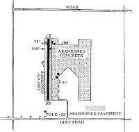
| A32-17/35 | CNTR 75 FT OF 275 FT WIDE CONC SFC; MKD AS RY LEAVING 100 FT WIDE CONC ON EACH SIDE OF RY FULL LENGTH. |
| A33-17/35 | VEGETATION & LOOSE PIECES OF CONC IN JOINTS OF RY. |
| A42-17 | RWY 17 /35 MARKINGS NSTD WIDTH. |
| A42-35 | RWY 17/35 MARKINGS NSTD WIDTH |
| E111 | CONST PRIOR TO 1959. |
Runways
Runway Summary
| Runways: | 17/35 |
| Longest Runway: | 17/35 is 3000 ft (914 m) long |
| Runways with an Instrument Approach: |
30K Airport Runway Details
| Runway 17/35 | 3000 ft x 75 ft (914 m x 23 m) | |
| Surface: | Concrete - Poor condition - No special surface treatment | |
Runway Weight Bearing Capacity (in thousands of pounds) |
||
| Single Wheel Landing Gear: | 21.0 | |
Runway 17 |
Runway 35 |
|
Latitude: |
37-54-39.5681N | 37-54-09.9030N |
Longitude: |
100-31-53.0598W | 100-31-53.1515W |
|
Runway True Alignment: |
180 | 000 |
Glide Path Angle: |
0.0 degrees | 0.0 degrees |
Traffic Pattern: |
Left | Left |
Runway Markings Type: |
Nonstandard (other than numbers only) | Nonstandard (other than numbers only) |
Runway Markings Condition: |
Fair | Fair |
Object at End: |
POLE | |
Object Height: |
22 | |
Distance from End: |
870 | |
Object Centerline Offset: |
170 ft. left of centerline |
Services
Bottled Oxygen: |
None |
Bulk Oxygen: |
None |
Fuel Available: |
100LL |
Landing Fees: |
No |
Parking: |
Hangars and tiedowns available |
Maps & Diagrams
30K Sectional
Flight Planning
at skyvector.com
at skyvector.com