Location
Latitude: |
65-21-16.9900N (65.354719) |
Longitude: |
149-45-40.9600W (-149.761378) |
Elevation: |
1576.0 feet MSL (480 m MSL) |
Magnetic Variation: |
14.9 E (as of April 2024 from WMM2020 model) |
Time Zone: |
UTC -9.0 (Standard Time) UTC -8.0 (Daylight Savings Time) |
From City: |
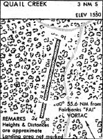
01 N.M. S of Quail Creek, Alaska |
Found On: |
Fairbanks Chart |
FAA Region: |
AAL |
Contacts
Manager: |
Publicly owned: |
| STUART PECHEK AK DEPART OF NATURAL RESOURCES, 3700 AIRPORT WAY FAIRBANKS, AK 99709-4699 907-451-2733 |
AK DEPART OF NATURAL RESOURCES 3700 AIRPORT WAY FAIRBANKS, AK 99709-4699 |
Operations
Airport Status: |
Operational |
Facility Use: |
Public |
Type: |
Airport |
Activation Date: |
01/1966 |
Control tower: |
No |
Attendance (Months/Days/Hours): |
Months/Days/Hours Unattended |
Boundary ARTCC: |
ZAN (Anchorage) |
Responsible ARTCC: |
ZAN (Anchorage) |
Segmented Circle Indicator: |
No |
Traffic Pattern Altitude (MSL): |
2576 feet (785 m) |
NOTAMs Facility: |
FAI |
NOTAM-D Service: |
Yes |
International Airport of Entry: |
No |
Customs Landing Rights: |
No |
Military Landing Rights: |
No |
Civil/Military Joint Use: |
No |
Based Aircraft
Annual Operations (as of 12/31/2019)
| Total Operations: | 80 | |
| Air Taxi: | 50 | 62.5% |
| GA Local: | 30 | 37.5% |
Communications
| CTAF: | 122.900 |
Fixed Based Operators (FBOs) & Fuel
(Click on a business for detail)
Please help us keep this information up to date. This is a FREE SERVICE just like everything else on Airport Guide! If you see that a business needs to be added, modified, or deleted please fill out our Update Form.
To add, modify, or delete a business click here.
Please help us keep this information up to date. This is a FREE SERVICE just like everything else on Airport Guide! If you see that a business needs to be added, modified, or deleted please fill out our Update Form.
Area Code: 907 |
| Business Name | Frequency | Phone | Fuel Grade |
|---|
Flight Service Stations
| Primary | Alternate | |
| FSS on Field: | N | |
| FSS Name (ID): | Fairbanks(FAI) | |
| Frequency: | ||
| Toll Free Phone: | 1-866-248-6516 |
Instrument Procedures / Charts
Terminal Procedures are only available for airports in several countries with more being added all the time. If you are looking for a specific country's charts, please send an email to support(at)airportguide.com stating the country name. This will be used to prioritize the implementation.
Navigation Aids (Navaids) near 20K
| Dist (NM) | ID | Morse Code | Name | Type | Freq | True Hdg | Mag Hdg |
|---|---|---|---|---|---|---|---|
| 49.1 | ENN | . _ . _ . | Nenana | VORTAC | 115.80 | 158 | 143 |
| 51.6 | ICW | . . _ . _ . . _ _ | Ice Pool | NDB | 525 | 159 | 144 |
| 55.3 | FAI | . . _ . . _ . . | Fairbanks | VORTAC | 108.60 | 126 | 111 |
| 59.6 | FOX | . . _ . _ _ _ _ . . _ | Fox | NDB | 356 | 111 | 96 |
| 61.6 | TAL | _ . _ . _ . . | Tanana | VOR-DME | 116.60 | 261 | 247 |
| 62.3 | BCC | _ . . . _ . _ . _ . _ . | Bear Creek | NDB | 212 | 261 | 247 |
| 65.1 | CUN | _ . _ . . . _ _ . | Chena | NDB | 257 | 117 | 102 |
| 79.6 | EIL | . . . . _ . . | Eielson | TACAN | 115.10 | 120 | 105 |
| 90.4 | PPC | . _ _ . . _ _ . _ . _ . | Prospect | NDB | 340 | 346 | 331 |
Nearby Airports with Fuel
| Dist (NM) | Name (Airport IDs) | True Hdg | Mag Hdg | Fuel Grade |
|---|---|---|---|---|
| 51.5 | Nenana Municipal Airport (ENN PANN ENN) |
159 | 144 | 100LL, Jet A |
| 58.0 | Fairbanks International Airport (FAI PAFA FAI) |
123 | 107 | 100LL, Jet A-1 |
| 69.9 | Bradley Sky-Ranch Airport (95Z) |
119 | 103 | 100LL |
Notices to Airmen (NOTAMS)
Remarks
| A110-1 | RY NOT MAINTAINED RECOMMEND VISUAL INSPECTION PRIOR TO LDG. |
| A110-2 | RY 16/34 LOCATED IN MTN RAVINE, EXPECT TURBULENT WINDS. |
| A110-3 | STEEP TURNING APPROACH REQUIRED EITHER DIRECTION. |
| A110-5 | NO LINE OF SIGHT BTN RY ENDS. |
| A110-6 | RY SUITABLE ONLY FOR HIGH-WING, CONVENTIONAL GEARED ACFT, DUE TO BRUSH ENCHROACHMENT. |
| A110-7 | ROAD ALONG THE EAST SIDE OF RUNWAY |
| A30-16/34 | SLOPES DOWN TOWARD NORTH 3%. |
| A33-16/34 | SOFT WHEN WET; TREES UP TO 60 INCH, BRUSH & 36 INCH GRASS ON ENTIRE SFC. |
| A58-16 | NUMEROUS TREES SURROUND RY 16 THLD. |
| A58-34 | TREES AND BRUSH SURROUND RY 34 THLD. |
| A83 | DAMAGED AND UNRELIABLE WIND SOCK ON THE EAST SIDE OF THE APPROACH END OF RUNWAY 02. |
| E111 | ESABD PRIOR TO 1959. |
Runways
Runway Summary
| Runways: | 16/34 |
| Longest Runway: | 16/34 is 1650 ft (503 m) long |
| Runways with an Instrument Approach: |
20K Airport Runway Details
| Runway 16/34 | 1650 ft x 30 ft (503 m x 9 m) | |
| Surface: | Turf/Gravel - Poor condition - No special surface treatment | |
Runway 16 |
Runway 34 |
|
Elevation: |
1564.0 | 1576.0 |
Latitude: |
65-21-25.0000N | 65-21-08.9800N |
Longitude: |
149-45-37.7200W | 149-45-44.2000W |
Glide Path Angle: |
0.0 degrees | 0.0 degrees |
Traffic Pattern: |
Left | Left |
Runway Markings Type: |
None | |
Object at End: |
TREES | TREES |
Object Height: |
63 | 56 |
Distance from End: |
0 | 0 |
Object Centerline Offset: |
55 ft. right of centerline | 0 ft. left and right of centerline |
REIL: |
No | No |
Touchdown Lights: |
No | No |
Centerline Lights: |
No | No |
Services
Airframe Repair: |
None |
Powerplant Repair: |
None |
Bottled Oxygen: |
None |
Bulk Oxygen: |
None |
Fuel Available: |
100LL |
Landing Fees: |
No |
Parking: |
Tiedowns available |
Maps & Diagrams
20K Sectional
Flight Planning
at skyvector.com
at skyvector.com