Location
Latitude: |
40-30-53.7000N (40.514917) |
Longitude: |
098-56-44.3000W (-98.945639) |
Elevation: |
2160.4 feet MSL (658 m MSL) |
Magnetic Variation: |
4.2 E (as of April 2024 from WMM2020 model) |
Time Zone: |
UTC -6.0 (Standard Time) UTC -5.0 (Daylight Savings Time) |
From City: |
01 N.M. NE of Minden, Nebraska |
Found On: |
Omaha Chart |
FAA Region: |
ACE |
Contacts
Manager: |
Publicly owned: |
| BRENT STEWART PO BOX 295 MINDEN, NE 68959-0295 308-830-0391 |
MINDEN AIRPORT AUTHORITY PO BOX 295 MINDEN, NE 68959-0295 308-830-0391 |
Operations
Airport Status: |
Operational |
Facility Use: |
Public |
Type: |
Airport |
Activation Date: |
02/1950 |
Control tower: |
No |
Attendance (Months/Days/Hours): |
Months/Days/Hours Unattended |
Boundary ARTCC: |
ZMP (Minneapolis) |
Responsible ARTCC: |
ZMP (Minneapolis) |
Lighting Schedule: |
SEE RMK |
Segmented Circle Indicator: |
Yes |
Traffic Pattern Altitude (MSL): |
3160 feet (963 m) |
NOTAMs Facility: |
OLU |
NOTAM-D Service: |
Yes |
International Airport of Entry: |
No |
Customs Landing Rights: |
No |
Military Landing Rights: |
Yes |
Civil/Military Joint Use: |
No |
Based Aircraft
| Single Engine: | 13 |
| GA Helicopters: | 1 |
Annual Operations (as of 08/01/2023)
| Total Operations: | 7000 | |
| GA Local: | 4700 | 67.1% |
| GA Itinerant: | 2300 | 32.9% |
Communications
| CTAF: | 122.700 |
| Unicom: | 122.700 |
- APCH/DEP SVC PRVDD BY MINNEAPOLIS ARTCC ON FREQUENCIES 119.4/278.8 (HASTINGS RCAG).
Fixed Based Operators (FBOs) & Fuel
(Click on a business for detail)
Please help us keep this information up to date. This is a FREE SERVICE just like everything else on Airport Guide! If you see that a business needs to be added, modified, or deleted please fill out our Update Form.
To add, modify, or delete a business click here.
Please help us keep this information up to date. This is a FREE SERVICE just like everything else on Airport Guide! If you see that a business needs to be added, modified, or deleted please fill out our Update Form.
Area Code: 308 |
| Business Name | Frequency | Phone | Fuel Grade |
|---|---|---|---|
| Classic Aero
Update FBO info |
Unicom 122.7 | 382-0253 | 100LL, MOGAS |
Flight Service Stations
| Primary | Alternate | |
| FSS on Field: | N | |
| FSS Name (ID): | Columbus(OLU) | |
| Frequency: | ||
| Toll Free Phone: | 1-800-WX-BRIEF |
Instrument Procedures / Charts
FAA Terminal Procedures valid from 0901Z 03/21/24 to 0901Z 04/18/24.
There are various types of charts available for an airport. They are listed in the Page Type column. Here is a legend for those types:
APD - Airport Diagram
DP - Departure Procedure Charts
HOT - Hot Spots
IAP - Instrument Approach Procedure Charts
MIN - Minimums
STAR - Standard Terminal Arrival Charts
| Page Type | Page Name | Volume | Action Since Last Cycle |
|---|---|---|---|
| IAP | RNAV (GPS) RWY 16 | NC-2 | |
| IAP | RNAV (GPS) RWY 34 | NC-2 | |
| MIN | TAKEOFF MINIMUMS | NC-2 |
Terminal Procedures are only available for airports in several countries with more being added all the time. If you are looking for a specific country's charts, please send an email to support(at)airportguide.com stating the country name. This will be used to prioritize the implementation.
Navigation Aids (Navaids) near 0V3
| Dist (NM) | ID | Morse Code | Name | Type | Freq | True Hdg | Mag Hdg |
|---|---|---|---|---|---|---|---|
| 7.6 | EA | . . _ | Anoke | NDB | 422 | 331 | 327 |
| 12.9 | EAR | . . _ . _ . | Kearney | VOR | 111.20 | 347 | 343 |
| 23.7 | PSS | . _ _ . . . . . . . | Prosser | NDB | 338 | 64 | 60 |
| 24.1 | HSI | . . . . . . . . . | Hastings | VOR-DME | 108.80 | 76 | 72 |
| 35.8 | GR | _ _ . . _ . | Sancy | NDB | 380 | 52 | 48 |
| 40.2 | GRI | _ _ . . _ . . . | Grand Island | VOR-DME | 112.00 | 45 | 41 |
| 45.9 | RRX | . _ . . _ . _ . . _ | Darr | NDB | 326 | 295 | 291 |
| 51.0 | PHG | . _ _ . . . . . _ _ . | Phillipsburg | NDB | 368 | 198 | 194 |
| 52.6 | OZB | _ _ _ _ _ . . _ . . . | Cozad | VOR | 109.00 | 294 | 290 |
| 52.9 | TKO | _ _ . _ _ _ _ | Mankato | VORTAC | 109.80 | 143 | 139 |
| 55.6 | DWL | _ . . . _ _ . _ . . | Willow | NDB | 353 | 293 | 288 |
| 56.8 | CSB | _ . _ . . . . _ . . . | Harry Strunk | NDB | 389 | 257 | 252 |
| 58.2 | OBH | _ _ _ _ . . . . . . . | Wolbach | DME | 112 | 27 | 23 |
| 58.7 | NRN | _ . . _ . _ . | Norton | NDB | 230 | 227 | 223 |
| 63.0 | FMZ | . . _ . _ _ _ _ . . | Beklof | NDB | 392 | 85 | 81 |
| 64.6 | JYR | . _ _ _ _ . _ _ . _ . | York | NDB | 257 | 68 | 64 |
| 65.8 | HJH | . . . . . _ _ _ . . . . | Hebron | NDB | 323 | 108 | 104 |
| 66.5 | ODX | _ _ _ _ . . _ . . _ | Ord | NDB | 356 | 359 | 355 |
| 67.2 | CUZ | _ . _ . . . _ _ _ . . | Custer County | VOR-DME | 108.20 | 330 | 326 |
| 72.5 | RPB | . _ . . _ _ . _ . . . | Republican | NDB | 414 | 125 | 121 |
Nearby Airports with Fuel
Notices to Airmen (NOTAMS)
Remarks
| A110-1 | TWR 1163 FT AGL 3240 FT MSL 9 NM ENE. |
| A110-3 | ULTRALIGHT ACTVY ON AND INVOF ARPT. |
| A110-4 | FOR CD CTC MINNEAPOLIS ARTCC AT 651-463-5588. |
| A14 | FOR SVC CTC BRENT 308-830-0391. |
| A52-16 | UNLIGHTED PIVOT IRRIGATION SYSTEM ROTATES THROUGH APPROACH AREA DURING IRRIGATION SEASON. |
| A52-23 | GAS LINE MARKER POLE. |
| A57-05 | RWY 23 UNLGTD PIVOT IRRIGATION SYS ROTS THROUGH APCH AREA DURING IRRIGATION SEASON. PIVOT IS 16 FT ABV; 205 FT OUT, 0B; 12:1 WHEN IN APCH. |
| A81-APT | ACTVT PAPI RWYS 16 & 34; MIRL RWY 16/34 - CTAF. |
Runways
Runway Summary
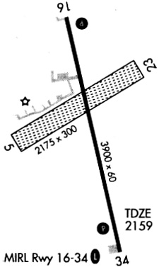
| Runways: | 05/23 16/34 |
| Longest Runway: | 16/34 is 3900 ft (1189 m) long |
| Runways with an Instrument Approach: |
0V3 Airport Runway Details
| Runway 05/23 | 1275 ft x 300 ft (389 m x 91 m) | |
| Runway Length Source: | NACO as of 04/24/2000 | |
| Surface: | Turf - Good condition - No special surface treatment | |
Runway 05 |
Runway 23 |
|
Elevation: |
2154.0 | 2155.0 |
Latitude: |
40-30-55.5650N | 40-31-02.0500N |
Longitude: |
098-56-49.4460W | 098-56-35.2930W |
|
Runway True Alignment: |
059 | 239 |
Glide Path Angle: |
0.0 degrees | 0.0 degrees |
Traffic Pattern: |
Left | Left |
| Runway 16/34 | 3900 ft x 60 ft (1189 m x 18 m) | |
| Runway Length Source: | 3RD PARTY SURVEY as of 08/17/2007 | |
| Surface: | Turf - Good condition - No special surface treatment | |
| Runway Edge Lights: | Medium Intensity | |
Runway Weight Bearing Capacity (in thousands of pounds) |
||
| Single Wheel Landing Gear: | 30.0 | |
| Dual Wheel Landing Gear: | 52.0 | |
Runway 16 |
Runway 34 |
|
Elevation: |
2156.3 | 2152.7 |
Latitude: |
40-31-10.7419N | 40-30-33.2791N |
Longitude: |
098-56-50.9101W | 098-56-39.0662W |
|
Runway True Alignment: |
166 | 346 |
Glide Path Angle: |
3.0 degrees | 3.5 degrees |
Traffic Pattern: |
Left | Right |
Runway Markings Type: |
Nonprecision Instrument | Nonprecision Instrument |
Runway Markings Condition: |
Good | Good |
Object at End: |
FENCE | TREES |
Object Height: |
5 | 44 |
Distance from End: |
340 | 985 |
Visual Glide Slope Indicators: |
2-Light PAPI On Left Side Of Runway | 2-Light PAPI On Left Side Of Runway |
Threshold Crossing Height: |
40 | 40 |
Services
Bottled Oxygen: |
None |
Bulk Oxygen: |
None |
Fuel Available: |
100LL, Jet A+ |
Landing Fees: |
No |
Parking: |
Hangars and tiedowns available |
Maps & Diagrams
0V3 Sectional
Flight Planning
at skyvector.com
at skyvector.com