
Location
Latitude: |
45-28-14.1605N (45.4706) |
Longitude: |
073-44-26.8762W (-73.740799) |
Elevation: |
118 feet MSL (36 m MSL) |
Magnetic Variation: |
13.7 W (as of April 2024 from WMM2020 model) |
Time Zone: |
UTC -5.0 (Standard Time) UTC -4.0 (Daylight Savings Time) |
Contacts
Manager: |
: |
Operations
Airport Status: |
Operational |
Facility Use: |
Public |
Type: |
Airport |
Traffic Pattern Altitude (MSL): |
1118 feet (341 m) |
Based Aircraft
Annual Operations (as of )
Communications
| DAYTON RDO: | 108.4 |
| CTAF: | 126.05 |
| PRINCETON RDO: | 122.55 |
| UNICOM: | 122.95 |
| CTAF/UNICOM: | 122.7 |
| CTAF: | 122.9 |
| LITCHFIELD RDO: | 122.1 |
| CTAF/UNICOM: | 123.075 |
| COLUMBUS RDO: | 122.4 |
| CTAF/UNICOM: | 122.8 |
| WICHITA RDO: | 112.9 |
| CTAF/UNICOM: | 122.8 |
| CTAF/UNICOM: | 122.8 |
| CTAF/UNICOM: | 122.7 |
| CTAF/UNICOM: | 122.7 |
| CTAF/UNICOM: | 122.7 |
| Quebec Radio: | 123.55 |
| Montreal Tower: | 119.9 |
| TWR: | 126.05 |
| CLNC DEL: | 126 |
| CLNC DEL: | 121.3 |
| Montreal Apron: | 122.075 |
| Montreal Ground: | 121.9 |
| GND: | 121.85 |
| POTOMAC APP/DEP: | 119.7 |
| FORT WAYNE APP/DEP: | 132.15 |
| MINNEAPOLIS APP/DEP: | 126.5 |
| DES MOINES APP/DEP: | 123.9 |
| Montreal Terminal Departures: | 118.9 |
| AWOS 3: | 133.85 |
| ATIS: | 120.625 |
| ASOS: | 108.4 |
| French ATIS: | 127.5 |
| English ATIS: | 133.7 |
| AWOS 3: | 120.625 |
| AWOS 3: | 118.325 |
| ASOS: | 132.025 |
| ASOS: | 118.375 |
| DENVER CNTR: | 132.7 |
| TORONTO CNTR: | 132.65 |
| INDIANAPOLIS CNTR: | 128.075 |
| Montreal Terminal Arrivals: | 118.9 |
| Montreal Clearance: | 125.6 |
| Montreal Terminal: | 126.9 |
| Montreal Terminal: | 134.15 |
| KANSAS CITY CNTR: | 118.35 |
| SALT LAKE CITY CNTR: | 128.35 |
Fixed Based Operators (FBOs) & Fuel
(Click on a business for detail)
Please help us keep this information up to date. This is a FREE SERVICE just like everything else on Airport Guide! If you see that a business needs to be added, modified, or deleted please fill out our Update Form.
To add, modify, or delete a business click here.
Please help us keep this information up to date. This is a FREE SERVICE just like everything else on Airport Guide! If you see that a business needs to be added, modified, or deleted please fill out our Update Form.
| Business Name | Frequency | Phone | Fuel Grade |
|---|
Flight Service Stations
| Primary | Alternate | |
| FSS on Field: | ||
| FSS Name (ID): | ||
| Frequency: | ||
| Toll Free Phone: |
Instrument Procedures / Charts
Terminal Procedures are only available for airports in several countries with more being added all the time. If you are looking for a specific country's charts, please send an email to support(at)airportguide.com stating the country name. This will be used to prioritize the implementation.
Navigation Aids (Navaids) near YUL
| Dist (NM) | ID | Morse Code | Name | Type | Freq | True Hdg | Mag Hdg |
|---|---|---|---|---|---|---|---|
| 0.7 | IOA | Montreal Dorval Intl | DME | 110.50 | 168 | 182 | |
| 1.0 | IUL | Montreal | DME | 109.30 | 247 | 261 | |
| 1.7 | ZDV | Valois | NDB | 201 | 234 | 248 | |
| 4.6 | UL | Montreal | NDB | 248 | 262 | 276 | |
| 4.8 | ZUL | Rockland | NDB | 348 | 48 | 62 | |
| 5.6 | ZMT | Jarry | NDB | 284 | 39 | 53 | |
| 13.0 | YUL | _ . _ _ . . _ . _ . . | Montreal | VOR-DME | 116.30 | 312 | 326 |
| 17.3 | ZMR | Hermas | NDB | 272 | 302 | 316 | |
| 17.5 | ZHU | Hauts-Bois | NDB | 407 | 71 | 85 | |
| 17.9 | ZMX | Janvier | NDB | 317 | 335 | 349 | |
| 21.9 | YJN | _ . _ _ . _ _ _ _ . | St Jean | VOR-DME | 115.80 | 125 | 139 |
| 21.9 | YJN | St-Jean | VORTAC | 115.80 | 125 | 139 | |
| 22.5 | ZMM | Joly | NDB | 266 | 304 | 318 | |
| 36.6 | YMX | _ . _ _ _ _ _ . . _ | Mirabel | VOR-DME | 116.70 | 313 | 327 |
| 43.7 | I6R | Bromont | DME | 110.70 | 103 | 117 | |
| 45.3 | UFX | St-Felix-de-Valois | NDB | 260 | 17 | 31 | |
| 48.0 | PLB | . _ _ . . _ . . _ . . . | Plattsburgh | VORTAC | 116.90 | 168 | 182 |
| 53.3 | MSS | _ _ . . . . . . | Massena | TACAN | 114.10 | 231 | 244 |
| 60.0 | BT | _ . . . _ | Herro | NDB | 382 | 159 | 173 |
| 60.6 | Y8 | Drummondville | NDB | 401 | 67 | 81 |
Nearby Airports with Fuel
Notices to Airmen (NOTAMS)
Remarks
No remarks for this landing facility
Runways
Services
Airframe Repair: |
Minor |
Powerplant Repair: |
Minor |
Fuel Available: |
100LL |
Landing Fees: |
No |
Parking: |
Tiedowns available |
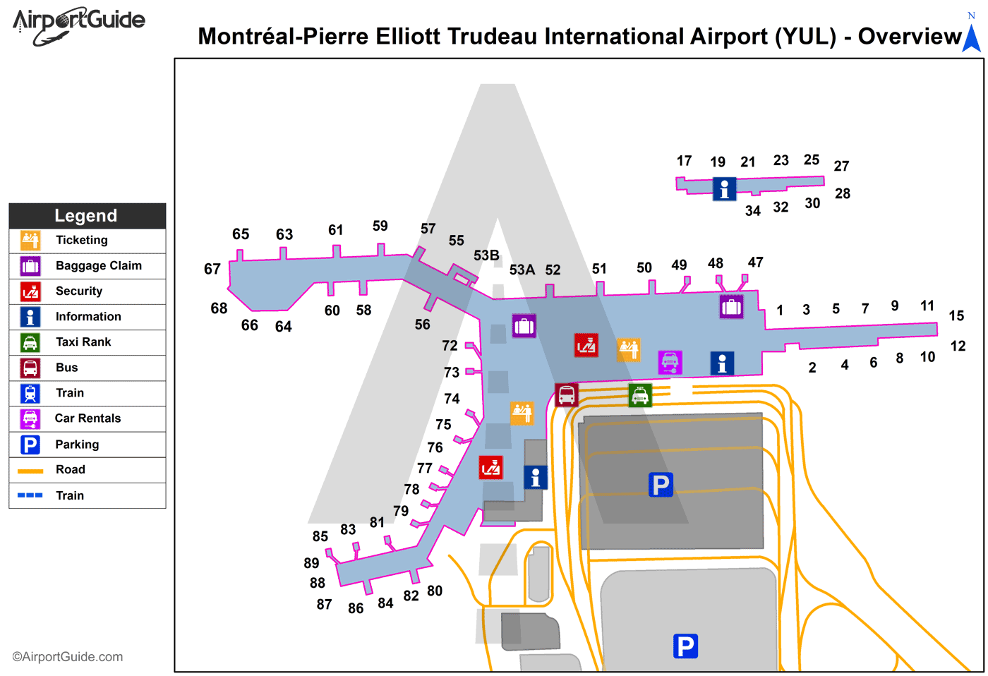
Maps & Diagrams
YUL Sectional
Flight Planning
at skyvector.com
at skyvector.com
