Location
Latitude: |
44-24-55.6530N (44.415459) |
Longitude: |
115-19-00.3760W (-115.316771) |
Elevation: |
6370.0 feet MSL (1942 m MSL) |
Magnetic Variation: |
12.7 E (as of April 2024 from WMM2020 model) |
Time Zone: |
UTC -7.0 (Standard Time) UTC -6.0 (Daylight Savings Time) |
From City: |
20 N.M. NW of Stanley, Idaho |
Found On: |
Salt Lake City Chart |
FAA Region: |
ANM |
Contacts
Manager: |
Publicly owned: |
| AERO DIV ADMIN P O BOX 7129 BOISE, ID 83707-1129 208-334-8775 |
STATE OF ID,ITD,DIV AERO P O BOX 7129 BOISE, ID 83707-1129 208-334-8775 |
Operations
Airport Status: |
Operational |
Facility Use: |
Public |
Type: |
Airport |
Activation Date: |
08/1947 |
Control tower: |
No |
Attendance (Months/Days/Hours): |
Months/Days/Hours Unattended |
Boundary ARTCC: |
ZLC (Salt Lake City) |
Responsible ARTCC: |
ZLC (Salt Lake City) |
Segmented Circle Indicator: |
Yes |
Traffic Pattern Altitude (MSL): |
7370 feet (2246 m) |
NOTAMs Facility: |
BOI |
NOTAM-D Service: |
Yes |
Military Landing Rights: |
No |
Civil/Military Joint Use: |
No |
Based Aircraft
Annual Operations (as of 07/30/2022)
| Total Operations: | 2100 | |
| Air Taxi: | 1200 | 57.1% |
| GA Itinerant: | 900 | 42.9% |
Communications
| CTAF: | 122.900 |
Fixed Based Operators (FBOs) & Fuel
(Click on a business for detail)
Please help us keep this information up to date. This is a FREE SERVICE just like everything else on Airport Guide! If you see that a business needs to be added, modified, or deleted please fill out our Update Form.
To add, modify, or delete a business click here.
Please help us keep this information up to date. This is a FREE SERVICE just like everything else on Airport Guide! If you see that a business needs to be added, modified, or deleted please fill out our Update Form.
Area Code: 208 |
| Business Name | Frequency | Phone | Fuel Grade |
|---|
Flight Service Stations
| Primary | Alternate | |
| FSS on Field: | N | |
| FSS Name (ID): | Boise(BOI) | |
| Frequency: | ||
| Toll Free Phone: | 1-800-WX-BRIEF |
Instrument Procedures / Charts
Terminal Procedures are only available for airports in several countries with more being added all the time. If you are looking for a specific country's charts, please send an email to support(at)airportguide.com stating the country name. This will be used to prioritize the implementation.
Navigation Aids (Navaids) near U63
| Dist (NM) | ID | Morse Code | Name | Type | Freq | True Hdg | Mag Hdg |
|---|---|---|---|---|---|---|---|
| 43.5 | DNJ | _ . . _ . . _ _ _ | Donnelly | VOR-DME | 116.20 | 299 | 286 |
| 63.9 | LKT | . _ . . _ . _ _ | Salmon | VOR-DME | 113.50 | 54 | 41 |
| 64.1 | BOI | _ . . . _ _ _ . . | Boise | VORTAC | 113.30 | 216 | 203 |
| 64.6 | BOI | _ . . . _ _ _ . . | Boise | VOT | 116.70 | 217 | 204 |
| 65.3 | BO | _ . . . _ _ _ | Ustik | NDB | 359 | 221 | 208 |
| 71.8 | MPA | _ _ . _ _ . . _ | Meridian | NDB | 238 | 227 | 214 |
| 76.5 | ONO | _ _ _ _ . _ _ _ | Ontario | NDB | 305 | 252 | 239 |
| 79.5 | STI | . . . _ . . | Sturgeon | NDB | 333 | 190 | 177 |
| 80.0 | HLE | . . . . . _ . . . | Hailey | NDB-DME | 220 | 144 | 132 |
| 86.0 | MUO | _ _ . . _ _ _ _ | Mountain Home | TACAN | 114.00 | 196 | 183 |
| 88.2 | LIA | . _ . . . . . _ | Liberator | VOR | 114.90 | 193 | 180 |
| 94.2 | HDG | . . . . _ . . _ _ . | Steelhead | NDB | 211 | 162 | 150 |
Nearby Airports with Fuel
Notices to Airmen (NOTAMS)
Remarks
| A110-1 | NO WINTER MAINTENANCE. |
| A110-2 | ARPT IS LCTD ON A HIGH MTN VALLEY SURROUNDED BY MTNS. |
| A110-4 | BIG GAME ANIMALS HAVE ACCESS TO RY. |
| A110-5 | RY 23 FENCE MARKED WITH YELLOW AND BLACK WARNING PANELS 40 FT FM AER 23. |
| A110-6 | FOR CD CTC SALT LAKE ARTCC AT 801-320-2568. |
| A30-05/23 | RECOMMEND LAND RWY 05; TKOF RWY 23 WHEN WND CONDITIONS PERMIT. |
| A33-05/23 | FIRST 1200 FT OF RWY END 05 IS FLOODED OR VERY SOFT DRG SPRING AND THRU LATE SUMMER MONTHS. |
| A33-05/23 1 | 20 FT WIDE DIRT STRIP DOWN CENTER OF RY 05/23. |
| A42-05 | 05/23 EDGES AND THRS MKD WITH WHITE ROCKS. |
| A52-23 | RY 23 5 FT FENCE AT 40 FT ON CNTRLN; 200 FT TIMBERED RIDGE AT 2000 FT ON CNTRLN; 13 FT RD AT 300 FT ON CNTRLN; 20 FT POLE AT 300 FT ON CNTRLN; 20 FT POLE AT 400 FT, 50 FT LEFT. |
| A84 | ONE-HALF SEGMENTED CIRCLE. |
| E111 | EXISTED PRIOR TO 1959. |
Runways
Runway Summary
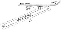
| Runways: | 05/23 |
| Longest Runway: | 05/23 is 5000 ft (1524 m) long |
| Runways with an Instrument Approach: |
U63 Airport Runway Details
| Runway 05/23 | 5000 ft x 110 ft (1524 m x 34 m) | |
| Surface: | Turf/Dirt - Fair condition - No special surface treatment | |
Runway 05 |
Runway 23 |
|
Glide Path Angle: |
0.0 degrees | 0.0 degrees |
Traffic Pattern: |
Left | Left |
Object at End: |
FENCE | |
Object Height: |
0 | 5 |
Distance from End: |
0 | 0 |
Object Centerline Offset: |
0 ft. left and right of centerline | 70 ft. right of centerline |
Services
Airframe Repair: |
None |
Powerplant Repair: |
None |
Bottled Oxygen: |
None |
Bulk Oxygen: |
None |
Fuel Available: |
Mogas |
Landing Fees: |
No |
Parking: |
Tiedowns available |
Maps & Diagrams
U63 Sectional
Flight Planning
at skyvector.com
at skyvector.com