Location
Latitude: |
32-21-12.7700N (32.353547) |
Longitude: |
095-24-10.7200W (-95.402978) |
Elevation: |
543.9 feet MSL (166 m MSL) |
Magnetic Variation: |
1.8 E (as of April 2024 from WMM2020 model) |
Time Zone: |
UTC -6.0 (Standard Time) UTC -5.0 (Daylight Savings Time) |
From City: |
03 N.M. W of Tyler, Texas |
Found On: |
Dallas-Ft Worth Chart |
FAA Region: |
ASW |
Contacts
Manager: |
Publicly owned: |
| STEVE M. THOMPSON 700 SKYWAY BLVD, SUITE 201 TYLER, TX 75704 903-531-2343 |
CITY OF TYLER PO BOX 2039 TYLER, TX 75710 903-531-9825 |
Operations
Airport Status: |
Operational |
Facility Use: |
Public |
Type: |
Airport |
Activation Date: |
11/1937 |
Control tower: |
Yes |
Attendance (Months/Days/Hours): |
Months/Days/Hours ALL/ALL/0500-2200 |
Boundary ARTCC: |
ZFW (Fort Worth) |
Responsible ARTCC: |
ZFW (Fort Worth) |
Lighting Schedule: |
SEE RMK |
Segmented Circle Indicator: |
Yes |
Traffic Pattern Altitude (MSL): |
1544 feet (471 m) |
NOTAMs Facility: |
TYR |
NOTAM-D Service: |
Yes |
International Airport of Entry: |
No |
Customs Landing Rights: |
No |
Military Landing Rights: |
Yes |
Civil/Military Joint Use: |
No |
Aircraft Rescue and Firefighting: |
Class I ARFF Index: B Air Carrier Service: Scheduled Certification Date: 05/1973 |
Based Aircraft
| Single Engine: | 71 |
| Multi Engine: | 15 |
| Jet Engine: | 19 |
| GA Helicopters: | 5 |
Annual Operations (as of 04/30/2023)
| Total Operations: | 38562 | |
| Commercial: | 1788 | 4.6% |
| Air Taxi: | 3582 | 9.3% |
| GA Local: | 9613 | 24.9% |
| GA Itinerant: | 22432 | 58.2% |
| Military Aircraft: | 1147 | 3.0% |
Communications
| CTAF: | 120.100 |
| Unicom: | 122.950 |
| Tower: | POUNDS 120.1 257.8 Hrs: 0630-2130 |
| Ground: | 121.9 |
| Approach: | LONGVIEW 128.75 128.75 FORT WORTH ARTCC |
| Departure: | LONGVIEW 128.75 128.75 FORT WORTH ARTCC |
| ATIS: | 126.25 Hrs: 24 |
| ASOS: | (903-535-9105) |
| EMERG: | 121.5 |
| EMERG: | 243.0 |
- APCH/DEP CTL SVC PRVDD BY FORT WORTH ARTCC (ZFW) ON FREQS 135.25/265.1 (FRANKSTON RCAG) WHEN LONGVIEW APCH CTL CLSD.
Fixed Based Operators (FBOs) & Fuel
(Click on a business for detail)
Please help us keep this information up to date. This is a FREE SERVICE just like everything else on Airport Guide! If you see that a business needs to be added, modified, or deleted please fill out our Update Form.
To add, modify, or delete a business click here.
Please help us keep this information up to date. This is a FREE SERVICE just like everything else on Airport Guide! If you see that a business needs to be added, modified, or deleted please fill out our Update Form.
Area Code: 903 |
| Business Name | Frequency | Phone | Fuel Grade |
|---|---|---|---|
| Johson Aviation
Update FBO info |
Unicom 118.0 | 593-4343 | 100LL, Jet A |
| Tyler Aero of Texas
Update FBO info |
Unicom 123.5 | 595-4255 | 100LL, Jet A |
| Tyler International Aviation School
Update FBO info |
592-1291 | 100LL | |
| Tyler Jet Aviation
Update FBO info |
Unicom 122.95, Arinc 130.675 | 595-2000 | |
| Wilkinson Aircraft Services
Update FBO info |
592-3651 |
Flight Service Stations
| Primary | Alternate | |
| FSS on Field: | N | |
| FSS Name (ID): | Fort Worth(FTW) | |
| Frequency: | ||
| Toll Free Phone: | 1-800-WX-BRIEF |
Instrument Procedures / Charts
FAA Terminal Procedures valid from 0901Z 03/21/24 to 0901Z 04/18/24.
There are various types of charts available for an airport. They are listed in the Page Type column. Here is a legend for those types:
APD - Airport Diagram
DP - Departure Procedure Charts
HOT - Hot Spots
IAP - Instrument Approach Procedure Charts
MIN - Minimums
STAR - Standard Terminal Arrival Charts
| Page Type | Page Name | Volume | Action Since Last Cycle |
|---|---|---|---|
| APD | AIRPORT DIAGRAM | SC-2 | |
| HOT | HOT SPOT | SC-2 | |
| IAP | ILS OR LOC RWY 04 | SC-2 | |
| IAP | RNAV (GPS) RWY 04 | SC-2 | |
| IAP | RNAV (GPS) RWY 13 | SC-2 | |
| IAP | RNAV (GPS) RWY 18 | SC-2 | |
| IAP | RNAV (GPS) RWY 22 | SC-2 | |
| IAP | RNAV (GPS) RWY 31 | SC-2 | |
| IAP | RNAV (GPS) RWY 36 | SC-2 | |
| IAP | VOR RWY 04 | SC-2 | |
| IAP | VOR RWY 31 | SC-2 | |
| MIN | ALTERNATE MINIMUMS | SC-2 | |
| MIN | TAKEOFF MINIMUMS | SC-2 |
Terminal Procedures are only available for airports in several countries with more being added all the time. If you are looking for a specific country's charts, please send an email to support(at)airportguide.com stating the country name. This will be used to prioritize the implementation.
Navigation Aids (Navaids) near TYR
| Dist (NM) | ID | Morse Code | Name | Type | Freq | True Hdg | Mag Hdg |
|---|---|---|---|---|---|---|---|
| 0.1 | TYR | _ _ . _ _ . _ . | Tyler | VOR-DME | 114.20 | 349 | 347 |
| 5.0 | TY | _ _ . _ _ | Indoo | NDB | 320 | 317 | 315 |
| 18.0 | FZT | . . _ . _ _ . . _ | Frankston | VOR-DME | 111.40 | 201 | 199 |
| 20.2 | ABG | . _ _ . . . _ _ . | Ambassador | NDB | 404 | 46 | 44 |
| 24.6 | AHX | . _ . . . . _ . . _ | Athens | NDB | 269 | 241 | 239 |
| 29.2 | HNO | . . . . _ . _ _ _ | Henderson | NDB | 371 | 109 | 107 |
| 30.5 | JSO | . _ _ _ . . . _ _ _ | Cherokee County | NDB | 263 | 161 | 159 |
| 31.3 | GG | _ _ . _ _ . | Veels | NDB | 410 | 78 | 76 |
| 31.7 | UIM | . . _ . . _ _ | Quitman | DME | 114 | 3 | 1 |
| 33.1 | CSZ | _ . _ . . . . _ _ . . | Crossroads | NDB | 215 | 238 | 236 |
| 33.1 | GGG | _ _ . _ _ . _ _ . | Gregg County | VORTAC | 112.90 | 83 | 81 |
| 37.6 | PSN | . _ _ . . . . _ . | Palestine | NDB | 375 | 203 | 201 |
| 42.6 | CQY | _ . _ . _ _ . _ _ . _ _ | Cedar Creek | VORTAC | 114.80 | 256 | 254 |
| 49.3 | AVZ | . _ . . . _ _ _ . . | Travis | NDB | 260 | 299 | 297 |
| 50.0 | PYF | . _ _ . _ . _ _ . . _ . | Pyramid | NDB | 418 | 234 | 232 |
| 50.5 | SYW | . . . _ . _ _ . _ _ | Cash | NDB | 428 | 318 | 316 |
| 51.2 | SLR | . . . . _ . . . _ . | Sulphur Springs | DME | 109 | 352 | 350 |
| 54.0 | CRS | _ . _ . . _ . . . . | Corsicana | NDB | 396 | 249 | 247 |
| 54.2 | MJF | _ _ . _ _ _ . . _ . | Arvilla | TACAN | 109.60 | 322 | 320 |
| 54.8 | CGQ | _ . _ . _ _ . _ _ . _ | Powell | NDB | 344 | 251 | 249 |
Nearby Airports with Fuel
Notices to Airmen (NOTAMS)
Remarks
| A110-3 | HELICOPTERS OPERATING INBOUND OR OUTBOUND TO/FROM THE DOWNTOWN HOSPITALS STATE INTENTION ON 123.075. |
| A110-6 | WEST SIDE PSGR TERMINAL RAMP ACCESS RSTD TO ACR. |
| A110-7 | NOISE ABATEMENT PROCEDURES IN EFFECT CALL 903-590-3048. |
| A110-8 | CONDS NOT MNTD BTN THE HRS OF 9:30 PM AND 6:30 AM LOCAL. |
| A110-9 | FOR CD IF UNA TO CTC ON FSS FREQ, CTC FORT WORTH ARTCC AT 817-858-7584. |
| A43-22 | UNUSBL BYD 9 DEG LEFT AND RIGHT OF RWY CNTRLN. |
| A81-APT | WHEN ATCT CLSD ACTVT MALSR RWY 04; REIL RWY 22; HIRL RWY 04/22; MIRL RWY 18/36; TWY LGTS - CTAF. HIRL RWY 13/31 PRESET MED INTST, TO INCR INTST ACTVT - CTAF. PAPI RWYS 04 & 22, VASI RWY 31 OPR CONSLY. |
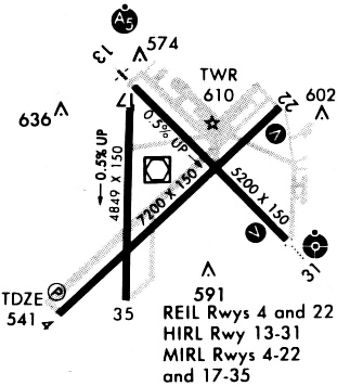
Runways
Runway Summary
| Runways: | 04/22 13/31 18/36 |
| Longest Runway: | 04/22 is 8334 ft (2540 m) long |
| Runways with an Instrument Approach: | 04 |
TYR Airport Runway Details
| Runway 04/22 | 8334 ft x 150 ft (2540 m x 46 m) | |
| Runway Length Source: | 3RD PARTY SURVEY as of 08/24/2020 | |
| Surface: | Concrete - Excellent condition - Saw-cut or plastic grooved | |
| Runway Pavement Class: | 68 /R/C/W/T | |
| Runway Edge Lights: | High Intensity | |
Runway Weight Bearing Capacity (in thousands of pounds) |
||
| Single Wheel Landing Gear: | 120.0 | |
| Dual Wheel Landing Gear: | 222.0 | |
| Dual Tandem Wheel Landing Gear: | 357.0 | |
Runway 04 |
Runway 22 |
|
Elevation: |
540.3 | 529.5 |
Latitude: |
32-20-37.4867N | 32-21-35.6776N |
Longitude: |
095-24-47.8383W | 095-23-39.0090W |
|
Runway True Alignment: |
045 | 225 |
ILS Type: |
ILS/DME | |
Glide Path Angle: |
3.0 degrees | 3.0 degrees |
Traffic Pattern: |
Left | Left |
Runway Markings Type: |
Precision Instrument | Precision Instrument |
Runway Markings Condition: |
Good | Good |
Object at End: |
TREE | |
Object Height: |
28 | |
Distance from End: |
1146 | |
Object Centerline Offset: |
80 ft. right of centerline | |
Visual Glide Slope Indicators: |
4-Light PAPI On Left Side Of Runway | 4-Light PAPI On Left Side Of Runway |
Approach Light System: |
1,400 Foot Medium Intensity Approach Lighting System With Runway Alignment Indicator Lights | |
REIL: |
No | Yes |
Threshold Crossing Height: |
55 | 54 |
Threshold Elevation: |
531.9 | |
Displaced Threshold: |
600 | |
Threshold Latitude: |
32-21-31.4865N | |
Threshold Longitude: |
095-23-43.9655W | |
Declared Distances |
||
Take Off Run Avbl. (TORA): |
8334 | 8334 |
Take Off Distance Avbl. (TODA): |
8334 | 8334 |
Actual Stop Dist. Avbl. (ASDA): |
7734 | 8334 |
Landing Dist. Avbl. (LDA): |
7734 | 7734 |
| Runway 13/31 | 5198 ft x 150 ft (1584 m x 46 m) | |
| Runway Length Source: | 3RD PARTY SURVEY as of 08/24/2020 | |
| Surface: | Concrete - Excellent condition - Saw-cut or plastic grooved | |
| Runway Pavement Class: | 9 /F/C/X/T | |
| Runway Edge Lights: | High Intensity | |
Runway Weight Bearing Capacity (in thousands of pounds) |
||
| Single Wheel Landing Gear: | 25.0 | |
| Dual Wheel Landing Gear: | 40.0 | |
Runway 13 |
Runway 31 |
|
Elevation: |
515.4 | 542.3 |
Latitude: |
32-21-40.3641N | 32-21-03.9006N |
Longitude: |
095-24-19.4691W | 095-23-36.7306W |
|
Runway True Alignment: |
135 | 315 |
Glide Path Angle: |
0.0 degrees | 3.0 degrees |
Traffic Pattern: |
Left | Left |
Runway Markings Type: |
Precision Instrument | Precision Instrument |
Runway Markings Condition: |
Good | Good |
Object at End: |
POLE | ROAD |
Object Height: |
28 | 14 |
Distance from End: |
1550 | 600 |
Object Centerline Offset: |
80 ft. right of centerline | |
Visual Glide Slope Indicators: |
4-Box VASI On Left Side Of Runway | |
Threshold Crossing Height: |
54 | |
Declared Distances |
||
Take Off Run Avbl. (TORA): |
5198 | 5198 |
Take Off Distance Avbl. (TODA): |
5198 | 5198 |
Actual Stop Dist. Avbl. (ASDA): |
5198 | 5198 |
Landing Dist. Avbl. (LDA): |
5198 | 5198 |
| Runway 18/36 | 4832 ft x 150 ft (1473 m x 46 m) | |
| Runway Length Source: | 3RD PARTY SURVEY as of 08/24/2020 | |
| Surface: | Concrete - Excellent condition - Saw-cut or plastic grooved | |
| Runway Pavement Class: | 43 /F/B/X/T | |
| Runway Edge Lights: | Medium Intensity | |
Runway Weight Bearing Capacity (in thousands of pounds) |
||
| Single Wheel Landing Gear: | 109.0 | |
| Dual Wheel Landing Gear: | 172.0 | |
| Dual Tandem Wheel Landing Gear: | 289.0 | |
Runway 18 |
Runway 36 |
|
Elevation: |
517.0 | 543.6 |
Latitude: |
32-21-37.2732N | 32-20-49.4619N |
Longitude: |
095-24-19.5533W | 095-24-19.7054W |
|
Runway True Alignment: |
180 | 000 |
Glide Path Angle: |
0.0 degrees | 0.0 degrees |
Traffic Pattern: |
Left | Left |
Runway Markings Type: |
Nonprecision Instrument | Nonprecision Instrument |
Runway Markings Condition: |
Good | Good |
Object at End: |
TREE | TREE |
Object Height: |
38 | 43 |
Distance from End: |
1100 | 1158 |
Object Centerline Offset: |
80 ft. right of centerline | |
Declared Distances |
||
Take Off Run Avbl. (TORA): |
4832 | 4832 |
Take Off Distance Avbl. (TODA): |
4832 | 4832 |
Actual Stop Dist. Avbl. (ASDA): |
4832 | 4832 |
Landing Dist. Avbl. (LDA): |
4832 | 4832 |
Services
Airframe Repair: |
Minor |
Powerplant Repair: |
Major |
Bottled Oxygen: |
None |
Bulk Oxygen: |
None |
Fuel Available: |
100LL, Jet A+ |
Landing Fees: |
No |
Parking: |
Tiedowns available |
Maps & Diagrams
TYR Sectional
Flight Planning
at skyvector.com
at skyvector.com