Location
Latitude: |
39-29-56.8000N (39.499111) |
Longitude: |
119-46-05.2000W (-119.768111) |
Elevation: |
4414.9 feet MSL (1346 m MSL) |
Magnetic Variation: |
12.9 E (as of April 2024 from WMM2020 model) |
Time Zone: |
UTC -8.0 (Standard Time) UTC -7.0 (Daylight Savings Time) |
From City: |
03 N.M. SE of Reno, Nevada |
Found On: |
San Francisco Chart |
FAA Region: |
AWP |
Contacts
Manager: |
Publicly owned: |
| DAREN GRIFFIN, A.A.E. P O BOX 12490 RENO, NV 89510-2490 775-328-6550 |
RENO-TAHOE AIRPORT AUTHORITY P O BOX 12490 RENO, NV 89510-2490 775-328-6402 |
Operations
Airport Status: |
Operational |
Facility Use: |
Public |
Type: |
Airport |
Activation Date: |
11/1938 |
Control tower: |
Yes |
Attendance (Months/Days/Hours): |
Months/Days/Hours ALL/ALL/ALL |
Boundary ARTCC: |
ZOA (Oakland) |
Responsible ARTCC: |
ZOA (Oakland) |
Segmented Circle Indicator: |
No |
Traffic Pattern Altitude (MSL): |
5415 feet (1650 m) |
NOTAMs Facility: |
RNO |
NOTAM-D Service: |
Yes |
International Airport of Entry: |
No |
Customs Landing Rights: |
Yes |
Military Landing Rights: |
Yes |
Civil/Military Joint Use: |
No |
Aircraft Rescue and Firefighting: |
Class I ARFF Index: C Air Carrier Service: Scheduled Certification Date: 05/1973 |
Based Aircraft
| Single Engine: | 114 |
| Multi Engine: | 18 |
| Jet Engine: | 25 |
| GA Helicopters: | 3 |
| Military Aircraft: | 9 |
Annual Operations (as of 06/30/2022)
| Total Operations: | 107096 | |
| Commercial: | 44896 | 41.9% |
| Air Taxi: | 18079 | 16.9% |
| GA Local: | 5217 | 4.9% |
| GA Itinerant: | 36556 | 34.1% |
| Military Aircraft: | 2348 | 2.2% |
Communications
| Unicom: | 122.950 |
| Tower: | RENO 118.7 257.8 Hrs: 24 |
| Clearance Del.: | 124.9 370.85 |
| Ground: | 121.9 348.6 |
| Approach: | NORCAL |
| Departure: | NORCAL |
| ATIS: | 135.8 363.0 Hrs: 24 |
| ASOS: | 135.8 (775-324-6659) |
| EMERG: | 121.5 |
| ANG COMD POST: | 378.4 ;CALLSIGN-ROLLER OPS. |
| ANG OPS: | 378.4 ;CALLSIGN-ROLLER OPS. |
| ANG COMD POST: | 8780 ;CALLSIGN-ROLLER OPS. |
| EMERG: | 243.0 |
| ANG OPS: | 8780 ;CALLSIGN-ROLLER OPS. |
| ANG OPS: | 280.0 |
Fixed Based Operators (FBOs) & Fuel
(Click on a business for detail)
Please help us keep this information up to date. This is a FREE SERVICE just like everything else on Airport Guide! If you see that a business needs to be added, modified, or deleted please fill out our Update Form.
To add, modify, or delete a business click here.
Please help us keep this information up to date. This is a FREE SERVICE just like everything else on Airport Guide! If you see that a business needs to be added, modified, or deleted please fill out our Update Form.
Area Code: 775 |
| Business Name | Frequency | Phone | Fuel Grade |
|---|---|---|---|
| Airtronics
Update FBO info |
828-4300 | ||
| Jet West
Update FBO info |
Unicom 122.95 | 825-6400 | 100LL, Jet A |
| Mercury Air Center
Update FBO info |
Unicom 122.95, Arinc 131.6 | 858-7300 | 100LL, Jet A |
| Premier Aviation
Update FBO info |
856-2355 | ||
| Reno Flying Service, Inc.
Update FBO info |
Unicom 122.95 | 856-5800 | |
| Sierra Air Center
Update FBO info |
Unicom 122.95 | 856-8900 | 100LL, Jet A |
| The Hangar
Update FBO info |
323-8111 |
Flight Service Stations
| Primary | Alternate | |
| FSS on Field: | N | |
| FSS Name (ID): | Reno(RNO) | |
| Frequency: | ||
| Toll Free Phone: | 1-800-WX-BRIEF |
Instrument Procedures / Charts
FAA Terminal Procedures valid from 0901Z 03/21/24 to 0901Z 04/18/24.
There are various types of charts available for an airport. They are listed in the Page Type column. Here is a legend for those types:
APD - Airport Diagram
DP - Departure Procedure Charts
HOT - Hot Spots
IAP - Instrument Approach Procedure Charts
MIN - Minimums
STAR - Standard Terminal Arrival Charts
Terminal Procedures are only available for airports in several countries with more being added all the time. If you are looking for a specific country's charts, please send an email to support(at)airportguide.com stating the country name. This will be used to prioritize the implementation.
Navigation Aids (Navaids) near RNO
| Dist (NM) | ID | Morse Code | Name | Type | Freq | True Hdg | Mag Hdg |
|---|---|---|---|---|---|---|---|
| 5.5 | FMG | . . _ . _ _ _ _ . | Mustang | VORTAC | 117.90 | 69 | 56 |
| 30.1 | SWR | . . . . _ _ . _ . | Squaw Valley | VOR-DME | 113.20 | 230 | 217 |
| 35.7 | HZN | . . . . _ _ . . _ . | Hazen | VORTAC | 114.10 | 88 | 75 |
| 49.4 | AHC | . _ . . . . _ . _ . | Amedee | VOR-DME | 109.00 | 339 | 326 |
| 49.5 | NFL | _ . . . _ . . _ . . | Fallon | TACAN | 113.50 | 95 | 82 |
| 65.2 | HNW | . . . . _ . . _ _ | Hangtown | VOR-DME | 115.50 | 224 | 211 |
| 66.5 | LLC | . _ . . . _ . . _ . _ . | Lovelock | VORTAC | 116.50 | 55 | 42 |
| 80.7 | BAB | _ . . . . _ _ . . . | Beale | TACAN | 108.60 | 254 | 241 |
| 87.2 | MYV | _ _ _ . _ _ . . . _ | Marysville | VOR-DME | 110.80 | 254 | 241 |
| 87.7 | MY | _ _ _ . _ _ | Halow | NDB | 222 | 257 | 244 |
| 91.1 | MCC | _ _ _ . _ . _ . _ . | Mc Clellan | VOR-DME | 109.20 | 237 | 224 |
| 97.6 | CIC | _ . _ . . . _ . _ . | Chico | VOR-DME | 109.80 | 280 | 267 |
| 97.8 | SMF | . . . _ _ . . _ . | Sacramento Intl | VOT | 111.40 | 240 | 227 |
| 98.4 | MVA | _ _ . . . _ . _ | Mina | VORTAC | 115.10 | 124 | 111 |
Nearby Airports with Fuel
Notices to Airmen (NOTAMS)
Remarks
| A110-1 | WATERFOWL ALL QUADRANTS ALL SEASONS. CONCENTRATED NW OF RWY 17R AND EAST OF RWY 17L. |
| A110-10 | GLIDER/SOARING OPER 30-50 MILES SOUTH OF ARPT DURING VFR WEATHER & MOUNTAIN WAVE WIND CONDITIONS 1100 TO SS. |
| A110-15 | TWY C BTN TWY L AND TWY D CLSD TO AIR CARRIER ACFT. |
| A110-16 | TWY A BETWEEN NORTH TWY B AND TWY D CLSD TO ACFT WITH WINGSPAN GREATER THAN 149 FT. |
| A110-17 | ALL COMMERCIAL AIRCRAFT CONTACT GROUND CONTROL FOR ADVISORIES PRIOR TO PUSH BACK ON THE TERMINAL RAMP. |
| A110-19 | INTENSIVE GLIDER ACTIVITY INVOF ARPT AND SURROUNDING AREAS UP TO 18000 FT. |
| A110-2 | 24 HRS PPR FOR TSNT ACFT PARKING WITH WINGSPANS GREATER THAN 75 FT. |
| A110-20 | ANG: PPR 24 HR PN RQRD. |
| A110-21 | TWY M CLSD TO AIR CARRIER ACFT. |
| A110-22 | TWY J EAST OF RY 16L/34R CLSD TO AIR CARRIER ACFT. |
| A110-23 | ANG: ANG OPS 1430-2359Z++ MON-FRI EXC HOL AND SKED DAYS OFF; OTR TIMES BY NOTAM; DSN 830-4709 OR C775-788-4709. |
| A110-24 | ANG: APN HAS 22 FT X 6 FT ACFT GND EQUIP (AGE) BOXES LCTD TO THE EAST OF EA PKG SPOT. |
| A110-25 | PRESIDENT / CEO OF RENO-TAHOE ARPT AUTHORITY-DARREN GRIFFIN, CARRIE GUEDEA, AMGR (775) 328-6446. |
| A110-26 | ACFT OVR 12500 LBS: WRITTEN PPR FOR TRNG FLIGHTS; FOR MORE INFO CTC ARPT OPS 1-775-328-6490. |
| A110-27 | ANG: COMSEC MTRL STORAGE AVBL WITH PRIOR CDN AT 152 CF/SCXS, DSN 830-4798. |
| A110-3 | TWY C BTN TWY L & TWY D RSTRD TO ACFT 100000 LBS OR LESS. |
| A110-4 | NOISE SENSITIVE AREA ALL QUADS. PILOTS OF TBJT ACFT USE RCMDD NOISE ABATEMENT PROCS; AVBL ON REQ. |
| A110-5 | NOISE NOTE CONT: PILOTS OF NON-TBJT ACFT USE BEST ABATEMENT PROCS AND SETTINGS. AVOID AS MUCH AS FEASIBLE FLYING OVER POPULATED AREAS. |
| A110-6 | MIL ACFT: TSNT ACFT EXECUTE STRAIGHT-IN FULL STOP APCH. OVERHEAD PAT NOT AUTH FOR TSNT ACFT. |
| A110-7 | MIL ACFT: NOISE ABTMT CRITICAL TERMINATE AFTERBURNER ASAP THEN CLIMB TO 6500 FT MSL ASAP. |
| A57-35L | APCH RATIO 37:1 TO DTHR. |
| E147 | 800 FT AGL SNGL ENG; 1000 FT AGL MULT ENG/TURBOPROP/JET. |
| E80 | LDG RIGHTS ARPT, PPR - CALL (775) 784-5585; AFT HRS LDG WO PRIOR APVL NA. |
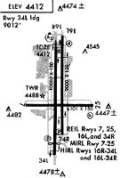
Runways
Runway Summary
| Runways: | 08/26 17L/35R 17R/35L |
| Longest Runway: | 17R/35L is 11001 ft (3353 m) long |
| Runways with an Instrument Approach: | 17R, 35L |
RNO Airport Runway Details
| Runway 08/26 | 6102 ft x 150 ft (1860 m x 46 m) | |
| Runway Length Source: | 3RD PARTY SURVEY as of 10/08/2014 | |
| Surface: | Concrete - Good condition - Saw-cut or plastic grooved | |
| Runway Pavement Class: | 72 /R/B/W/T | |
| Runway Edge Lights: | Medium Intensity | |
Runway Weight Bearing Capacity (in thousands of pounds) |
||
| Single Wheel Landing Gear: | 60.0 | |
| Dual Wheel Landing Gear: | 170.0 | |
| Dual Tandem Wheel Landing Gear: | 260.0 | |
Runway 08 |
Runway 26 |
|
Elevation: |
4409.2 | 4399.6 |
Latitude: |
39-29-46.6299N | 39-29-46.3739N |
Longitude: |
119-46-43.8220W | 119-45-25.9978W |
|
Runway True Alignment: |
090 | 270 |
Glide Path Angle: |
3.2 degrees | 3.0 degrees |
Traffic Pattern: |
Left | Left |
Runway Markings Type: |
Nonprecision Instrument | Nonprecision Instrument |
Runway Markings Condition: |
Good | Good |
Object at End: |
POLE | TREE |
Object Height: |
118 | 44 |
Distance from End: |
2625 | 1150 |
Object Centerline Offset: |
500 ft. left of centerline | 275 ft. left of centerline |
Visual Glide Slope Indicators: |
4-Light PAPI On Left Side Of Runway | 4-Light PAPI On Left Side Of Runway |
REIL: |
Yes | Yes |
Touchdown Lights: |
No | No |
Centerline Lights: |
No | No |
Threshold Crossing Height: |
48 | 45 |
Declared Distances |
||
Take Off Run Avbl. (TORA): |
5854 | 6102 |
Take Off Distance Avbl. (TODA): |
5854 | 6102 |
Actual Stop Dist. Avbl. (ASDA): |
6102 | 6102 |
Landing Dist. Avbl. (LDA): |
5854 | 6102 |
| Runway 17L/35R | 9000 ft x 150 ft (2743 m x 46 m) | |
| Runway Length Source: | 3RD PARTY SURVEY as of 10/08/2014 | |
| Surface: | Concrete - Good condition - Saw-cut or plastic grooved | |
| Runway Pavement Class: | 88 /R/B/W/T | |
| Runway Edge Lights: | High Intensity | |
Runway Weight Bearing Capacity (in thousands of pounds) |
||
| Single Wheel Landing Gear: | 75.0 | |
| Dual Wheel Landing Gear: | 209.0 | |
| Dual Tandem Wheel Landing Gear: | 407.0 | |
| Dual Dual Tandem Wheel Landing Gear: | 850.0 | |
Runway 17L |
Runway 35R |
|
Elevation: |
4414.8 | 4408.3 |
Latitude: |
39-30-49.8258N | 39-29-20.8949N |
Longitude: |
119-46-00.2660W | 119-46-00.4971W |
|
Runway True Alignment: |
180 | 000 |
Glide Path Angle: |
3.0 degrees | 3.4 degrees |
Runway Markings Type: |
Nonprecision Instrument | Nonprecision Instrument |
Runway Markings Condition: |
Good | Good |
Object Centerline Offset: |
500 ft. left of centerline | 275 ft. left of centerline |
Visual Glide Slope Indicators: |
4-Light PAPI On Left Side Of Runway | 4-Light PAPI On Left Side Of Runway |
REIL: |
Yes | Yes |
Centerline Lights: |
Yes | Yes |
Threshold Crossing Height: |
75 | 75 |
Declared Distances |
||
Take Off Run Avbl. (TORA): |
9000 | 9000 |
Take Off Distance Avbl. (TODA): |
9000 | 9000 |
Actual Stop Dist. Avbl. (ASDA): |
9000 | 9000 |
Landing Dist. Avbl. (LDA): |
9000 | 9000 |
| Runway 17R/35L | 11001 ft x 150 ft (3353 m x 46 m) | |
| Runway Length Source: | 3RD PARTY SURVEY as of 10/08/2014 | |
| Surface: | Concrete - Good condition - Saw-cut or plastic grooved | |
| Runway Pavement Class: | 88 /R/B/W/T | |
| Runway Edge Lights: | High Intensity | |
Runway Weight Bearing Capacity (in thousands of pounds) |
||
| Single Wheel Landing Gear: | 75.0 | |
| Dual Wheel Landing Gear: | 185.0 | |
| Dual Tandem Wheel Landing Gear: | 350.0 | |
| Dual Dual Tandem Wheel Landing Gear: | 850.0 | |
Runway 17R |
Runway 35L |
|
Elevation: |
4414.8 | 4414.5 |
Latitude: |
39-30-49.8381N | 39-29-01.1337N |
Longitude: |
119-46-09.1937W | 119-46-09.4750W |
|
Runway True Alignment: |
180 | 000 |
ILS Type: |
ILS/DME | ILS/DME |
Glide Path Angle: |
3.1 degrees | 3.5 degrees |
Traffic Pattern: |
Left | Left |
Runway Markings Type: |
Precision Instrument | Precision Instrument |
Runway Markings Condition: |
Good | Good |
Object at End: |
GND | |
Object Height: |
243 | |
Distance from End: |
8050 | |
Object Centerline Offset: |
500 ft. left of centerline | 275 ft. left of centerline |
Visual Glide Slope Indicators: |
4-Light PAPI On Left Side Of Runway | 4-Light PAPI On Left Side Of Runway |
Runway Visual Range (RVR): |
Touchdown | Rollout |
Approach Light System: |
1,400 Foot Medium Intensity Approach Lighting System With Runway Alignment Indicator Lights | 1,400 Foot Medium Intensity Approach Lighting System With Runway Alignment Indicator Lights |
REIL: |
No | No |
Touchdown Lights: |
No | No |
Centerline Lights: |
Yes | Yes |
Threshold Crossing Height: |
77 | 72 |
Threshold Elevation: |
4414.8 | 4410.2 |
Displaced Threshold: |
1000 | 990 |
Threshold Latitude: |
39-30-39.9618N | 39-29-10.9129N |
Threshold Longitude: |
119-46-09.2208W | 119-46-09.4465W |
Declared Distances |
||
Take Off Run Avbl. (TORA): |
11001 | 11001 |
Take Off Distance Avbl. (TODA): |
11001 | 11001 |
Actual Stop Dist. Avbl. (ASDA): |
11001 | 11001 |
Landing Dist. Avbl. (LDA): |
10001 | 10011 |
Services
Airframe Repair: |
Major |
Powerplant Repair: |
Major |
Bottled Oxygen: |
None |
Bulk Oxygen: |
None |
Fuel Available: |
100LL, Jet A |
Landing Fees: |
No |
Parking: |
Tiedowns available |
Maps & Diagrams
RNO Sectional
Flight Planning
at skyvector.com
at skyvector.com