Location
Latitude: |
46-41-20.2700N (46.688964) |
Longitude: |
068-02-41.2490W (-68.044791) |
Elevation: |
534.0 feet MSL (163 m MSL) |
Magnetic Variation: |
16.1 W (as of April 2024 from WMM2020 model) |
Time Zone: |
UTC -5.0 (Standard Time) UTC -4.0 (Daylight Savings Time) |
From City: |
01 N.M. NW of Presque Isle, Maine |
Found On: |
Halifax Chart |
FAA Region: |
ANE |
Contacts
Manager: |
Publicly owned: |
| SCOTT WARDWELL 650 AIRPORT DR SUITE 11 PRESQUE ISLE, ME 04769 207-764-2550 |
CITY OF PRESQUE ISLE 12 SECOND ST PRESQUE ISLE, ME 04769 207-764-4485 |
Operations
Airport Status: |
Operational |
Facility Use: |
Public |
Type: |
Airport |
Activation Date: |
04/1940 |
Control tower: |
No |
Attendance (Months/Days/Hours): |
Months/Days/Hours ALL/ALL/0600-1900 |
Boundary ARTCC: |
ZBW (Boston) |
Responsible ARTCC: |
ZBW (Boston) |
Lighting Schedule: |
SEE RMK |
Segmented Circle Indicator: |
Yes |
Traffic Pattern Altitude (MSL): |
1534 feet (468 m) |
NOTAMs Facility: |
PQI |
NOTAM-D Service: |
Yes |
International Airport of Entry: |
No |
Customs Landing Rights: |
Yes |
Military Landing Rights: |
Yes |
Civil/Military Joint Use: |
No |
Aircraft Rescue and Firefighting: |
Class I ARFF Index: A Air Carrier Service: Scheduled Certification Date: 05/1973 |
Based Aircraft
| Single Engine: | 17 |
| Multi Engine: | 2 |
| Jet Engine: | 2 |
Annual Operations (as of 07/31/2023)
| Total Operations: | 8404 | |
| Commercial: | 1222 | 14.5% |
| Air Taxi: | 4210 | 50.1% |
| GA Local: | 920 | 10.9% |
| GA Itinerant: | 1999 | 23.8% |
| Military Aircraft: | 53 | 0.6% |
Communications
| CTAF: | 122.800 |
| Unicom: | 122.800 |
| AWOS-3PT: | 118.025 (207-764-7248) |
- APCH/DEP SVC PRVDD BY BOSTON ARTCC ON FREQS 124.75/239.05 (CARIBOU RCAG).
- CLNC DEL PRVDD BY BOSTON ARTCC ON FREQ 121.6.
Fixed Based Operators (FBOs) & Fuel
(Click on a business for detail)
Please help us keep this information up to date. This is a FREE SERVICE just like everything else on Airport Guide! If you see that a business needs to be added, modified, or deleted please fill out our Update Form.
To add, modify, or delete a business click here.
Please help us keep this information up to date. This is a FREE SERVICE just like everything else on Airport Guide! If you see that a business needs to be added, modified, or deleted please fill out our Update Form.
Area Code: 207 |
| Business Name | Frequency | Phone | Fuel Grade |
|---|---|---|---|
| General Aviation
Update FBO info |
Unicom 122.8 | 764-2555 | 100LL, Jet A |
Flight Service Stations
| Primary | Alternate | |
| FSS on Field: | N | |
| FSS Name (ID): | Bangor(BGR) | |
| Frequency: | ||
| Toll Free Phone: | 1-800-WX-BRIEF |
Instrument Procedures / Charts
FAA Terminal Procedures valid from 0901Z 03/21/24 to 0901Z 04/18/24.
There are various types of charts available for an airport. They are listed in the Page Type column. Here is a legend for those types:
APD - Airport Diagram
DP - Departure Procedure Charts
HOT - Hot Spots
IAP - Instrument Approach Procedure Charts
MIN - Minimums
STAR - Standard Terminal Arrival Charts
| Page Type | Page Name | Volume | Action Since Last Cycle |
|---|---|---|---|
| IAP | ILS OR LOC RWY 01 | NE-1 | |
| IAP | RNAV (GPS) RWY 01 | NE-1 | |
| IAP | RNAV (GPS) RWY 19 | NE-1 | |
| IAP | RNAV (GPS) RWY 28 | NE-1 | |
| IAP | VOR RWY 19 | NE-1 | |
| MIN | ALTERNATE MINIMUMS | NE-1 | |
| MIN | TAKEOFF MINIMUMS | NE-1 |
Terminal Procedures are only available for airports in several countries with more being added all the time. If you are looking for a specific country's charts, please send an email to support(at)airportguide.com stating the country name. This will be used to prioritize the implementation.
Navigation Aids (Navaids) near PQI
| Dist (NM) | ID | Morse Code | Name | Type | Freq | True Hdg | Mag Hdg |
|---|---|---|---|---|---|---|---|
| 4.8 | PQ | . _ _ . _ _ . _ | Excal | NDB | 278 | 167 | 183 |
| 5.5 | PQI | . _ _ . _ _ . _ . . | Presque Isle | VOR-DME | 116.40 | 338 | 354 |
| 39.9 | HUL | . . . . . . _ . _ . . | Houlton | DME | 116.1 | 167 | 183 |
| 65.9 | LNT | . _ . . _ . _ | Milnot | NDB | 344 | 198 | 214 |
| 69.0 | MLT | _ _ . _ . . _ | Millinocket | VOR-DME | 117.90 | 196 | 212 |
| 75.7 | FC | Fredericton | NDB | 326 | 127 | 143 | |
| 79.4 | IDC | Fredericton | DME | 111.30 | 128 | 144 | |
| 82.5 | YFC | _ . _ _ . . _ . _ . _ . | Fredericton | VORTAC | 113.00 | 124 | 140 |
| 82.8 | PNN | . _ _ . _ . _ . | Princeton | DME | 114.3 | 170 | 186 |
| 89.8 | RI | Riviere Du Loup | NDB | 201 | 316 | 332 | |
| 89.9 | YRI | Riviere Du Loup | VOR | 113.90 | 316 | 332 |
Nearby Airports with Fuel
| Dist (NM) | Name (Airport IDs) | True Hdg | Mag Hdg | Fuel Grade |
|---|---|---|---|---|
| 11.0 | Caribou Municipal Airport (CAR KCAR CAR) |
5 | 21 | 100LL |
| 31.2 | Long Lake Seaplane Base (92B) |
345 | 361 | MOGAS |
| 35.4 | Houlton International Airport (HUL KHUL HUL) |
162 | 178 | 100LL, Jet A, Jet A+ |
| 37.4 | Northern Aroostook Regional Airport (WFK KFVE FVE) |
343 | 359 | 100LL, Jet A |
| 41.7 | Shin Pond Seaplane Base (85B) |
211 | 227 | 100LL |
| 66.5 | Millinocket Seaplane Base (70B) |
210 | 226 | 100LL |
| 67.9 | Millinocket Municipal Airport (MLT KMLT MLT) |
203 | 219 | 100LL, Jet A |
| 96.7 | Greenville Municipal Airport (3B1) |
220 | 235 | 100LL, Jet A |
| 97.6 | Moosehead Aero Marine Seaplane Base (52B) |
222 | 237 | 100LL |
Notices to Airmen (NOTAMS)
Remarks
| A110-2 | PAEW ADJ TO RWYS & TWYS (MOWING) MAY 1 THRU NOV 1. |
| A110-4 | FOR CD CTC BOSTON ARTCC AT 603-879-6859. |
| A110-5 | CTN SML UAS ACT FM SFC TO 400 FT AGL (1040-MSL) 3.5 NM S OF ARPT DUR DALGT HRS. |
| A26 | CLSD TO UNSKED ACR OPS WITH MORE THAN 30 PAX SEATS, EXCP PPR CALL AMGR 207-764-2550. |
| A45-19 | PAPI VISUAL GA NON-STD. |
| A81-APT | ACTVT MALSR RWY 01; REIL RWY 19; PAPI RWY 19 & 28; HIRL RWY 01/19; MIRL RWY 10/28 - 122.6. |
| E111 | EXISTED PRIOR TO 1959. |
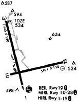
Runways
Runway Summary
| Runways: | 01/19 10/28 |
| Longest Runway: | 01/19 is 7441 ft (2268 m) long |
| Runways with an Instrument Approach: | 01 |
PQI Seaplane Base Runway Details
| Runway 01/19 | 7441 ft x 150 ft (2268 m x 46 m) | |
| Runway Length Source: | 3RD PARTY SURVEY as of 11/20/2018 | |
| Surface: | Asphalt - Good condition - No special surface treatment | |
| Runway Pavement Class: | 94 /F/A/W/T | |
| Runway Edge Lights: | High Intensity | |
Runway Weight Bearing Capacity (in thousands of pounds) |
||
| Single Wheel Landing Gear: | 100.0 | |
| Dual Wheel Landing Gear: | 150.0 | |
| Dual Tandem Wheel Landing Gear: | 240.0 | |
Runway 01 |
Runway 19 |
|
Elevation: |
455.0 | 534.0 |
Latitude: |
46-40-52.3584N | 46-42-03.5166N |
Longitude: |
068-02-44.0943W | 068-03-10.4791W |
|
Runway True Alignment: |
346 | 166 |
ILS Type: |
ILS | |
Glide Path Angle: |
0.0 degrees | 3.7 degrees |
Traffic Pattern: |
Left | Left |
Runway Markings Type: |
Precision Instrument | Precision Instrument |
Runway Markings Condition: |
Good | Good |
Object at End: |
TREES | |
Object Height: |
115 | |
Distance from End: |
2500 | |
Object Centerline Offset: |
0 ft. left and right of centerline | 425 ft. left of centerline |
Visual Glide Slope Indicators: |
4-Light PAPI On Left Side Of Runway | |
Approach Light System: |
1,400 Foot Medium Intensity Approach Lighting System With Runway Alignment Indicator Lights | |
REIL: |
No | Yes |
Touchdown Lights: |
No | No |
Centerline Lights: |
No | No |
Threshold Crossing Height: |
50 | |
Declared Distances |
||
Take Off Run Avbl. (TORA): |
7441 | 7441 |
Take Off Distance Avbl. (TODA): |
7441 | 7441 |
Actual Stop Dist. Avbl. (ASDA): |
7441 | 7441 |
Landing Dist. Avbl. (LDA): |
7441 | 7441 |
| Runway 10/28 | 6000 ft x 100 ft (1829 m x 30 m) | |
| Runway Length Source: | 3RD PARTY SURVEY as of 11/20/2018 | |
| Surface: | Asphalt - Good condition - No special surface treatment | |
| Runway Pavement Class: | 94 /F/A/W/T | |
| Runway Edge Lights: | Medium Intensity | |
Runway Weight Bearing Capacity (in thousands of pounds) |
||
| Single Wheel Landing Gear: | 100.0 | |
| Dual Wheel Landing Gear: | 150.0 | |
| Dual Tandem Wheel Landing Gear: | 240.0 | |
Runway 10 |
Runway 28 |
|
Elevation: |
473.2 | 473.2 |
Latitude: |
46-41-03.4395N | 46-41-18.0788N |
Longitude: |
068-03-03.0583W | 068-01-39.6717W |
|
Runway True Alignment: |
076 | 256 |
Glide Path Angle: |
0.0 degrees | 3.0 degrees |
Traffic Pattern: |
Left | Left |
Runway Markings Type: |
Nonprecision Instrument | Nonprecision Instrument |
Runway Markings Condition: |
Good | Good |
Object at End: |
TREE | RR |
Object Height: |
44 | 31 |
Distance from End: |
1300 | 1200 |
Object Centerline Offset: |
0 ft. left and right of centerline | 425 ft. left of centerline |
Visual Glide Slope Indicators: |
4-Light PAPI On Left Side Of Runway | |
REIL: |
No | No |
Touchdown Lights: |
No | No |
Centerline Lights: |
No | No |
Threshold Crossing Height: |
45 | |
Declared Distances |
||
Take Off Run Avbl. (TORA): |
6000 | 6000 |
Take Off Distance Avbl. (TODA): |
6000 | 6000 |
Actual Stop Dist. Avbl. (ASDA): |
6000 | 6000 |
Landing Dist. Avbl. (LDA): |
6000 | 6000 |
Services
Bottled Oxygen: |
None |
Bulk Oxygen: |
None |
Fuel Available: |
100LL |
Maps & Diagrams
PQI Sectional
Flight Planning
at skyvector.com
at skyvector.com