Location
Latitude: |
35-53-40.0100N (35.894447) |
Longitude: |
090-09-16.4540W (-90.154571) |
Elevation: |
242.7 feet MSL (74 m MSL) |
Magnetic Variation: |
1.8 W (as of April 2024 from WMM2020 model) |
Time Zone: |
UTC -6.0 (Standard Time) UTC -5.0 (Daylight Savings Time) |
From City: |
02 N.M. NE of Manila, Arkansas |
Found On: |
Memphis Chart |
FAA Region: |
ASW |
Contacts
Manager: |
Publicly owned: |
| JOHN GEARHART PO BOX 895 MANILA, AR 72442 479-757-0722 |
CITY OF MANILA PO BOX 895 MANILA, AR 72442 870-561-4437 |
Operations
Airport Status: |
Operational |
Facility Use: |
Public |
Type: |
Airport |
Activation Date: |
04/1944 |
Control tower: |
No |
Attendance (Months/Days/Hours): |
Months/Days/Hours ALL/ALL/DALGT |
Boundary ARTCC: |
ZME (Memphis) |
Responsible ARTCC: |
ZME (Memphis) |
Lighting Schedule: |
SEE RMK |
Segmented Circle Indicator: |
Yes |
Traffic Pattern Altitude (MSL): |
1243 feet (379 m) |
NOTAMs Facility: |
JBR |
NOTAM-D Service: |
Yes |
International Airport of Entry: |
No |
Customs Landing Rights: |
No |
Military Landing Rights: |
Yes |
Civil/Military Joint Use: |
No |
Based Aircraft
| Single Engine: | 20 |
| Multi Engine: | 3 |
Annual Operations (as of 03/31/2019)
| Total Operations: | 31100 | |
| GA Local: | 30000 | 96.5% |
| GA Itinerant: | 1000 | 3.2% |
| Military Aircraft: | 100 | 0.3% |
Communications
| CTAF: | 122.800 |
| Unicom: | 122.800 |
- APCH/DEP SVC PRVDD BY MEMPHIS ARTCC ON FREQS 120.075/289.4 (WALNUT RIDGE RCAG).
Fixed Based Operators (FBOs) & Fuel
(Click on a business for detail)
Please help us keep this information up to date. This is a FREE SERVICE just like everything else on Airport Guide! If you see that a business needs to be added, modified, or deleted please fill out our Update Form.
To add, modify, or delete a business click here.
Please help us keep this information up to date. This is a FREE SERVICE just like everything else on Airport Guide! If you see that a business needs to be added, modified, or deleted please fill out our Update Form.
Area Code: 870 |
| Business Name | Frequency | Phone | Fuel Grade |
|---|---|---|---|
| Sentinel Aviation LLC
Update FBO info |
122.800 | 479-757-0722 | 100LL |

|
Unknown | 100LL - 3.99 USD per gallon on 2/10/2019 |
Pumps requiring line service |
Flight Service Stations
| Primary | Alternate | |
| FSS on Field: | N | |
| FSS Name (ID): | Jonesboro(JBR) | |
| Frequency: | ||
| Toll Free Phone: | 1-800-WX-BRIEF |
Instrument Procedures / Charts
FAA Terminal Procedures valid from 0901Z 03/21/24 to 0901Z 04/18/24.
There are various types of charts available for an airport. They are listed in the Page Type column. Here is a legend for those types:
APD - Airport Diagram
DP - Departure Procedure Charts
HOT - Hot Spots
IAP - Instrument Approach Procedure Charts
MIN - Minimums
STAR - Standard Terminal Arrival Charts
| Page Type | Page Name | Volume | Action Since Last Cycle |
|---|---|---|---|
| IAP | RNAV (GPS) RWY 18 | SC-1 | |
| IAP | RNAV (GPS) RWY 36 | SC-1 | |
| MIN | TAKEOFF MINIMUMS | SC-1 |
Terminal Procedures are only available for airports in several countries with more being added all the time. If you are looking for a specific country's charts, please send an email to support(at)airportguide.com stating the country name. This will be used to prioritize the implementation.
Navigation Aids (Navaids) near MXA
| Dist (NM) | ID | Morse Code | Name | Type | Freq | True Hdg | Mag Hdg |
|---|---|---|---|---|---|---|---|
| 10.9 | GOJ | _ _ . _ _ _ . _ _ _ | Gosnell | VOR | 111.80 | 71 | 73 |
| 21.1 | JBR | . _ _ _ _ . . . . _ . | Jonesboro | VOR-DME | 115.85 | 266 | 268 |
| 33.1 | COO | _ . _ . _ _ _ _ _ _ | Covington | NDB | 326 | 123 | 125 |
| 36.4 | GQE | _ _ . _ _ . _ . | Gilmore | VOR-DME | 113.00 | 205 | 207 |
| 38.4 | MIG | _ _ . . _ _ . | Millington | NDB | 232 | 163 | 165 |
| 40.9 | ARG | . _ . _ . _ _ . | Walnut Ridge | VORTAC | 114.50 | 288 | 290 |
| 41.3 | DYR | _ . . _ . _ _ . _ . | Dyersburg | TACAN | 116.80 | 79 | 81 |
| 41.3 | MAW | _ _ . _ . _ _ | Malden | TACAN | 111.20 | 16 | 18 |
| 41.7 | TNZ | _ _ . _ _ . . | Lawrence County | NDB | 227 | 296 | 298 |
| 41.9 | SPQ | . . . . _ _ . _ _ . _ | Spain | NDB | 414 | 173 | 175 |
| 47.2 | FD | . . _ . _ . . | Earli | NDB | 278 | 349 | 351 |
| 50.1 | ME | _ _ . | Elvis | NDB | 287 | 175 | 177 |
| 51.4 | MEM | _ _ . _ _ | Memphis Metropolitn | VOT | 111.00 | 170 | 172 |
| 53.4 | MEM | _ _ . _ _ | Memphis | VORTAC | 117.50 | 170 | 172 |
| 55.6 | FYE | . . _ . _ . _ _ . | Somerville | NDB | 255 | 137 | 139 |
| 61.2 | UC | . . _ _ . _ . | Obion | NDB | 212 | 66 | 68 |
| 62.6 | MKL | _ _ _ . _ . _ . . | Mersy | NDB | 394 | 110 | 112 |
| 63.0 | MKL | _ _ _ . _ . _ . . | Mc Kellar | VOR-DME | 112.00 | 105 | 107 |
| 68.8 | CHQ | _ . _ . . . . . _ _ . _ | Charleston | NDB | 208 | 33 | 35 |
| 74.8 | HLI | . . . . . _ . . . . | Holly Springs | VORTAC | 112.40 | 154 | 156 |
Nearby Airports with Fuel
Notices to Airmen (NOTAMS)
Remarks
| A110-1 | NUMEROUS AGRICULTURAL ACFT OPNS FM FEB-NOV 500 FT AGL & BLO. |
| A110-2 | FOR CD CTC MEMPHIS ARTCC AT 901-368-8453/8449. |
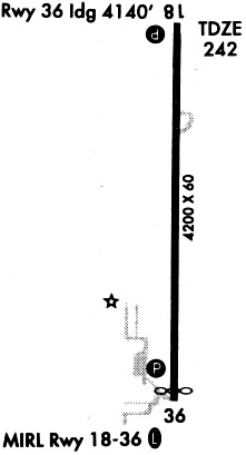
| A57-36 | APCH SLOPE 34:1 TO DSPLCD THLD. |
| A70-FUEL-10 | 0LL FOR SVC AFT HRS CALL 901-605-1094 OUR 479-757-0722 NO FEE. FUEL AVBL WITH CREDIT CARD 8AM TO 5PM. |
| A81-APT | ACTVT REIL RWYS 18 & 36; MIRL RWY 18/36; AND PAPI RWYS 18 & 36 - CTAF. LOCAL ARPT WX 4 CLICKS |
| A82 | 4 CLICKS FOR TEMP, WIND, AND DENSITY ALT. |
Runways
Runway Summary
| Runways: | 18/36 |
| Longest Runway: | 18/36 is 4201 ft (1280 m) long |
| Runways with an Instrument Approach: |
MXA Airport Runway Details
| Runway 18/36 | 4201 ft x 75 ft (1280 m x 23 m) | |
| Runway Length Source: | 3RD PARTY SURVEY as of 06/29/2019 | |
| Surface: | Asphalt - Good condition - No special surface treatment | |
| Runway Edge Lights: | Medium Intensity | |
Runway Weight Bearing Capacity (in thousands of pounds) |
||
| Single Wheel Landing Gear: | 15.0 | |
Runway 18 |
Runway 36 |
|
Elevation: |
240.8 | 242.7 |
Latitude: |
35-54-00.7828N | 35-53-19.2365N |
Longitude: |
090-09-16.3292W | 090-09-16.5784W |
|
Runway True Alignment: |
180 | 000 |
Glide Path Angle: |
4.0 degrees | 4.0 degrees |
Traffic Pattern: |
Left | Right |
Runway Markings Type: |
Nonprecision Instrument | Nonprecision Instrument |
Runway Markings Condition: |
Good | Good |
Object at End: |
TREE | ROAD |
Object Height: |
75 | 14 |
Distance from End: |
2300 | 495 |
Object Centerline Offset: |
0 ft. left and right of centerline | 0 ft. left and right of centerline |
Visual Glide Slope Indicators: |
2-Light PAPI On Right Side Of Runway | 2-Light PAPI On Left Side Of Runway |
REIL: |
Yes | Yes |
Threshold Crossing Height: |
48 | 28 |
Threshold Elevation: |
242.6 | |
Displaced Threshold: |
60 | |
Threshold Latitude: |
35-53-19.8303N | |
Threshold Longitude: |
090-09-16.5807W |
Services
Airframe Repair: |
Minor |
Powerplant Repair: |
Minor |
Bottled Oxygen: |
None |
Bulk Oxygen: |
None |
Fuel Available: |
100LL, Jet A |
Landing Fees: |
No |
Parking: |
Tiedowns available |
Maps & Diagrams
MXA Sectional
Flight Planning
at skyvector.com
at skyvector.com