Location
Latitude: |
31-34-56.9000N (31.582472) |
Longitude: |
102-54-32.5000W (-102.909028) |
Elevation: |
2614.5 feet MSL (797 m MSL) |
Magnetic Variation: |
5.9 E (as of April 2024 from WMM2020 model) |
Time Zone: |
UTC -6.0 (Standard Time) UTC -5.0 (Daylight Savings Time) |
From City: |
01 N.M. SW of Monahans, Texas |
Found On: |
San Antonio Chart |
FAA Region: |
ASW |
Contacts
Manager: |
Publicly owned: |
| JOHN CUTBIRTH P.O.BOX 1610 MONAHANS, TX 79756 432-940-2633 |
CITY OF MONAHANS 112 WEST 2ND ST MONAHANS, TX 79756 432-940-2633 |
Operations
Airport Status: |
Operational |
Facility Use: |
Public |
Type: |
Airport |
Activation Date: |
05/1946 |
Control tower: |
No |
Attendance (Months/Days/Hours): |
Months/Days/Hours ALL/ALL/0700-1700 |
Boundary ARTCC: |
ZFW (Fort Worth) |
Responsible ARTCC: |
ZFW (Fort Worth) |
Lighting Schedule: |
SEE RMK |
Segmented Circle Indicator: |
Yes |
Traffic Pattern Altitude (MSL): |
3614 feet (1102 m) |
NOTAMs Facility: |
SJT |
NOTAM-D Service: |
Yes |
International Airport of Entry: |
No |
Customs Landing Rights: |
No |
Military Landing Rights: |
Yes |
Civil/Military Joint Use: |
No |
Based Aircraft
| Single Engine: | 21 |
| Multi Engine: | 1 |
| Jet Engine: | 1 |
| GA Helicopters: | 2 |
Annual Operations (as of 05/20/2021)
| Total Operations: | 7500 | |
| GA Local: | 5000 | 66.7% |
| GA Itinerant: | 2500 | 33.3% |
Communications
| CTAF: | 122.800 |
| Unicom: | 122.800 |
- APCH/DEP CTL SVC PRVDD BY FORT WORTH ARTCC (ZFW) ON FREQS 133.1/298.95 (MIDLAND/A RCAG).
Fixed Based Operators (FBOs) & Fuel
(Click on a business for detail)
Please help us keep this information up to date. This is a FREE SERVICE just like everything else on Airport Guide! If you see that a business needs to be added, modified, or deleted please fill out our Update Form.
To add, modify, or delete a business click here.
Please help us keep this information up to date. This is a FREE SERVICE just like everything else on Airport Guide! If you see that a business needs to be added, modified, or deleted please fill out our Update Form.
Area Code: 915 |
| Business Name | Frequency | Phone | Fuel Grade |
|---|---|---|---|
| West Winds Aviation
Update FBO info |
Unicom 122.8 | 943-9527 | 100LL, Jet A |
Flight Service Stations
| Primary | Alternate | |
| FSS on Field: | N | |
| FSS Name (ID): | San Angelo(SJT) | |
| Frequency: | ||
| Toll Free Phone: | 1-800-WX-BRIEF |
Instrument Procedures / Charts
FAA Terminal Procedures valid from 0901Z 03/21/24 to 0901Z 04/18/24.
There are various types of charts available for an airport. They are listed in the Page Type column. Here is a legend for those types:
APD - Airport Diagram
DP - Departure Procedure Charts
HOT - Hot Spots
IAP - Instrument Approach Procedure Charts
MIN - Minimums
STAR - Standard Terminal Arrival Charts
| Page Type | Page Name | Volume | Action Since Last Cycle |
|---|---|---|---|
| IAP | RNAV (GPS) RWY 12 | SC-3 | |
| IAP | RNAV (GPS) RWY 30 | SC-3 | |
| IAP | VOR/DME RWY 12 | SC-3 | |
| MIN | TAKEOFF MINIMUMS | SC-3 |
Terminal Procedures are only available for airports in several countries with more being added all the time. If you are looking for a specific country's charts, please send an email to support(at)airportguide.com stating the country name. This will be used to prioritize the implementation.
Navigation Aids (Navaids) near MIF
| Dist (NM) | ID | Morse Code | Name | Type | Freq | True Hdg | Mag Hdg |
|---|---|---|---|---|---|---|---|
| 24.5 | INK | . . _ . _ . _ | Wink | VORTAC | 112.10 | 315 | 309 |
| 34.7 | PEQ | . _ _ . . _ _ . _ | Pecos | VOR-DME | 116.50 | 258 | 252 |
| 38.0 | FST | . . _ . . . . _ | Fort Stockton | VORTAC | 116.90 | 185 | 179 |
| 38.5 | MA | _ _ . _ | Farly | NDB | 326 | 50 | 44 |
| 42.0 | MAF | _ _ . _ . . _ . | Midland | VOT | 108.20 | 59 | 53 |
| 44.7 | MAF | _ _ . _ . . _ . | Midland | VORTAC | 114.80 | 54 | 48 |
| 65.9 | HOB | . . . . _ _ _ _ . . . | Hobbs | VORTAC | 111.00 | 343 | 337 |
| 66.7 | GNC | _ _ . _ . _ . _ . | Gaines County | NDB | 344 | 11 | 5 |
| 74.8 | XAA | _ . . _ . _ . _ | Kent | NDB | 225 | 243 | 237 |
| 77.4 | BWR | _ . . . . _ _ . _ . | Brewster County | NDB | 412 | 209 | 203 |
| 78.3 | CNM | _ . _ . _ . _ _ | Carlsbad | VORTAC | 116.30 | 301 | 295 |
| 80.9 | IMP | . . _ _ . _ _ . | Marathon | NDB | 388 | 192 | 186 |
| 83.6 | CV | _ . _ . . . . _ | Carlz | NDB | 402 | 299 | 293 |
| 86.7 | LSA | . _ . . . . . . _ | Lamesa | NDB | 338 | 35 | 29 |
| 87.1 | BGS | _ . . . _ _ . . . . | Big Spring | VORTAC | 117.20 | 56 | 50 |
| 94.0 | MRF | _ _ . _ . . . _ . | Marfa | VOR-DME | 115.90 | 215 | 209 |
Nearby Airports with Fuel
Notices to Airmen (NOTAMS)
Remarks
| A110*G | THIS AIRPORT HAS BEEN SURVEYED BY THE NATIONAL GEODETIC SURVEY. |
| A110-1 | DOWN SLOPE OFF END OF RWY 30. |
| A110-2 | WILDLIFE & BIRDS ON & INVOF ARPT. |
| A110-4 | FOR CD CTC FORT WORTH ARTCC AT 817-858-7584. |
| A110-5 | RWY 19 APCH- 325 FT AGL. 2953 MSL ANTENNA, 1.45 NM NE OF ARPT. |
| A81-APT | ACTVT PAPI RWY 12; MIRL RWY 01/19 & 12/30 - CTAF. |
Runways
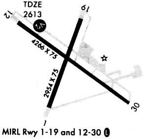
Runway Summary
| Runways: | 01/19 12/30 |
| Longest Runway: | 12/30 is 4268 ft (1301 m) long |
| Runways with an Instrument Approach: |
MIF Airport Runway Details
| Runway 01/19 | 2922 ft x 75 ft (891 m x 23 m) | |
| Runway Length Source: | NGS as of 03/19/2008 | |
| Surface: | Asphalt - Good condition - No special surface treatment | |
| Runway Edge Lights: | Medium Intensity | |
Runway Weight Bearing Capacity (in thousands of pounds) |
||
| Single Wheel Landing Gear: | 15.0 | |
Runway 01 |
Runway 19 |
|
Elevation: |
2614.5 | 2608.1 |
Latitude: |
31-34-43.2324N | 31-35-10.4627N |
Longitude: |
102-54-40.1835W | 102-54-28.8141W |
|
Runway True Alignment: |
020 | 200 |
Glide Path Angle: |
0.0 degrees | 0.0 degrees |
Traffic Pattern: |
Left | Left |
Runway Markings Type: |
Basic | Basic |
Runway Markings Condition: |
Good | Good |
Object at End: |
TANK | TREE |
Object Height: |
25 | 38 |
Distance from End: |
1190 | 595 |
Object Centerline Offset: |
60 ft. left of centerline | 200 ft. right of centerline |
| Runway 12/30 | 4268 ft x 75 ft (1301 m x 23 m) | |
| Runway Length Source: | NGS as of 03/19/2008 | |
| Surface: | Asphalt - Good condition - No special surface treatment | |
| Runway Edge Lights: | Medium Intensity | |
Runway Weight Bearing Capacity (in thousands of pounds) |
||
| Single Wheel Landing Gear: | 15.0 | |
Runway 12 |
Runway 30 |
|
Elevation: |
2606.2 | 2610.4 |
Latitude: |
31-35-09.6293N | 31-34-44.3287N |
Longitude: |
102-54-50.9317W | 102-54-11.4294W |
|
Runway True Alignment: |
127 | 307 |
Glide Path Angle: |
3.0 degrees | 0.0 degrees |
Traffic Pattern: |
Left | Left |
Runway Markings Type: |
Nonprecision Instrument | Nonprecision Instrument |
Runway Markings Condition: |
Good | Good |
Object at End: |
PLINE | TREE |
Object Height: |
55 | 46 |
Object Marked/Lighted?: |
Marked | |
Distance from End: |
1332 | 1035 |
Object Centerline Offset: |
60 ft. left of centerline | 200 ft. right of centerline |
Visual Glide Slope Indicators: |
2-Light PAPI On Left Side Of Runway | |
Threshold Crossing Height: |
24 |
Services
Airframe Repair: |
None |
Powerplant Repair: |
None |
Fuel Available: |
100LL |
Landing Fees: |
No |
Parking: |
Tiedowns available |
Maps & Diagrams
MIF Sectional
Flight Planning
at skyvector.com
at skyvector.com